Dreitannenriegel
Located in Grafling, Landkreis Deggendorf Coordinates: 48°53′50″ N 13°01′20″ E
- Elevation
- 1,092 m
- above sea level
- Local time
- UTC+01:00
- Europe/Berlin · UTC+01:00
- Airports
- JCL České Budějovice South Bohemian Airport103 km
- MUC Munich Airport109 km
About Dreitannenriegel
Dreitannenriegel is a mountain. Location: Grafling, Landkreis Deggendorf. Elevation: 1,092 m.
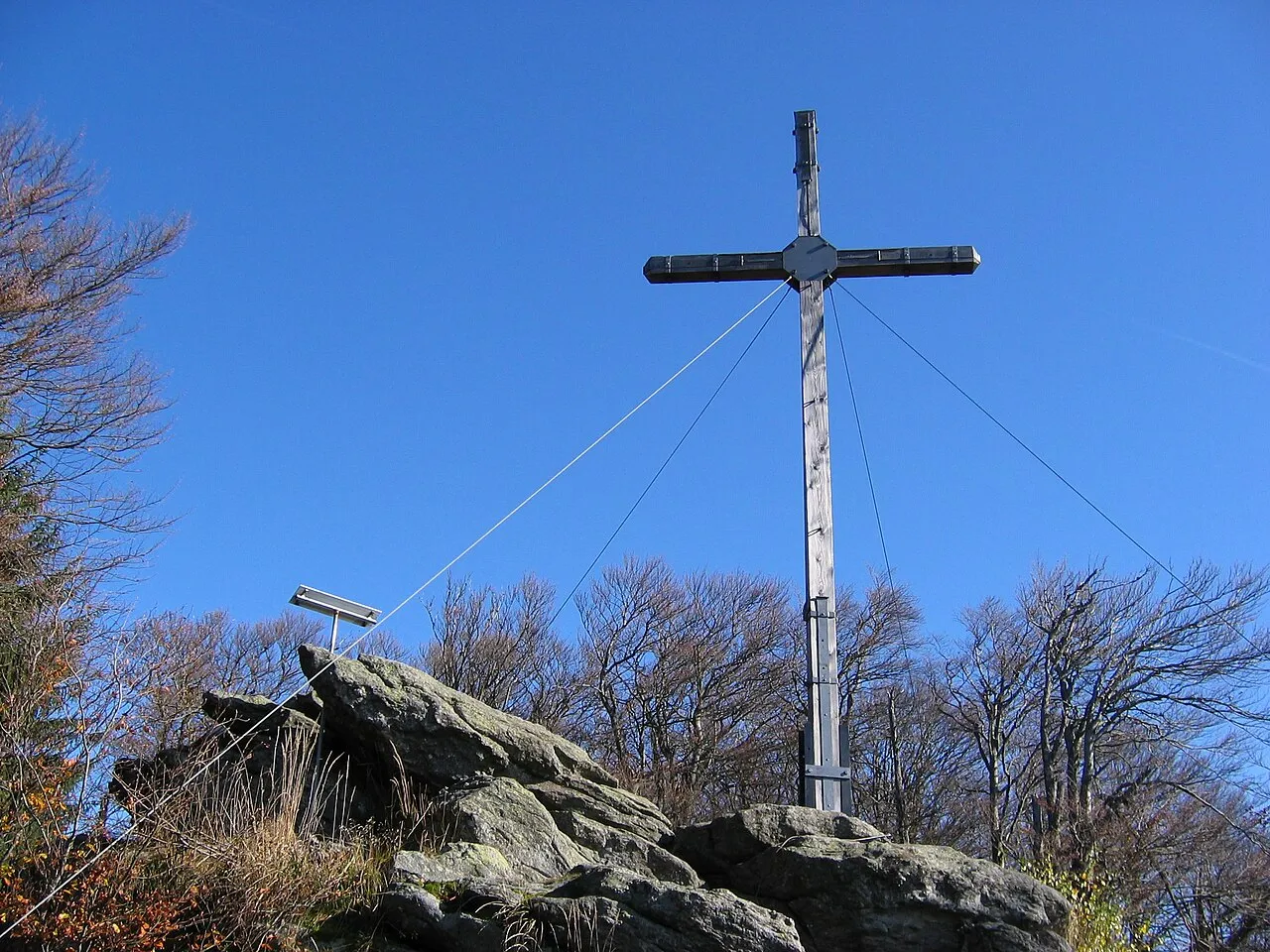
The Dreitannenriegel is a mountain, 1,090.2 m above sea level (NHN), in the Bavarian Forest. The mountain rises from the crest of the Anterior Bavarian Forest high above the Lower Bavarian county town of Deggendorf and lies in the municipality of Grafling. Nearby mountains are the Breitenauriegel, the Geißkopf and the Einödriegel. At the summit is a large summit cross and a display board, that explains the panorama which extends over large parts of Lower Bavaria.
Source: Wikipedia · CC BY-SA 4.0
Photos of Dreitannenriegel
-

Hobbeldock · CC BY-SA 4.0 -
Hausstein APneunzehn74 · CC BY-SA 4.0 -
Einödriegel MisterPicture · CC BY-SA 3.0 -
Breitenauriegel MisterPicture · CC BY-SA 3.0 -
Geißriegel APneunzehn74 · CC BY-SA 4.0


Climate of Dreitannenriegel
Best months for sightseeingBest months for sightseeing: July–August.
This month · November
A cold month
Day 2° · Night -4° · Rain 85 mm
- Hottest month
- July (day 18°)
- Coldest month
- January (night -8°)
- Wettest month
- July (124 mm)
- Driest month
- April (64 mm)
Bars: average monthly low and high temperature. Below: precipitation. Monthly averages for 1970–2000 at about 18 km resolution, adjusted for elevation. Highlighted months are mild and relatively dry. Source: WorldClim 2.1 (CC BY 4.0).
Show values as a table
| Month | Jan | Feb | Mar | Apr | May | Jun | Jul | Aug | Sep | Oct | Nov | Dec |
|---|---|---|---|---|---|---|---|---|---|---|---|---|
| Average high (°C) | -2° | -1° | 3° | 8° | 14° | 16° | 18° | 18° | 14° | 9° | 2° | -1° |
| Average low (°C) | -8° | -8° | -5° | -2° | 3° | 6° | 8° | 7° | 4° | 0° | -4° | -7° |
| Precipitation (mm) | 90 | 71 | 81 | 64 | 81 | 108 | 124 | 101 | 82 | 77 | 85 | 107 |
How to get to Dreitannenriegel
The nearest airport is České Budějovice South Bohemian Airport (JCL), 103 km to the east as the crow flies. The nearest large city is Regensburg, 69 km to the west.
Airports
- České Budějovice South Bohemian Airport (JCL) České Budějovice 103 kmeast
- Munich Airport (MUC) Munich 109 kmsouthwest
- Linz-Hörsching Airport (LNZ) Linz 113 kmsoutheast
Nearby large cities
- Regensburg Population: 151.4K 69 kmwest
- Linz Population: 204.8K 114 kmsoutheast
- Ingolstadt Population: 120.7K 118 kmwest
- Salzburg Population: 157.2K 122 kmsouth
- Munich Population: 1.5M 136 kmsouthwest
Straight-line distances; road distances are longer. Airport data: OurAirports.
Day trips from Dreitannenriegel
Within 100 km: 142 historic and cultural sites, 1,118 natural sites, 358 lakes, rivers and coasts.
0–25 km149 places
- Bohemian Forest Mountain 12 kmN
- Isar River 11 kmS
- Großer Arbersee Lake 24 kmNE
- Hackerweiher Lake 13 kmSW
25–60 km595 places
- Biber-Revier River 34 kmN
- Hamberg Mountain 49 kmSE
- Ringlholz Natural site 58 kmSE
- Edtwald Natural site 53 kmSE
60–100 km874 places
- Rannasee Lake 69 kmSE
- Teufelsschüssel Mountain 62 kmE
- Zwiesel Berg Mountain 65 kmE
- Wienerhöhe Mountain 97 kmS
Straight-line distances.
Nearest towns and villages
-
Rohrmünz Village, Grafling1.9 km SW
-
Bischofsmais Village, Landkreis Regen5 km NE
-
Hochoberndorf Village, Grafling2.8 km SW
-
Bischofsmais Village, Bischofsmais4.9 km NE
-
Grafling Village, Grafling3.5 km W
-
Arzting Village, Grafling3.5 km W
Nearby attractions & nature
Everything nearby-
Breitenauriegel Mountain, Deggendorf1.2 km NE
-
Geißriegel Mountain, Grafling1.2 km NW
-
Grünhüt Natural site, Bavaria0.5 km NW
-
Greisinger Hochwald Natural site, Bavaria1.1 km E
-
Sollerberg Mountain, Grafling1.7 km W
-
Hubertusbrunnen Natural site, Bavaria1.2 km NW
-
Steinberg Mountain, Grafling1.8 km NW
-
Hirschenkopf Mountain, Deggendorf2 km SE
Sources & licences
Data last updated: · 2 independent sources