- Elevation
- 811 m
- above sea level
- Local time
- UTC+01:00
- Europe/Berlin · UTC+01:00
- Airports
- JCL České Budějovice South Bohemian Airport81 km
- LNZ Linz-Hörsching Airport103 km
About Großer Sauruck
Großer Sauruck is a mountain. Location: Frauenau, Landkreis Regen. Elevation: 811 m. The best months to visit are June–August. The nearest airport is České Budějovice South Bohemian Airport (81 km). Nearby sights include Kleiner Sauruck and Ahornet.
Photos of Großer Sauruck
-
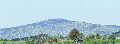
Eschenberg Konrad Lackerbeck · CC BY 3.0 -
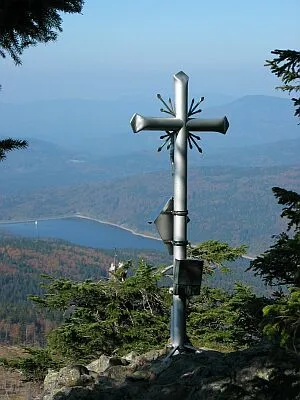
Kleiner Rachel Wikimedia Commons · CC BY-SA 3.0


Climate of Großer Sauruck
Best months for sightseeingBest months for sightseeing: June–August.
This month · November
A cold month
Day 4° · Night -3° · Rain 89 mm
- Hottest month
- July (day 20°)
- Coldest month
- January (night -7°)
- Wettest month
- July (126 mm)
- Driest month
- April (63 mm)
Bars: average monthly low and high temperature. Below: precipitation. Monthly averages for 1970–2000 at about 18 km resolution, adjusted for elevation. Highlighted months are mild and relatively dry. Source: WorldClim 2.1 (CC BY 4.0).
Show values as a table
| Month | Jan | Feb | Mar | Apr | May | Jun | Jul | Aug | Sep | Oct | Nov | Dec |
|---|---|---|---|---|---|---|---|---|---|---|---|---|
| Average high (°C) | 0° | 2° | 5° | 10° | 16° | 18° | 20° | 20° | 16° | 11° | 4° | 1° |
| Average low (°C) | -7° | -6° | -3° | 0° | 5° | 8° | 10° | 9° | 6° | 2° | -3° | -5° |
| Precipitation (mm) | 98 | 74 | 84 | 63 | 80 | 109 | 126 | 100 | 83 | 80 | 89 | 114 |
How to get to Großer Sauruck
The nearest airport is České Budějovice South Bohemian Airport (JCL), 81 km to the east as the crow flies. The nearest large city is Regensburg, 89 km to the west.
Airports
- České Budějovice South Bohemian Airport (JCL) České Budějovice 81 kmeast
- Linz-Hörsching Airport (LNZ) Linz 103 kmsoutheast
- Munich Airport (MUC) Munich 131 kmsouthwest
Nearby large cities
- Regensburg Population: 151.4K 89 kmwest
- Linz Population: 204.8K 102 kmsoutheast
- Salzburg Population: 157.2K 130 kmsouth
- Ingolstadt Population: 120.7K 141 kmwest
- Prague Population: 1.2M 149 kmnortheast
Straight-line distances; road distances are longer. Airport data: OurAirports.
Day trips from Großer Sauruck
Within 100 km: 133 historic and cultural sites, 917 natural sites, 332 lakes, rivers and coasts.
0–25 km195 places
- Bohemian Forest Mountain 24 kmW
- Rachelsee Lake 6 kmE
- Kleiner Arber See Lake 24 kmNW
- Großer Arbersee Lake 20 kmNW
25–60 km497 places
- Biber-Revier River 36 kmNW
- Rannasee Lake 58 kmSE
- Teufelsschüssel Mountain 44 kmSE
- Zwiesel Berg Mountain 47 kmSE
60–100 km690 places
- Zeissberg Mountain 100 kmSE
- Urhammer Berg Mountain 96 kmS
- Turmberg Mountain 92 kmS
- Sternstein Mountain 82 kmSE
Straight-line distances.
Nearest towns and villages
-
Frauenau Village, Frauenau3.8 km N
-
Spiegelau Village, Landkreis Freyung-Grafenau4.4 km SE
-
Flanitzhütte Village, Spiegelau1.4 km W
-
Unterfrauenau Village, Frauenau2.9 km N
-
Althütte Village, Spiegelau2 km S
-
Kirchdorf i.Wald Village, Landkreis Regen5.9 km SW
Nearby attractions & nature
Everything nearby-
Kleiner Sauruck Mountain, Frauenau0.5 km SW
-
Ahornet Natural site, Bavaria1.1 km N
-
Rothbach River, Bavaria1.3 km E
-
Eschenberg Mountain, Kirchdorf i.Wald3.8 km SW
-
Wagensonnriegel Mountain, Bavaria2.9 km W
-
Föhraubach River, Bavaria2.5 km E
-
Klingenbrunner Wald Natural site, Bavaria3.4 km SE
-
Kleiner Rachel Mountain, Frauenau5.4 km NE
Sources & licences
Data last updated: · 2 independent sources