- Elevation
- 555 m
- above sea level
- Local time
- UTC+01:00
- Europe/Berlin · UTC+01:00
- Airports
- MUC Munich Airport105 km
- JCL České Budějovice South Bohemian Airport126 km
About Haid
Haid is a village. Location: Konzell, Landkreis Straubing-Bogen. Elevation: 555 m. The best months to visit are June–August. The nearest airport is Munich Airport (105 km). Nearby sights include Unterberg and Sicklasberg.
Photos of Haid
-
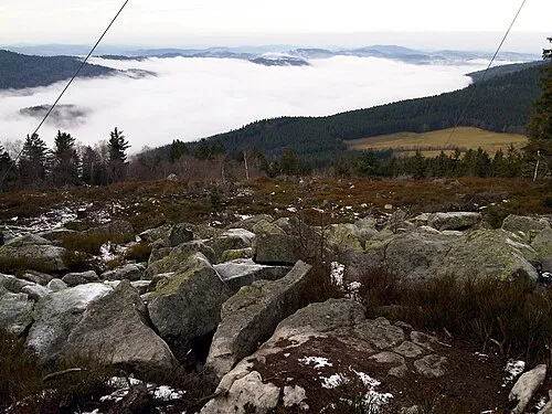
Käsplatte Gomera-b · CC0

Climate of Haid
Best months for sightseeingBest months for sightseeing: June–August.
This month · November
A cold month
Day 5° · Night -1° · Rain 67 mm
- Hottest month
- July (day 22°)
- Coldest month
- January (night -5°)
- Wettest month
- July (108 mm)
- Driest month
- April (55 mm)
Bars: average monthly low and high temperature. Below: precipitation. Monthly averages for 1970–2000 at about 18 km resolution, adjusted for elevation. Highlighted months are mild and relatively dry. Source: WorldClim 2.1 (CC BY 4.0).
Show values as a table
| Month | Jan | Feb | Mar | Apr | May | Jun | Jul | Aug | Sep | Oct | Nov | Dec |
|---|---|---|---|---|---|---|---|---|---|---|---|---|
| Average high (°C) | 1° | 2° | 7° | 11° | 17° | 20° | 22° | 21° | 17° | 11° | 5° | 2° |
| Average low (°C) | -5° | -5° | -1° | 2° | 6° | 10° | 11° | 11° | 8° | 3° | -1° | -3° |
| Precipitation (mm) | 68 | 56 | 64 | 55 | 77 | 99 | 108 | 91 | 72 | 67 | 67 | 82 |
How to get to Haid
The nearest airport is Munich Airport (MUC), 105 km to the southwest as the crow flies. The nearest large city is Regensburg, 45 km to the west.
Airports
- Munich Airport (MUC) Munich 105 kmsouthwest
- České Budějovice South Bohemian Airport (JCL) České Budějovice 126 kmeast
- Karlovy Vary Airport (KLV) Karlovy Vary 126 kmnorth
Nearby large cities
- Regensburg Population: 151.4K 45 kmwest
- Ingolstadt Population: 120.7K 101 kmwest
- Nuremberg Population: 515.5K 127 kmwest
- Fürth Population: 132K 133 kmwest
- Munich Population: 1.5M 134 kmsouthwest
Straight-line distances; road distances are longer. Airport data: OurAirports.
Day trips from Haid
Within 100 km: 240 historic and cultural sites, 1,513 natural sites, 422 lakes, rivers and coasts.
0–25 km164 places
- Biber-Revier River 25 kmNE
- Bohemian Forest Mountain 22 kmE
- Großer Hammerweiher Lake 14 kmW
- Zimmerberg Mountain 17 kmW
25–60 km622 places
- Isar River 36 kmSE
- Unterer Markweiher Lake 47 kmNW
- Thundorfer Weiher Lake 50 kmNW
- Stadlweiher Lake 37 kmNW
60–100 km1,389 places
- Rannasee Lake 98 kmSE
- Teufelsschüssel Mountain 89 kmSE
- Zwiesel Berg Mountain 92 kmSE
- Kohlberg Mountain 98 kmSE
Straight-line distances.
Nearby attractions & nature
Everything nearby-
Unterberg Mountain, Rattenberg2.6 km E
-
Sicklasberg Mountain, Rattenberg3.3 km SE
-
Kramerschopf Mountain, Konzell1.8 km E
-
Hochberg Mountain, Rattenberg1.7 km E
-
Gallnerberg Mountain, Konzell4.2 km SW
-
Sandbach River, Bavaria6.4 km NE
Sources & licences
Data last updated: