- Elevation
- 689 m
- above sea level
- Local time
- UTC+01:00
- Europe/Berlin · UTC+01:00
- Airports
- NUE Nuremberg Airport62 km
- STR Stuttgart Airport105 km
About Hesselberg
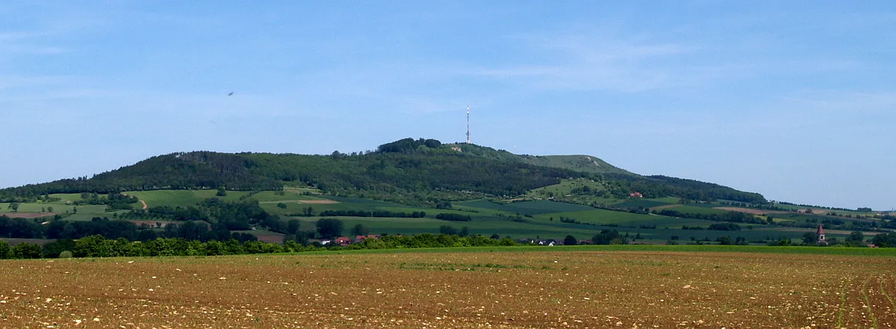
Hesselberg is a mountain. Location: Ehingen, Landkreis Ansbach. Elevation: 689 m.
Hesselberg (pronounced [ˈhɛsl̩ˌbɛʁk] ; 689 m above sea level) is the highest point in Middle Franconia and the Franconian Jura and is situated 60 km south west of Nuremberg, Germany. The mountain stands isolated and far from the center of the Franconian Jura, in its southwestern border region, 4 km to the north west of Wassertrüdingen. The mountain's first recorded name was Öselberg, which probably derived from öder Berg (bleak mountain).
Source: Wikipedia · CC BY-SA 4.0
Photos of Hesselberg
-

Wikimedia Commons · Public domain -

Jörg Braukmann · CC BY-SA 4.0 -

Castritus · CC BY-SA 4.0 -

Castritus · CC BY-SA 4.0 -

GerritR · CC BY-SA 4.0


Climate of Hesselberg
Best months for sightseeingBest months for sightseeing: June–August.
This month · November
A cold month
Day 5° · Night -1° · Rain 59 mm
- Hottest month
- August (day 22°)
- Coldest month
- January (night -5°)
- Wettest month
- June (83 mm)
- Driest month
- February (51 mm)
Bars: average monthly low and high temperature. Below: precipitation. Monthly averages for 1970–2000 at about 18 km resolution, adjusted for elevation. Highlighted months are mild and relatively dry. Source: WorldClim 2.1 (CC BY 4.0).
Show values as a table
| Month | Jan | Feb | Mar | Apr | May | Jun | Jul | Aug | Sep | Oct | Nov | Dec |
|---|---|---|---|---|---|---|---|---|---|---|---|---|
| Average high (°C) | 0° | 2° | 7° | 11° | 17° | 20° | 22° | 22° | 17° | 11° | 5° | 2° |
| Average low (°C) | -5° | -5° | -2° | 1° | 6° | 9° | 11° | 10° | 7° | 3° | -1° | -3° |
| Precipitation (mm) | 53 | 51 | 53 | 55 | 72 | 83 | 79 | 67 | 56 | 61 | 59 | 65 |
How to get to Hesselberg
The nearest airport is Nuremberg Airport (NUE), 62 km to the northeast as the crow flies. The nearest large city is Fürth, 56 km to the northeast.
Airports
- Nuremberg Airport (NUE) Nuremberg 62 kmnortheast
- Stuttgart Airport (STR) Stuttgart 105 kmsouthwest
- Memmingen Allgau Airport (FMM) Memmingen 122 kmsouth
Nearby large cities
- Fürth Population: 132K 56 kmnortheast
- Nuremberg Population: 515.5K 59 kmnortheast
- Erlangen Population: 102.7K 68 kmnortheast
- Ingolstadt Population: 120.7K 74 kmsoutheast
- Augsburg Population: 301.1K 82 kmsouth
Straight-line distances; road distances are longer. Airport data: OurAirports.
Day trips from Hesselberg
Within 100 km: 1,298 historic and cultural sites, 3,022 natural sites, 697 lakes, rivers and coasts.
0–25 km212 places
- Kreutweiher Lake 6 kmNE
- Klarweiher Lake 6 kmE
- Altmühlsee Lake 16 kmNE
- Hahnenkammsee Lake 18 kmSE
25–60 km1,077 places
- Hessental Concentration Camp Historic site 55 kmW
- Zusam River 44 kmS
- Uzbach River 59 kmNW
- Rosenweiher Lake 57 kmNE
60–100 km3,728 places
- Spitzelberg Mountain 87 kmNE
- Stollenberg Mountain 84 kmNE
- Deckersberg Mountain 82 kmNE
- Umpfer River 79 kmNW
Straight-line distances.
Nearest towns and villages
-
Ehingen Village, Ehingen2.3 km NE
-
Gerolfingen Village, Gerolfingen2 km SW
-
Gerolfingen Village, Landkreis Ansbach2.7 km SW
-
Wittelshofen Village, Landkreis Ansbach3.1 km W
-
Röckingen Village, Röckingen2.8 km SE
-
 Irsingen Village, Gerolfingen3.8 km SW
Nearby attractions & nature
Everything nearby-
Sendeturm Hesselberg Landmark, Gerolfingen0.1 km SW
-
Öttinger Forst Natural site, Bavaria6.8 km S
-
Eiselberg Mountain, Wassertrüdingen8.5 km E
-
Schlosspark Dennenlohe Natural site, Unterschwaningen7 km NE
-
Kreutweiher Lake, Bavaria5.6 km NE
-
Klarweiher Lake, Bavaria5.6 km E
-
Rastberg Mountain, Wassertrüdingen9.8 km E
-
Kastell Ruffenhofen Historic site, Wittelshofen4.1 km SW
Sources & licences
Data last updated: · 2 independent sources