- Population
- 135,098
- 135.1K
- Elevation
- 508 m
- above sea level
- Local time
- UTC+01:00
- Europe/Berlin · UTC+01:00
- Places inside
- 44
- listed under Landkreis Donau-Ries
- Airports
- NUE Nuremberg Airport80 km
- MUC Munich Airport94 km
About Landkreis Donau-Ries
Landkreis Donau-Ries is a municipality. Location: Swabia, Bavaria. Population: 135,098. Elevation: 508 m. The best months to visit are June–August. The nearest airport is Nuremberg Airport (80 km). Nearby sights include Schwalbenholz and Schwalb.
Photos of Landkreis Donau-Ries
-
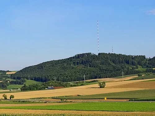
Hühnerberg Kreuzschnabel · CC BY-SA 3.0

Climate of Landkreis Donau-Ries
Best months for sightseeingBest months for sightseeing: June–August.
This month · November
A cold month
Day 5° · Night 0° · Rain 58 mm
- Hottest month
- July (day 23°)
- Coldest month
- January (night -4°)
- Wettest month
- June (92 mm)
- Driest month
- February (45 mm)
Bars: average monthly low and high temperature. Below: precipitation. Monthly averages for 1970–2000 at about 18 km resolution, adjusted for elevation. Highlighted months are mild and relatively dry. Source: WorldClim 2.1 (CC BY 4.0).
Show values as a table
| Month | Jan | Feb | Mar | Apr | May | Jun | Jul | Aug | Sep | Oct | Nov | Dec |
|---|---|---|---|---|---|---|---|---|---|---|---|---|
| Average high (°C) | 1° | 3° | 8° | 12° | 18° | 21° | 23° | 23° | 18° | 12° | 5° | 2° |
| Average low (°C) | -4° | -4° | 0° | 3° | 7° | 10° | 12° | 12° | 8° | 4° | 0° | -2° |
| Precipitation (mm) | 46 | 45 | 46 | 55 | 80 | 92 | 87 | 74 | 60 | 61 | 58 | 58 |
How to get to Landkreis Donau-Ries
The nearest airport is Nuremberg Airport (NUE), 80 km to the north as the crow flies. The nearest large city is Augsburg, 51 km to the south.
Airports
- Nuremberg Airport (NUE) Nuremberg 80 kmnorth
- Munich Airport (MUC) Munich 94 kmsoutheast
- Memmingen Allgau Airport (FMM) Memmingen 99 kmsouth
Nearby large cities
- Augsburg Population: 301.1K 51 kmsouth
- Ingolstadt Population: 120.7K 52 kmeast
- Ulm Population: 120.5K 71 kmsouthwest
- Nuremberg Population: 515.5K 76 kmnorth
- Fürth Population: 132K 76 kmnorth
Straight-line distances; road distances are longer. Airport data: OurAirports.
Day trips from Landkreis Donau-Ries
Within 100 km: 1,033 historic and cultural sites, 2,569 natural sites, 586 lakes, rivers and coasts.
0–25 km189 places
- Zusam River 13 kmS
- Hahnenkammsee Lake 16 kmN
- Viersteinberg Mountain 21 kmNE
- Uhlberg Mountain 15 kmNE
25–60 km1,031 places
- Kreutweiher Lake 34 kmN
- Klarweiher Lake 32 kmN
- Igelsbachsee Lake 39 kmN
- Altmühlsee Lake 35 kmN
60–100 km2,968 places
- Hessental Concentration Camp Historic site 77 kmNW
- Spitzelberg Mountain 98 kmNE
- Stollenberg Mountain 96 kmNE
- Deckersberg Mountain 92 kmNE
Straight-line distances.
Landkreis Donau-Ries and similar cities
Side by side with cities of similar size in the same country: population, elevation and climate.
| Measure | Landkreis Donau-Ries | Würzburg | Fürth | Paderborn |
|---|---|---|---|---|
| Population | 135.1K | 133.7K | 132K | 142.2K |
| Elevation | 508 m | 204 m | 302 m | 118 m |
| Summer day (hottest month) | 23° | 24° | 25° | 23° |
| Winter night (coldest month) | -4° | -2° | -3° | -1° |
| Annual rainfall | 762 mm | 659 mm | 718 mm | 934 mm |
| Best months | Jun–Aug | May–Sep | May–Sep | Jun–Aug |
| Distance | — | 122 km | 76 km | 352 km |
Climate values are 1970–2000 monthly averages; straight-line distance.
Places in Landkreis Donau-Ries
44 places- 1 Nördlingen 20.4K
- 2 Donauwörth 20K
- 3 Rain 9.1K
- 4 Wemding 5.8K
- 5 Harburg (Schwaben) 5.6K
- 6 Monheim 5.4K
- 7 Oettingen i.Bay. 5.2K
- 8 Asbach-Bäumenheim 4.8K
- 9 Tapfheim 4.1K
- 10 Mertingen 4K
- 11 Kaisheim, Markt 4K
- 12 Wallerstein, Markt 3.4K
- 13 Möttingen 2.7K
- 14 Oberndorf a.Lech 2.7K
- 15 Marxheim 2.6K
- 16 Fremdingen 2K
- 17 Buchdorf 2K
- 18 Deiningen 1.8K
- 19 Munningen 1.7K
- 20 Alerheim 1.7K
- 21 Huisheim 1.6K
- 22 Mönchsdeggingen 1.4K
- 23 Niederschönenfeld 1.4K
- 24 Wechingen 1.4K
- 25 Hainsfarth 1.4K
- 26 Fünfstetten 1.4K
- 27 Reimlingen 1.3K
- 28 Marktoffingen 1.3K
- 29 Maihingen 1.3K
- 30 Münster 1.2K
- 31 Genderkingen 1.2K
- 32 Holzheim 1.1K
- 33 Wolferstadt 1.1K
- 34 Ederheim 1.1K
- 35 Tagmersheim 1.1K
- 36 Auhausen 1.1K
- 37 Amerdingen 863
- 38 Megesheim 829
- 39 Daiting 809
- 40 Otting 797
- 41 Ehingen a.Ries 752
- 42 Rögling 612
- 43 Hohenaltheim 555
- 44 Forheim 523
Bar: population relative to the most populous place in this list.
Nearby attractions & nature
Everything nearby-
Schwalbenholz Natural site, Bavaria4 km N
-
Schwalb River, Bavaria5.3 km W
-
Harburger Karab Natural site, Bavaria6 km SE
-
Ottenhart Natural site, Bavaria7.2 km S
-
Eger River, Germany6.4 km W
-
Reisbach River, Bavaria6.8 km S
-
Mörschbach River, Bavaria7.1 km S
-
Ellerbach River, Bavaria7.6 km S
Sources & licences
Data last updated: