Markt Indersdorf, Markt
Located in Landkreis Dachau, Upper Bavaria Coordinates: 48°21′48″ N 11°23′10″ E
- Population
- 10,283
- 10.3K
- Elevation
- 465 m
- above sea level
- Local time
- UTC+01:00
- Europe/Berlin · UTC+01:00
- Places inside
- 40
- listed under Markt Indersdorf, Markt
- Airports
- MUC Munich Airport30 km
- FMM Memmingen Allgau Airport95 km
About Markt Indersdorf, Markt
Markt Indersdorf, Markt is a village. Location: Landkreis Dachau, Upper Bavaria. Population: 10,283. Elevation: 465 m. The best months to visit are June–August. The nearest airport is Munich Airport (30 km). Nearby sights include Rothbach and Bäckerholz.
Climate of Markt Indersdorf, Markt
Best months for sightseeingBest months for sightseeing: June–August.
This month · November
A cold month
Day 6° · Night 0° · Rain 64 mm
- Hottest month
- July (day 23°)
- Coldest month
- January (night -4°)
- Wettest month
- July (110 mm)
- Driest month
- January (46 mm)
Bars: average monthly low and high temperature. Below: precipitation. Monthly averages for 1970–2000 at about 18 km resolution, adjusted for elevation. Highlighted months are mild and relatively dry. Source: WorldClim 2.1 (CC BY 4.0).
Show values as a table
| Month | Jan | Feb | Mar | Apr | May | Jun | Jul | Aug | Sep | Oct | Nov | Dec |
|---|---|---|---|---|---|---|---|---|---|---|---|---|
| Average high (°C) | 2° | 4° | 8° | 13° | 18° | 21° | 23° | 23° | 19° | 13° | 6° | 3° |
| Average low (°C) | -4° | -4° | 0° | 3° | 7° | 10° | 12° | 11° | 8° | 4° | 0° | -2° |
| Precipitation (mm) | 46 | 46 | 50 | 62 | 84 | 107 | 110 | 93 | 73 | 62 | 64 | 56 |
How to get to Markt Indersdorf, Markt
The nearest airport is Munich Airport (MUC), 30 km to the east as the crow flies. The nearest large city is Munich, 29 km to the southeast.
Airports
- Munich Airport (MUC) Munich 30 kmeast
- Memmingen Allgau Airport (FMM) Memmingen 95 kmsouthwest
- Innsbruck Airport (INN) Innsbruck 123 kmsouth
Nearby large cities
- Munich Population: 1.5M 29 kmsoutheast
- Augsburg Population: 301.1K 36 kmwest
- Ingolstadt Population: 120.7K 45 kmnorth
- Regensburg Population: 151.4K 90 kmnortheast
- Ulm Population: 120.5K 103 kmwest
Straight-line distances; road distances are longer. Airport data: OurAirports.
Day trips from Markt Indersdorf, Markt
Within 100 km: 638 historic and cultural sites, 2,500 natural sites, 841 lakes, rivers and coasts.
0–25 km145 places
- Ulrichsberg Mountain 24 kmW
- Reigersberg Mountain 16 kmE
- Plattenberg Mountain 20 kmW
- Kreuzberg Mountain 10 kmE
25–60 km840 places
- elf-pavlik's tent Historic site 27 kmSE
- Loisach River 48 kmS
- Schwedeninsel Island 50 kmS
- Roseninsel Island 47 kmS
60–100 km2,994 places
- Bayerisches Oberland Mountain 79 kmS
- Frauenchiemsee Island 95 kmSE
- Schloss Hirschberg am Haarsee Historic site 63 kmS
- Herreninsel Island 94 kmSE
Straight-line distances.
Places in Markt Indersdorf, Markt
40 placesBar: population relative to the most populous place in this list.
Cities & villages35
- Ainhofen · Village
- Albersbach · Village
- Arnzell · Village
- Eglersried · Village
- Eichhofen · Village
- Eichstock · Village
- Engelbrechtsmühle · Village
- Frauenhofen · Village
- Gittersbach · Village
- Gundackersdorf · Village
- Harreszell · Village
- Hartwigshausen · Village
- Häusern · Village
- Hirtlbach · Village
- Hörgenbach · Village
- Indersdorf Kloster · Neighbourhood
- Karpfhofen · Village
- Kattalaich · Village
- Langenpettenbach · Village
- Lanzenried · Village
- Neuried · Village
- Ottmarshart · Village
- Puch · Village
- Riedhof · Village
- Siechhäusern · Neighbourhood
- Stachusried · Village
- Stangenreid · Village
- Straßbach · Village
- Täfern · Village
- Tiefenlachen · Village
- Wagenried · Village
- Weil · Village
- Westerholzhausen · Village
- Weyhern · Village
- Wöhr · Village
Mountains & nature1
- Feichelberg · Mountain
Nearby attractions & nature
Everything nearby-
Rothbach River, Bavaria0.6 km SW
-
Bäckerholz Natural site, Bavaria4.3 km SW
-
Klosterholz Natural site, Bavaria5.6 km NW
-
Karlholz Natural site, Bavaria5.6 km NW
-
Oberrother Pfarr Wald Natural site, Bavaria5.8 km SW
-
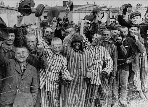 Dachau Concentration Camp Historic site, Dachau12 km SE
Sources & licences
Data last updated: