Hollfeld
Located in Landkreis Bayreuth, Upper Franconia Coordinates: 49°56′19″ N 11°17′19″ E
- Population
- 4,784
- 4.8K
- Elevation
- 391 m
- above sea level
- Local time
- UTC+01:00
- Europe/Berlin · UTC+01:00
- Places inside
- 27
- listed under Hollfeld
- Airports
- NUE Nuremberg Airport51 km
- ERF Erfurt-Weimar Airport118 km
About Hollfeld
Hollfeld is a village. Location: Landkreis Bayreuth, Upper Franconia. Population: 4,784. Elevation: 391 m. The best months to visit are June–August. The nearest airport is Nuremberg Airport (51 km). Nearby sights include Hain and Jungholz.
Photos of Hollfeld
-
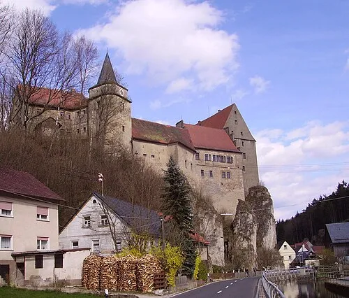
Burg Wiesentfels Immanuel Giel · Public domain

Climate of Hollfeld
Best months for sightseeingBest months for sightseeing: June–August.
This month · November
A cold month
Day 6° · Night 0° · Rain 70 mm
- Hottest month
- August (day 23°)
- Coldest month
- January (night -4°)
- Wettest month
- June (87 mm)
- Driest month
- April (55 mm)
Bars: average monthly low and high temperature. Below: precipitation. Monthly averages for 1970–2000 at about 18 km resolution, adjusted for elevation. Highlighted months are mild and relatively dry. Source: WorldClim 2.1 (CC BY 4.0).
Show values as a table
| Month | Jan | Feb | Mar | Apr | May | Jun | Jul | Aug | Sep | Oct | Nov | Dec |
|---|---|---|---|---|---|---|---|---|---|---|---|---|
| Average high (°C) | 2° | 3° | 8° | 12° | 18° | 20° | 22° | 23° | 18° | 12° | 6° | 3° |
| Average low (°C) | -4° | -4° | -1° | 2° | 7° | 10° | 12° | 11° | 8° | 4° | 0° | -2° |
| Precipitation (mm) | 72 | 58 | 65 | 55 | 62 | 87 | 86 | 61 | 65 | 70 | 70 | 86 |
How to get to Hollfeld
The nearest airport is Nuremberg Airport (NUE), 51 km to the south as the crow flies. The nearest large city is Erlangen, 44 km to the southwest.
Airports
- Nuremberg Airport (NUE) Nuremberg 51 kmsouth
- Erfurt-Weimar Airport (ERF) Erfurt 118 kmnorth
- Karlovy Vary Airport (KLV) Karlovy Vary 120 kmeast
Nearby large cities
- Erlangen Population: 102.7K 44 kmsouthwest
- Fürth Population: 132K 56 kmsouthwest
- Nuremberg Population: 515.5K 56 kmsouth
- Würzburg Population: 133.7K 97 kmwest
- Jena Population: 104.7K 112 kmnorth
Straight-line distances; road distances are longer. Airport data: OurAirports.
Day trips from Hollfeld
Within 100 km: 1,122 historic and cultural sites, 4,224 natural sites, 839 lakes, rivers and coasts.
0–25 km552 places
- Waldstadion Weismain Landmark 17 kmN
- Dornig Mountain 23 kmNW
- Lohe Mountain 13 kmSW
- Ziegenberg Mountain 8 kmNE
25–60 km2,246 places
- Spitzelberg Mountain 44 kmS
- Stollenberg Mountain 45 kmS
- Deckersberg Mountain 52 kmS
- Welles Weiher Lake 45 kmSW
60–100 km3,387 places
- Český Les Mountain 92 kmE
- Uzbach River 92 kmSW
- Badsee Lake 63 kmW
- Zipfelteich Lake 82 kmNE
Straight-line distances.
Places in Hollfeld
27 placesBar: population relative to the most populous place in this list.
Cities & villages19
- Drosendorf bei Hollfeld · Village
- Fernreuth · Village
- Freienfels · Village
- Hainbach · Village
- Höfen · Village
- Kainach · Village
- Krögelstein · Village
- Loch · Village
- Moggendorf · Village
- Neidenstein · Village
- Pilgerndorf · Village
- Schnackenwöhr · Village
- Schönfeld · Village
- Stechendorf · Village
- Tiefenlösau · Village
- Treppendorf · Village
- Weiher · Village
- Welkendorf · Village
- Wiesentfels · Village
Mountains & nature3
- Äußerer Berg · Mountain
- Mittelberg · Mountain
- Rappersberg · Mountain
Heritage & sights4
- Burgruine Neidenstein · Historic site
- Burg Wiesentfels · Historic site
- Schloß Freienfels · Historic site
- Schloss Weiher · Historic site
Nearby attractions & nature
Everything nearby-
Hain Natural site, Bavaria1.5 km NE
-
Jungholz Natural site, Bavaria2.4 km E
-
Rauhberg Mountain, Wonsees, Markt3.9 km E
-
Alleewaldung Natural site, Bavaria4 km W
-
Burgstall Mountain, Thurnau, Markt5.1 km E
-
Krähenberg Mountain, Thurnau, Markt5.4 km E
Other cities and towns in Landkreis Bayreuth
-
 Dörnhof Village, Aufseß6.9 km S
-
Plankenfels Village, Plankenfels6.9 km SE
-
 Schressendorf Village, Plankenfels6 km S
-
Braunersberg Village, Mistelgau6.8 km E
-
Truppach Village, Mistelgau6.9 km SE
Sources & licences
Data last updated: