Partenfeld
Located in Thurnau, Markt, Landkreis Kulmbach Coordinates: 50°03′17″ N 11°26′32″ E
- Elevation
- 314 m
- above sea level
- Local time
- UTC+01:00
- Europe/Berlin · UTC+01:00
- Airports
- NUE Nuremberg Airport67 km
- KLV Karlovy Vary Airport107 km
About Partenfeld
Partenfeld is a village. Location: Thurnau, Markt, Landkreis Kulmbach. Elevation: 314 m. The best months to visit are June–August. The nearest airport is Nuremberg Airport (67 km). Nearby sights include Friesenbach and Höhe.
Photos of Partenfeld
-
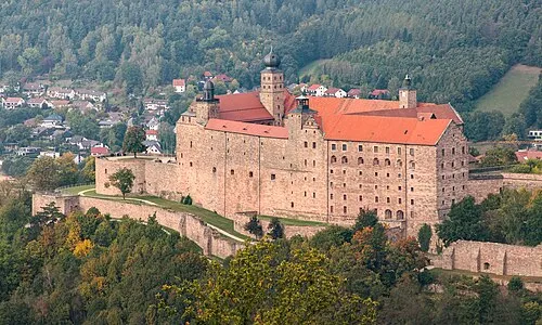
Plassenburg File:Plassenburg, Kulmbach from Rehturm.jpg : El Grafo derivative work: DYVER · CC BY-SA 4.0

Climate of Partenfeld
Best months for sightseeingBest months for sightseeing: June–August.
This month · November
A cold month
Day 6° · Night 1° · Rain 62 mm
- Hottest month
- July (day 24°)
- Coldest month
- January (night -3°)
- Wettest month
- July (84 mm)
- Driest month
- February (50 mm)
Bars: average monthly low and high temperature. Below: precipitation. Monthly averages for 1970–2000 at about 18 km resolution, adjusted for elevation. Highlighted months are mild and relatively dry. Source: WorldClim 2.1 (CC BY 4.0).
Show values as a table
| Month | Jan | Feb | Mar | Apr | May | Jun | Jul | Aug | Sep | Oct | Nov | Dec |
|---|---|---|---|---|---|---|---|---|---|---|---|---|
| Average high (°C) | 2° | 4° | 8° | 13° | 19° | 22° | 24° | 23° | 19° | 13° | 6° | 3° |
| Average low (°C) | -3° | -3° | 0° | 2° | 7° | 10° | 12° | 11° | 8° | 4° | 1° | -2° |
| Precipitation (mm) | 63 | 50 | 58 | 50 | 59 | 79 | 84 | 61 | 59 | 61 | 62 | 75 |
How to get to Partenfeld
The nearest airport is Nuremberg Airport (NUE), 67 km to the southwest as the crow flies. The nearest large city is Erlangen, 60 km to the southwest.
Airports
- Nuremberg Airport (NUE) Nuremberg 67 kmsouthwest
- Karlovy Vary Airport (KLV) Karlovy Vary 107 kmeast
- Erfurt-Weimar Airport (ERF) Erfurt 108 kmnorth
Nearby large cities
- Erlangen Population: 102.7K 60 kmsouthwest
- Nuremberg Population: 515.5K 72 kmsouth
- Fürth Population: 132K 72 kmsouthwest
- Jena Population: 104.7K 98 kmnorth
- Gera Population: 104.7K 102 kmnortheast
Straight-line distances; road distances are longer. Airport data: OurAirports.
Day trips from Partenfeld
Within 100 km: 935 historic and cultural sites, 4,230 natural sites, 842 lakes, rivers and coasts.
0–25 km410 places
- Waldstadion Weismain Landmark 14 kmW
- Zweinzelberg Mountain 18 kmNW
- Ziegenberg Mountain 10 kmS
- Zaunberg Mountain 6 kmNW
25–60 km2,269 places
- Spitzelberg Mountain 55 kmS
- Stollenberg Mountain 57 kmS
- Unterer Herrnsee Lake 51 kmSW
- Schwanensee Lake 55 kmNE
60–100 km3,328 places
- Deckersberg Mountain 63 kmS
- Pláň Mountain 92 kmE
- Český Les Mountain 87 kmSE
- Roda River 93 kmN
Straight-line distances.
Nearby attractions & nature
Everything nearby-
Friesenbach River, Bavaria0.5 km NE
-
Höhe Mountain, Thurnau, Markt3.2 km S
-
Eichberg Mountain, Neudrossenfeld3.7 km E
-
Herrenberg Mountain, Kulmbach3.2 km N
-
Rauher Berg Mountain, Trebgast3.6 km E
-
Plassenburg Historic site, Kulmbach6.1 km N
Other cities and towns in Thurnau, Markt
-
 Limmersdorf Village, Thurnau, Markt5.7 km SW
-
 Berndorf Village, Thurnau, Markt6 km SW
-
Hutschdorf Village, Thurnau, Markt2.1 km SW
-
Menchau Village, Thurnau, Markt6.7 km SW
-
Hörlinreuth Village, Thurnau, Markt2.9 km SW
-
Forstleithen Village, Thurnau, Markt5.3 km S
Sources & licences
Data last updated: