Bauernfichten
Located in Löwenberger Land, Landkreis Oberhavel Coordinates: 52°55′07″ N 13°18′19″ E
- Elevation
- 43 m
- above sea level
- Airports
- BER Berlin Brandenburg Airport63 km
- HDF Heringsdorf Airport121 km
About Bauernfichten
Bauernfichten is a natural site. Location: Löwenberger Land, Landkreis Oberhavel. The best months to visit are June–August. The nearest airport is Berlin Brandenburg Airport (63 km). Nearby sights include Hohe Berge and Hoher Dung.
Photos of Bauernfichten
-
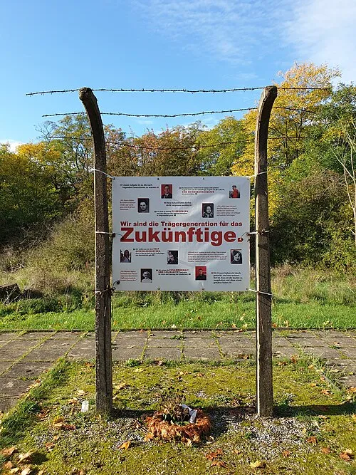
Grüneberg Concentration Camp Mwehle · CC BY-SA 4.0

Climate of Bauernfichten
Best months for sightseeingBest months for sightseeing: June–August.
This month · November
A cold month
Day 7° · Night 2° · Rain 45 mm
- Hottest month
- July (day 23°)
- Coldest month
- January (night -3°)
- Wettest month
- June (61 mm)
- Driest month
- February (31 mm)
Bars: average monthly low and high temperature. Below: precipitation. Monthly averages for 1970–2000 at about 18 km resolution, adjusted for elevation. Highlighted months are mild and relatively dry. Source: WorldClim 2.1 (CC BY 4.0).
Show values as a table
| Month | Jan | Feb | Mar | Apr | May | Jun | Jul | Aug | Sep | Oct | Nov | Dec |
|---|---|---|---|---|---|---|---|---|---|---|---|---|
| Average high (°C) | 2° | 3° | 7° | 13° | 18° | 21° | 23° | 23° | 18° | 13° | 7° | 3° |
| Average low (°C) | -3° | -2° | 0° | 3° | 8° | 11° | 13° | 13° | 9° | 5° | 2° | -1° |
| Precipitation (mm) | 42 | 31 | 39 | 35 | 54 | 61 | 61 | 57 | 45 | 39 | 45 | 50 |
How to get to Bauernfichten
The nearest airport is Berlin Brandenburg Airport (BER), 63 km to the south as the crow flies. The nearest large city is Berlin, 44 km to the south.
Airports
- Berlin Brandenburg Airport (BER) Berlin 63 kmsouth
- Heringsdorf Airport (HDF) Zirchow 121 kmnortheast
- Solidarity Szczecin–Goleniów Airport (SZZ) Szczecin(Glewice) 130 kmnortheast
Nearby large cities
- Berlin Population: 3.4M 44 kmsouth
- Potsdam Population: 184.8K 60 kmsouth
- Magdeburg Population: 244.3K 143 kmsouthwest
- Rostock Population: 198.3K 151 kmnorthwest
- Wolfsburg Population: 123.1K 180 kmwest
Straight-line distances; road distances are longer. Airport data: OurAirports.
Day trips from Bauernfichten
Within 100 km: 512 historic and cultural sites, 2,267 natural sites, 1,787 lakes, rivers and coasts.
0–25 km341 places
- Der Raatz Island 16 kmN
- Werder Island 24 kmW
- Wutzsee Lake 21 kmW
- Wutzsee Lake 9 kmSE
25–60 km1,973 places
- Schlachtensee Lake 53 kmS
- Valentinswerder Island 40 kmS
- Scharfenberg Island 39 kmS
- Dahme River River 56 kmS
60–100 km2,252 places
- Mittelbruch Island 74 kmSW
- Freundschaftsinsel Island 61 kmS
- Buhnenwerder Island 81 kmSW
- Herrenwerder Island 76 kmE
Straight-line distances.
Nearest towns and villages
-
Falkenthaler Plan Village, Löwenberger Land0.9 km N
-
 Falkenthal Village, Löwenberger Land1.8 km S
-
 Zehdenick Village, Landkreis Oberhavel7.4 km N
-
 Bergsdorf Village, Zehdenick3.2 km NW
-
 Liebenberg Village, Löwenberger Land4.1 km SW
-
Zehdenick Town, Zehdenick6.9 km N
Nearby attractions & nature
Everything nearby-
Hohe Berge Mountain, Löwenberger Land0.4 km SW
-
Hoher Dung Mountain, Zehdenick2.2 km NW
-
Gallberg Mountain, Zehdenick3.7 km NW
-
Zehdenicker Bürgerheide Natural site, Brandenburg3.2 km NE
-
Schanzenberg Mountain, Löwenberger Land3.5 km SE
-
Hohe Timpberg Mountain, Zehdenick4.3 km NW
-
Rollberg Mountain, Zehdenick3.6 km W
-
Hoher Timpberg Mountain, Zehdenick5 km NW
Sources & licences
Data last updated: