Rollberg
Located in Fehrbellin, Landkreis Ostprignitz-Ruppin Coordinates: 52°50′45″ N 12°41′47″ E
- Elevation
- 47 m
- above sea level
- Local time
- UTC+01:00
- Europe/Berlin · UTC+01:00
- Airports
- BER Berlin Brandenburg Airport77 km
- RLG Rostock-Laage Airport123 km
About Rollberg
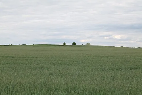
Rollberg is a mountain. Location: Fehrbellin, Landkreis Ostprignitz-Ruppin. Elevation: 47 m. The best months to visit are June–August. The nearest airport is Berlin Brandenburg Airport (77 km). Nearby sights include Hoher Berg and Fuchsberg.
Climate of Rollberg
Best months for sightseeingBest months for sightseeing: June–August.
This month · November
A cold month
Day 7° · Night 2° · Rain 41 mm
- Hottest month
- July (day 23°)
- Coldest month
- January (night -3°)
- Wettest month
- June (60 mm)
- Driest month
- April (32 mm)
Bars: average monthly low and high temperature. Below: precipitation. Monthly averages for 1970–2000 at about 18 km resolution, adjusted for elevation. Highlighted months are mild and relatively dry. Source: WorldClim 2.1 (CC BY 4.0).
Show values as a table
| Month | Jan | Feb | Mar | Apr | May | Jun | Jul | Aug | Sep | Oct | Nov | Dec |
|---|---|---|---|---|---|---|---|---|---|---|---|---|
| Average high (°C) | 2° | 3° | 8° | 13° | 18° | 21° | 23° | 23° | 18° | 13° | 7° | 4° |
| Average low (°C) | -3° | -2° | 0° | 3° | 8° | 11° | 13° | 13° | 9° | 6° | 2° | -1° |
| Precipitation (mm) | 42 | 33 | 39 | 32 | 50 | 60 | 58 | 52 | 46 | 39 | 41 | 49 |
How to get to Rollberg
The nearest airport is Berlin Brandenburg Airport (BER), 77 km to the southeast as the crow flies. The nearest large city is Potsdam, 56 km to the southeast.
Airports
- Berlin Brandenburg Airport (BER) Berlin 77 kmsoutheast
- Rostock-Laage Airport (RLG) Laage 123 kmnorth
- Heringsdorf Airport (HDF) Zirchow 150 kmnortheast
Nearby large cities
- Potsdam Population: 184.8K 56 kmsoutheast
- Berlin Population: 3.4M 60 kmsoutheast
- Magdeburg Population: 244.3K 107 kmsouthwest
- Wolfsburg Population: 123.1K 138 kmwest
- Rostock Population: 198.3K 143 kmnorth
Straight-line distances; road distances are longer. Airport data: OurAirports.
Day trips from Rollberg
Within 100 km: 569 historic and cultural sites, 2,683 natural sites, 1,731 lakes, rivers and coasts.
0–25 km192 places
- Unterseeinsel Island 20 kmNW
- Werder Island 23 kmNE
- Insel im Bützsee Island 13 kmE
- Zermützelsee Lake 21 kmNE
25–60 km1,804 places
- Schlachtensee Lake 57 kmSE
- Valentinswerder Island 48 kmSE
- Scharfenberg Island 48 kmSE
- Freibad Tegelsee Beach 48 kmSE
60–100 km2,987 places
- Ehle River 97 kmSW
- Dahme River River 74 kmSE
- Strandbad Beach 86 kmE
- Burgwallinsel Island 87 kmNE
Straight-line distances.
Nearest towns and villages
-
 Manker Village, Fehrbellin1.2 km W
-
Protzen Village, Fehrbellin1.8 km E
-
 Temnitztal Village, Landkreis Ostprignitz-Ruppin4.2 km W
-
Küdow Village, Temnitztal2.2 km NW
-
Fehrbellin Town, Fehrbellin5.8 km SE
-
Feldberg Village, Fehrbellin3.8 km SE
Nearby attractions & nature
Everything nearby-
Hoher Berg Mountain, Fehrbellin2.7 km E
-
Fuchsberg Mountain, Fehrbellin3.3 km E
-
Blumenthalberg Mountain, Temnitztal4.3 km W
-
Ruppiner Berg Mountain, Temnitztal3.8 km W
-
Bocksberg Mountain, Dabergotz4.7 km N
-
Todtenpfuhl Lake, Brandenburg3.2 km W
-
Lange Heiningenberg Mountain, Temnitztal5.8 km NW
-
Gruzberg Mountain, Temnitztal5.2 km W
More nature in Germany
-
Giebkenberg Mountain, Fehrbellin6.4 km S
-
Elsholzberg Mountain, Fehrbellin6.7 km S
-
Kiek Berg Mountain, Fehrbellin10 km SE
-
Weinberg Mountain, Fehrbellin8.2 km S
-
 Silberberg Mountain, Fehrbellin15 km SE
-
Sandberg Mountain, Fehrbellin9.8 km SE
Sources & licences
Data last updated: · 2 independent sources