- Elevation
- 90 m
- above sea level
- Local time
- UTC+01:00
- Europe/Berlin · UTC+01:00
- Airports
- BER Berlin Brandenburg Airport29 km
- DRS Dresden Airport109 km
About Weinberg
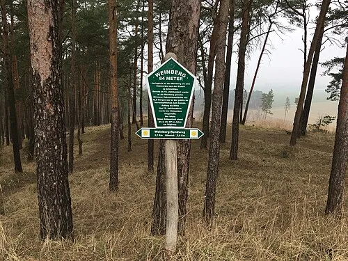
Weinberg is a mountain. Location: Zossen, Landkreis Teltow-Fläming. Elevation: 90 m. The best months to visit are June–August. The nearest airport is Berlin Brandenburg Airport (29 km). Nearby sights include Schwarzer Berg and Langer Berg.
Climate of Weinberg
Best months for sightseeingBest months for sightseeing: June–August.
This month · November
A cold month
Day 7° · Night 1° · Rain 46 mm
- Hottest month
- July (day 23°)
- Coldest month
- January (night -3°)
- Wettest month
- July (80 mm)
- Driest month
- April (28 mm)
Bars: average monthly low and high temperature. Below: precipitation. Monthly averages for 1970–2000 at about 18 km resolution, adjusted for elevation. Highlighted months are mild and relatively dry. Source: WorldClim 2.1 (CC BY 4.0).
Show values as a table
| Month | Jan | Feb | Mar | Apr | May | Jun | Jul | Aug | Sep | Oct | Nov | Dec |
|---|---|---|---|---|---|---|---|---|---|---|---|---|
| Average high (°C) | 3° | 4° | 8° | 13° | 19° | 22° | 23° | 23° | 18° | 13° | 7° | 4° |
| Average low (°C) | -3° | -3° | 0° | 3° | 8° | 11° | 13° | 12° | 9° | 5° | 1° | -1° |
| Precipitation (mm) | 42 | 35 | 38 | 28 | 50 | 49 | 80 | 64 | 51 | 34 | 46 | 43 |
How to get to Weinberg
The nearest airport is Berlin Brandenburg Airport (BER), 29 km to the north as the crow flies. The nearest large city is Potsdam, 46 km to the northwest.
Airports
- Berlin Brandenburg Airport (BER) Berlin 29 kmnorth
- Dresden Airport (DRS) Dresden 109 kmsouth
- Leipzig/Halle Airport (LEJ) Schkeuditz 117 kmsouthwest
Nearby large cities
- Potsdam Population: 184.8K 46 kmnorthwest
- Berlin Population: 3.4M 48 kmnorth
- Leipzig Population: 505K 117 kmsouthwest
- Dresden Population: 564.9K 118 kmsouth
- Halle Population: 237.9K 127 kmsouthwest
Straight-line distances; road distances are longer. Airport data: OurAirports.
Day trips from Weinberg
Within 100 km: 455 historic and cultural sites, 1,631 natural sites, 1,142 lakes, rivers and coasts.
0–25 km198 places
- Meierei-See Lake 23 kmSE
- Ziestsee Lake 24 kmNE
- Ziestsee Lake 24 kmNE
- Zemminsee Lake 10 kmNE
25–60 km1,101 places
- Schlachtensee Lake 44 kmNW
- Valentinswerder Island 56 kmN
- Scharfenberg Island 56 kmN
- Dahme River River 39 kmN
60–100 km1,929 places
- Lutzke River 77 kmE
- Mittelbruch Island 74 kmNW
- Buhnenwerder Island 80 kmNW
- Insel im Bützsee Island 92 kmNW
Straight-line distances.
Nearest towns and villages
-
 Baruth/Mark Village, Landkreis Teltow-Fläming6 km S
-
Zesch Village, Zossen1.8 km NW
-
 Lindenbrück Village, Zossen4.1 km NW
-
Baruth Village, Baruth/Mark6.5 km S
-
Funkenmühle Village, Zossen5 km NW
-
Teupitz Village, Landkreis Dahme-Spreewald6.8 km NE
Nearby attractions & nature
Everything nearby-
Schwarzer Berg Mountain, Zossen1.1 km W
-
Langer Berg Mountain, Zossen1.9 km N
-
Forst Baruth Natural site, Brandenburg1.9 km S
-
Wurzelberg Mountain, Zossen2.7 km N
-
Großer Zeschsee Lake, Brandenburg1.8 km NW
-
Motzenberg Mountain, Zossen3.5 km NW
-
Galgenberg Mountain, Zossen3.9 km N
-
Kleiner Zeschsee Lake, Brandenburg2.4 km N
More nature in Germany
-
Schirknitzberg Mountain, Zossen7.4 km N
-
Eichberg Mountain, Zossen7.8 km N
-
Jägersberg Mountain, Zossen9.9 km N
-
Wierachberg Mountain, Zossen11 km N
-
Guhringsberg Mountain, Zossen12 km N
-
 Weinberg Mountain, Zossen22 km NW
Sources & licences
Data last updated: · 2 independent sources