
- Elevation
- 203 m
- above sea level
- Local time
- UTC+01:00
- Europe/Berlin · UTC+01:00
- Airports
- KSF Kassel Airport49 km
- ERF Erfurt-Weimar Airport74 km
About Bischhausen
Bischhausen is a village. Location: Waldkappel, Werra-Meißner-Kreis. Elevation: 203 m. The best months to visit are June–August. The nearest airport is Kassel Airport (49 km). Nearby sights include Honigberg and Hosbach.
At a glance
- Area
- 17.4 km²
Source: Wikidata
Photos of Bischhausen
-
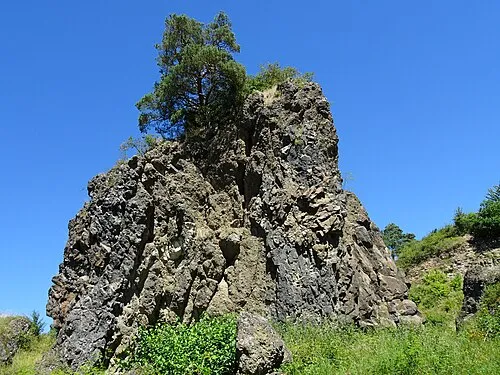
Blaue Kuppe Heinz K. S · CC BY-SA 4.0

Climate of Bischhausen
Best months for sightseeingBest months for sightseeing: June–August.
This month · November
A cold month
Day 7° · Night 2° · Rain 66 mm
- Hottest month
- August (day 23°)
- Coldest month
- February (night -2°)
- Wettest month
- June (78 mm)
- Driest month
- February (48 mm)
Bars: average monthly low and high temperature. Below: precipitation. Monthly averages for 1970–2000 at about 18 km resolution, adjusted for elevation. Highlighted months are mild and relatively dry. Source: WorldClim 2.1 (CC BY 4.0).
Show values as a table
| Month | Jan | Feb | Mar | Apr | May | Jun | Jul | Aug | Sep | Oct | Nov | Dec |
|---|---|---|---|---|---|---|---|---|---|---|---|---|
| Average high (°C) | 3° | 4° | 8° | 13° | 18° | 21° | 23° | 23° | 18° | 13° | 7° | 4° |
| Average low (°C) | -2° | -2° | 1° | 3° | 8° | 11° | 12° | 12° | 9° | 5° | 2° | 0° |
| Precipitation (mm) | 59 | 48 | 59 | 53 | 67 | 78 | 76 | 62 | 61 | 61 | 66 | 70 |
How to get to Bischhausen
The nearest airport is Kassel Airport (KSF), 49 km to the northwest as the crow flies. The nearest large city is Kassel, 36 km to the northwest.
Airports
- Kassel Airport (KSF) Calden 49 kmnorthwest
- Erfurt-Weimar Airport (ERF) Erfurt 74 kmeast
- Paderborn Lippstadt Airport (PAD) Büren 106 kmnorthwest
Nearby large cities
- Kassel Population: 197.2K 36 kmnorthwest
- Göttingen Population: 122.1K 44 kmnorth
- Erfurt Population: 218.8K 79 kmeast
- Paderborn Population: 142.2K 105 kmnorthwest
- Jena Population: 104.7K 118 kmeast
Straight-line distances; road distances are longer. Airport data: OurAirports.
Day trips from Bischhausen
Within 100 km: 417 historic and cultural sites, 5,744 natural sites, 794 lakes, rivers and coasts.
0–25 km567 places
- Frieda River 15 kmNE
- Zwickelsberg Mountain 21 kmE
- Zungenkopf Mountain 3 kmNE
- Zipfel Mountain 15 kmSE
25–60 km1,996 places
- Felda River 35 kmS
- Eitra River 39 kmS
- Baune River 34 kmW
- Vollmarshäuser Teich Lake 29 kmNW
60–100 km4,392 places
- Buchenwald concentration camp Historic site 93 kmE
- Wande River 65 kmNW
- Erpe River 65 kmNW
- Schalk River 85 kmNE
Straight-line distances.
Nearby attractions & nature
Everything nearbyOther cities and towns in Waldkappel
-
 Rechtebach Village, Waldkappel5 km SW
-
Harmuthsachsen Village, Waldkappel5.8 km NW
-
 Burghofen Village, Waldkappel7.3 km W
-
Rodebach Village, Waldkappel6.3 km NW
-
 Hasselbach Village, Waldkappel8.1 km NW
-
Mäckelsdorf Village, Waldkappel6.9 km W
Sources & licences
Data last updated: · 2 independent sources