Sengwarden
Located in Wilhelmshaven, Kreisfreie Stadt Wilhelmshaven Coordinates: 53°35′37″ N 8°02′50″ E

- Elevation
- 4 m
- above sea level
- Local time
- UTC+01:00
- Europe/Berlin · UTC+01:00
- Airports
- FCN Sea-Airport Cuxhaven/Nordholz / Nordholz Naval Airbase45 km
- BRE Bremen Airport78 km
About Sengwarden
Sengwarden is a village. Location: Wilhelmshaven, Kreisfreie Stadt Wilhelmshaven. Elevation: 4 m.
The village of Sengwarden lies north of Wilhelmshaven, Germany. The place was documented for the first time in 1168, was the site of a post-World War II British sector displaced person camp, and since 1972 has been administratively attached to the city Wilhelmshaven. Previously, the municipality belonged to the district Friesland. Sengwarden borders on the Wilhelmshaven suburbs Fedderwarden and Voslapp as well as the Friesland districts of Sillenstede and Hooksiel.
Source: Wikipedia · CC BY-SA 4.0
At a glance
- Area
- 25.6 km²
Source: Wikidata
Photos of Sengwarden
-

Crocodile2020 · CC BY-SA 4.0 -

Klinkenborg · CC BY-SA 4.0 -

Klinkenborg · CC BY-SA 4.0 -

Gerd Fahrenhorst · CC BY-SA 3.0 -

Rudolf C22 · CC BY-SA 4.0


Climate of Sengwarden
Best months for sightseeingBest months for sightseeing: June–August.
This month · November
A cold month
Day 8° · Night 3° · Rain 85 mm
- Hottest month
- August (day 21°)
- Coldest month
- February (night -1°)
- Wettest month
- November (85 mm)
- Driest month
- February (45 mm)
Bars: average monthly low and high temperature. Below: precipitation. Monthly averages for 1970–2000 at about 18 km resolution, adjusted for elevation. Highlighted months are mild and relatively dry. Source: WorldClim 2.1 (CC BY 4.0).
Show values as a table
| Month | Jan | Feb | Mar | Apr | May | Jun | Jul | Aug | Sep | Oct | Nov | Dec |
|---|---|---|---|---|---|---|---|---|---|---|---|---|
| Average high (°C) | 4° | 5° | 8° | 11° | 17° | 19° | 21° | 21° | 18° | 13° | 8° | 5° |
| Average low (°C) | -1° | -1° | 1° | 4° | 8° | 11° | 13° | 13° | 10° | 7° | 3° | 1° |
| Precipitation (mm) | 71 | 45 | 64 | 50 | 59 | 78 | 79 | 67 | 79 | 72 | 85 | 76 |
How to get to Sengwarden
The nearest airport is Sea-Airport Cuxhaven/Nordholz / Nordholz Naval Airbase (FCN), 45 km to the northeast as the crow flies. For international flights: Bremen Airport (BRE) (78 km). The nearest large city is Bremerhaven, 35 km to the east.
Airports
- Sea-Airport Cuxhaven/Nordholz / Nordholz Naval Airbase (FCN) Wurster Nordseeküste 45 kmnortheast
- Bremen Airport (BRE) Bremen 78 kmsoutheast
- Groningen Airport Eelde (GRQ) Groningen 111 kmsouthwest
Nearby large cities
- Bremerhaven Population: 118.6K 35 kmeast
- Oldenburg Population: 159.2K 52 kmsouth
- Bremen Population: 546.5K 77 kmsoutheast
- Groningen Population: 244.8K 107 kmwest
- Osnabrück Population: 166.5K 147 kmsouth
Straight-line distances; road distances are longer. Airport data: OurAirports.
Day trips from Sengwarden
Within 100 km: 173 historic and cultural sites, 725 natural sites, 632 lakes, rivers and coasts.
0–25 km102 places
- Strand Harlesiel Beach 21 kmNW
- Friesenstrand Beach 13 kmE
- Minsener Oog Island 19 kmN
- Alte Mellum Island 16 kmNE
25–60 km482 places
- East Frisian Islands Island 44 kmW
- Norderney Island 55 kmW
- Insel Spiekeroog Island 30 kmNW
- Baltrum Island 45 kmW
60–100 km946 places
- Borkum Island 90 kmW
- Juist Island 70 kmW
- Nordstrand Beach 85 kmW
- Südstrand Beach 66 kmN
Straight-line distances.
Nearby attractions & nature
Everything nearby-
Inhausersieler Tief River, Lower Saxony0.4 km S
-
Sengwarder Verbindungstief River, Wilhelmshaven2.3 km S
-
Windmeßmast Wilhelmshaven Landmark, Wilhelmshaven2.5 km N
-
Anzeteler Grenzleide River, Lower Saxony2.2 km S
-
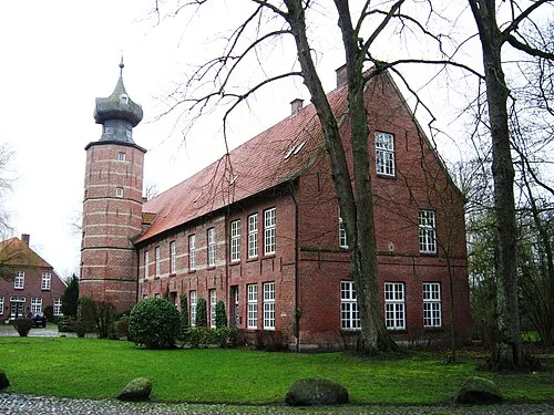 Burg Kniphausen Historic site, Wilhelmshaven4.8 km S
-
Naturschutzgebiet Voslapper Groden-Nord Natural site, Wilhelmshaven3.6 km NE
Other cities and towns in Wilhelmshaven
-
 Voslapp Neighbourhood, Wilhelmshaven3.9 km E
-
Fedderwardergroden Neighbourhood, Wilhelmshaven3.8 km SE
-
 Altengroden Neighbourhood, Wilhelmshaven5.3 km SE
-
 Rüstersiel Village, Wilhelmshaven5.7 km SE
-
Westerhausen Village, Wilhelmshaven2.1 km NW
-
Sengwarder Altendeich Village, Wilhelmshaven2.3 km SE
Sources & licences
Data last updated: · 2 independent sources