
- Elevation
- 434 m
- above sea level
- Local time
- UTC+01:00
- Europe/Berlin · UTC+01:00
- Airports
- KSF Kassel Airport83 km
- ERF Erfurt-Weimar Airport86 km
About Silberhütte
Silberhütte is a village. Location: Braunlage, Landkreis Goslar. Elevation: 434 m.
Silberhütte was once a village in the formerly free mining town of Sankt Andreasberg in the Harz mountains in Germany, but since its merger on 1 November 2011 it has been part of the borough of Braunlage. The name of the village goes back to the silver works that was existed here until 1912 and which smelted the ores from the mines around Sankt Andreasberg. According to Ließmann (2003), the smelting of the ores was carried out here soon after the opening of the Sankt Andreasberg silver mines.
Source: Wikipedia · CC BY-SA 4.0
At a glance
- Built
- 1553
Source: Wikidata
Photos of Silberhütte
-
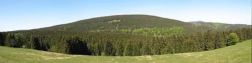
Rehberg Kassandro · CC BY-SA 3.0 -
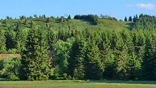
Großer Sonnenberg Kassandro · CC BY-SA 3.0


Climate of Silberhütte
Best months for sightseeingBest months for sightseeing: June–August.
This month · November
A wet month
Day 6° · Night 1° · Rain 134 mm
- Hottest month
- August (day 20°)
- Coldest month
- January (night -3°)
- Wettest month
- December (160 mm)
- Driest month
- May (79 mm)
Bars: average monthly low and high temperature. Below: precipitation. Monthly averages for 1970–2000 at about 18 km resolution, adjusted for elevation. Highlighted months are mild and relatively dry. Source: WorldClim 2.1 (CC BY 4.0).
Show values as a table
| Month | Jan | Feb | Mar | Apr | May | Jun | Jul | Aug | Sep | Oct | Nov | Dec |
|---|---|---|---|---|---|---|---|---|---|---|---|---|
| Average high (°C) | 2° | 3° | 5° | 9° | 15° | 18° | 20° | 20° | 16° | 11° | 6° | 3° |
| Average low (°C) | -3° | -3° | -1° | 2° | 7° | 10° | 12° | 12° | 9° | 5° | 1° | -1° |
| Precipitation (mm) | 141 | 101 | 129 | 89 | 79 | 111 | 106 | 97 | 101 | 115 | 134 | 160 |
How to get to Silberhütte
The nearest airport is Kassel Airport (KSF), 83 km to the west as the crow flies. The nearest large city is Göttingen, 43 km to the southwest.
Airports
- Kassel Airport (KSF) Calden 83 kmwest
- Erfurt-Weimar Airport (ERF) Erfurt 86 kmsouth
- Hannover Airport (HAJ) Hannover 102 kmnorthwest
Nearby large cities
- Göttingen Population: 122.1K 43 kmsouthwest
- Salzgitter Population: 105K 52 kmnorth
- Braunschweig Population: 244.7K 64 kmnorth
- Kassel Population: 197.2K 81 kmsouthwest
- Wolfsburg Population: 123.1K 83 kmnorth
Straight-line distances; road distances are longer. Airport data: OurAirports.
Day trips from Silberhütte
Within 100 km: 503 historic and cultural sites, 4,149 natural sites, 807 lakes, rivers and coasts.
0–25 km632 places
- Schalk River 16 kmN
- Bere River 24 kmSE
- Zillerbachtalsperre Lake 21 kmNE
- Unter Hahnebalzer Teich Lake 17 kmNW
25–60 km1,813 places
- Aue River 44 kmNE
- Aue River 37 kmNE
- Tietal Lake 57 kmNE
- Talsperre Wendefurth Lake 28 kmE
60–100 km3,014 places
- Buchenwald concentration camp Historic site 91 kmSE
- Wiehe River 98 kmN
- Sarre River 68 kmNE
- Ohe River 76 kmNW
Straight-line distances.
Nearby attractions & nature
Everything nearby-
Glocken-Berg Mountain, Lower Saxony1.1 km NE
-
Kleiner Eschenberg Mountain, Lower Saxony1.6 km SE
-
Kuppe Mountain, Braunlage2.5 km N
-
Großer Eschenberg Mountain, Lower Saxony2.5 km S
-
Sieberberg Mountain, Lower Saxony2.3 km N
-
Jordanshöhe Mountain, Braunlage3.2 km NE
Other cities and towns in Braunlage
-
 Königskrug Village, Braunlage7.5 km NE
-
Hohegeiß Village, Braunlage12 km E
Sources & licences
Data last updated: · 2 independent sources