- Elevation
- 45 m
- above sea level
- Airports
- HAM Hamburg Helmut Schmidt Airport50 km
- LBC Lübeck Blankensee Airport77 km
About Lindenberg
Lindenberg is a mountain. Location: Eyendorf, Landkreis Harburg. Elevation: 45 m. The best months to visit are June–August. The nearest airport is Hamburg Helmut Schmidt Airport (50 km). Nearby sights include Schmersberg and Gallerberg.
Photos of Lindenberg
-
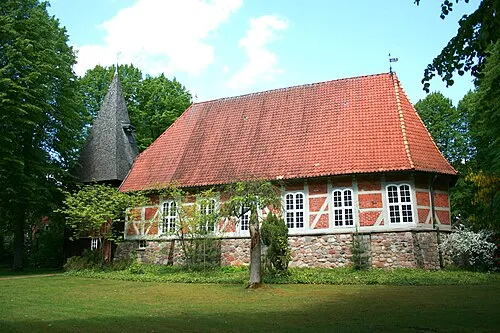
St. Stephanus Frank Vincentz · CC BY-SA 3.0

Climate of Lindenberg
Best months for sightseeingBest months for sightseeing: June–August.
This month · November
A cold month
Day 7° · Night 2° · Rain 59 mm
- Hottest month
- August (day 22°)
- Coldest month
- January (night -2°)
- Wettest month
- June (70 mm)
- Driest month
- February (41 mm)
Bars: average monthly low and high temperature. Below: precipitation. Monthly averages for 1970–2000 at about 18 km resolution, adjusted for elevation. Highlighted months are mild and relatively dry. Source: WorldClim 2.1 (CC BY 4.0).
Show values as a table
| Month | Jan | Feb | Mar | Apr | May | Jun | Jul | Aug | Sep | Oct | Nov | Dec |
|---|---|---|---|---|---|---|---|---|---|---|---|---|
| Average high (°C) | 3° | 4° | 8° | 12° | 18° | 20° | 22° | 22° | 18° | 13° | 7° | 5° |
| Average low (°C) | -2° | -2° | 1° | 3° | 7° | 11° | 13° | 12° | 9° | 5° | 2° | 0° |
| Precipitation (mm) | 58 | 41 | 53 | 46 | 52 | 70 | 67 | 60 | 59 | 53 | 59 | 65 |
How to get to Lindenberg
The nearest airport is Hamburg Helmut Schmidt Airport (HAM), 50 km to the north as the crow flies. The nearest large city is Lübeck, 82 km to the northeast.
Airports
- Hamburg Helmut Schmidt Airport (HAM) Hamburg 50 kmnorth
- Lübeck Blankensee Airport (LBC) Lübeck 77 kmnortheast
- Hannover Airport (HAJ) Hannover 88 kmsouth
Nearby large cities
- Lübeck Population: 212.2K 82 kmnortheast
- Bremen Population: 546.5K 93 kmwest
- Wolfsburg Population: 123.1K 95 kmsoutheast
- Hanover Population: 515.1K 97 kmsouth
- Braunschweig Population: 244.7K 106 kmsouth
Straight-line distances; road distances are longer. Airport data: OurAirports.
Day trips from Lindenberg
Within 100 km: 411 historic and cultural sites, 2,975 natural sites, 1,042 lakes, rivers and coasts.
0–25 km390 places
- Brunausee Lake 17 kmSW
- Flüggenhofsee Lake 23 kmS
- Order See Lake 24 kmNE
- Lopausee Lake 8 kmSE
25–60 km1,581 places
- Viertbusch Natural site 37 kmN
- Sundern Natural site 53 kmSW
- Warnau River 51 kmSW
- Hanskalbsand Island 52 kmNW
60–100 km2,457 places
- Ziegelwerder Island 99 kmNE
- Wiehe River 70 kmS
- Leine River 66 kmSW
- Aubek River 99 kmN
Straight-line distances.
Nearest towns and villages
-
Eyendorf Village, Eyendorf1.5 km NW
-
Salzhausen Village, Salzhausen3 km N
-
Salzhausen Village, Landkreis Harburg4.1 km N
-
Putensen Village, Salzhausen1.5 km E
-
Gödenstorf Village, Landkreis Harburg5 km NW
-
Gödenstorf Village, Gödenstorf5 km NW
Nearby attractions & nature
Everything nearby-
Schmersberg Mountain, Soderstorf1.3 km S
-
Gallerberg Mountain, Salzhausen2.1 km N
-
Märtenberg Mountain, Eyendorf2.9 km SW
-
Heidberg Mountain, Soderstorf3.3 km SW
-
Jägerberg Mountain, Eyendorf3.4 km W
-
Spann Natural site, Gödenstorf3.3 km W
-
Stiepelsberg Mountain, Salzhausen4.6 km N
-
Eichberg Mountain, Oldendorf (Luhe)4.1 km E
Sources & licences
Data last updated: