- Elevation
- 73 m
- above sea level
- Local time
- UTC+01:00
- Europe/Berlin · UTC+01:00
- Airports
- HAJ Hannover Airport60 km
- HAM Hamburg Helmut Schmidt Airport72 km
About Tiegen
Tiegen is a village. Location: Soltau, Landkreis Heidekreis. Elevation: 73 m. The best months to visit are June–August. The nearest airport is Hannover Airport (60 km). Nearby sights include Mönchenberg and Poggenberg.
Photos of Tiegen
-
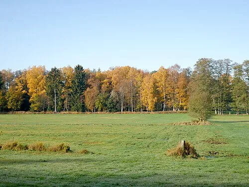
Böhmetal bei Huckenrieth ChristianSW · CC0

Climate of Tiegen
Best months for sightseeingBest months for sightseeing: June–August.
This month · November
A cold month
Day 7° · Night 2° · Rain 68 mm
- Hottest month
- July (day 23°)
- Coldest month
- February (night -2°)
- Wettest month
- December (80 mm)
- Driest month
- February (50 mm)
Bars: average monthly low and high temperature. Below: precipitation. Monthly averages for 1970–2000 at about 18 km resolution, adjusted for elevation. Highlighted months are mild and relatively dry. Source: WorldClim 2.1 (CC BY 4.0).
Show values as a table
| Month | Jan | Feb | Mar | Apr | May | Jun | Jul | Aug | Sep | Oct | Nov | Dec |
|---|---|---|---|---|---|---|---|---|---|---|---|---|
| Average high (°C) | 3° | 4° | 8° | 13° | 19° | 21° | 23° | 23° | 18° | 13° | 7° | 4° |
| Average low (°C) | -2° | -2° | 1° | 3° | 8° | 11° | 13° | 12° | 9° | 6° | 2° | 0° |
| Precipitation (mm) | 71 | 50 | 64 | 52 | 54 | 77 | 67 | 63 | 61 | 60 | 68 | 80 |
How to get to Tiegen
The nearest airport is Hannover Airport (HAJ), 60 km to the south as the crow flies. The nearest large city is Hanover, 69 km to the south.
Airports
- Hannover Airport (HAJ) Hannover 60 kmsouth
- Hamburg Helmut Schmidt Airport (HAM) Hamburg 72 kmnorth
- Bremen Airport (BRE) Bremen 74 kmwest
Nearby large cities
- Hanover Population: 515.1K 69 kmsouth
- Bremen Population: 546.5K 74 kmwest
- Wolfsburg Population: 123.1K 86 kmsoutheast
- Braunschweig Population: 244.7K 91 kmsoutheast
- Salzgitter Population: 105K 99 kmsouth
Straight-line distances; road distances are longer. Airport data: OurAirports.
Day trips from Tiegen
Within 100 km: 403 historic and cultural sites, 2,789 natural sites, 926 lakes, rivers and coasts.
0–25 km336 places
- Sundern Natural site 23 kmSW
- Warnau River 21 kmSW
- Brunausee Lake 15 kmN
- Flüggenhofsee Lake 14 kmE
25–60 km1,335 places
- Wiehe River 54 kmSE
- Leine River 35 kmSW
- Treutsee Lake 49 kmNW
- Reihersee Lake 55 kmNE
60–100 km2,447 places
- Viertbusch Natural site 66 kmNE
- Ohe River 91 kmS
- Rhinplate Island 94 kmN
- Pagensand Island 83 kmN
Straight-line distances.
Nearby attractions & nature
Everything nearby-
Mönchenberg Mountain, Soltau0.3 km NE
-
Poggenberg Mountain, Soltau0.8 km S
-
Bürgerheide Natural site, Lower Saxony1.8 km W
-
Stöhrkreuz Landmark, Soltau3.1 km NW
-
Kleine Aue River, Soltau4.3 km SW
-
felto - Filzwelt Soltau Museum, Soltau3.6 km W
Other cities and towns in Soltau
-
Friedrichseck Village, Soltau3.9 km N
-
Heidenhof Neighbourhood, Soltau4 km N
-
Einfrielingen Village, Soltau4.2 km NW
-
 Deimern Village, Soltau5.3 km N
-
Ahlften Village, Soltau4.4 km NW
-
Hambostel Neighbourhood, Soltau4.6 km N
Sources & licences
Data last updated: