Nordenham
Located in Landkreis Wesermarsch, Lower Saxony Coordinates: 53°29′53″ N 8°27′53″ E

- Population
- 25,889
- 25.9K
- Elevation
- -2 m
- above sea level
- Local time
- UTC+01:00
- Europe/Berlin · UTC+01:00
- Places inside
- 49
- listed under Nordenham
- Airports
- FCN Sea-Airport Cuxhaven/Nordholz / Nordholz Naval Airbase33 km
- BRE Bremen Airport55 km
About Nordenham
Nordenham is a village. Location: Landkreis Wesermarsch, Lower Saxony. Population: 25,889. Elevation: -2 m.
Nordenham (German pronunciation: [nɔʁdn̩ˈham] ) is a town in the Wesermarsch district, in Lower Saxony, Germany. It is located at the mouth (on the west bank) of the Weser river on the Butjadingen peninsula on the coast of the North Sea. The seaport city of Bremerhaven is located on the other side (east bank) of the river. The Midgard-seaport in Nordenham is the largest private-owned harbor in Germany.
Source: Wikipedia · CC BY-SA 4.0
Photos of Nordenham
-
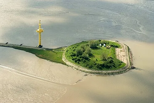
Langlütjen I Martina Nolte · CC BY-SA 3.0 de

Twin towns and sister cities of Nordenham
- Peterlee· United Kingdom
Source: Wikidata. Only places with a page on this site are shown.
Population of Nordenham over time
| 2015 | 26,325 | |
|---|---|---|
| 2016 | 26,294 | |
| 2017 | 26,230 | |
| 2019 | 26,193 | |
| 2021 | 25,959 | |
| 2022 | 26,308 | |
| 2023 | 26,410 | |
| 2024 | 25,889 | |
| 2025 | 25,759 |
Censuses and official estimates; source: Wikidata.
Climate of Nordenham
Best months for sightseeingBest months for sightseeing: June–August.
This month · November
A cold month
Day 8° · Night 3° · Rain 72 mm
- Hottest month
- August (day 21°)
- Coldest month
- January (night -1°)
- Wettest month
- July (76 mm)
- Driest month
- February (37 mm)
Bars: average monthly low and high temperature. Below: precipitation. Monthly averages for 1970–2000 at about 18 km resolution, adjusted for elevation. Highlighted months are mild and relatively dry. Source: WorldClim 2.1 (CC BY 4.0).
Show values as a table
| Month | Jan | Feb | Mar | Apr | May | Jun | Jul | Aug | Sep | Oct | Nov | Dec |
|---|---|---|---|---|---|---|---|---|---|---|---|---|
| Average high (°C) | 4° | 4° | 8° | 11° | 16° | 19° | 21° | 21° | 17° | 13° | 8° | 5° |
| Average low (°C) | -1° | -1° | 2° | 4° | 8° | 11° | 13° | 13° | 10° | 7° | 3° | 1° |
| Precipitation (mm) | 58 | 37 | 51 | 45 | 56 | 75 | 76 | 68 | 67 | 63 | 72 | 66 |
How to get to Nordenham
The nearest airport is Sea-Airport Cuxhaven/Nordholz / Nordholz Naval Airbase (FCN), 33 km to the northeast as the crow flies. For international flights: Bremen Airport (BRE) (55 km). The nearest large city is Bremerhaven, 10 km to the northeast.
Airports
- Sea-Airport Cuxhaven/Nordholz / Nordholz Naval Airbase (FCN) Wurster Nordseeküste 33 kmnortheast
- Bremen Airport (BRE) Bremen 55 kmsoutheast
- Hamburg Helmut Schmidt Airport (HAM) Hamburg 102 kmeast
Nearby large cities
- Bremerhaven Population: 118.6K 10 kmnortheast
- Oldenburg Population: 159.2K 43 kmsouthwest
- Bremen Population: 546.5K 52 kmsoutheast
- Groningen Population: 244.8K 130 kmwest
- Osnabrück Population: 166.5K 139 kmsouth
Straight-line distances; road distances are longer. Airport data: OurAirports.
Day trips from Nordenham
Within 100 km: 241 historic and cultural sites, 1,043 natural sites, 797 lakes, rivers and coasts.
0–25 km118 places
- Friesenstrand Beach 17 kmNW
- Harrier Sand Island 21 kmS
- Langlütjen II Island 9 kmN
- Sellstedter See Lake 17 kmE
25–60 km682 places
- Insel Spiekeroog Island 59 kmNW
- Strand Harlesiel Beach 50 kmNW
- Nordstrand Beach 59 kmNW
- Neuwerk Island 47 kmN
60–100 km1,281 places
- East Frisian Islands Island 74 kmW
- Norderney Island 84 kmW
- Baltrum Island 75 kmW
- Juist Island 99 kmW
Straight-line distances.
Places in Nordenham
49 placesBar: population relative to the most populous place in this list.
Cities & villages46
- Abbehausen · Village
- Abbehausergroden · Village
- Abbehauser Wehl · Village
- Abbehauserwisch · Village
- Atens · Village
- Atenseraltensiel · Village
- Blexen · Village
- Blexerdeich · Village
- Blexersande · Village
- Blexerwurp · Village
- Bulterweg · Village
- Büttelersiel · Village
- Butterburg · Village
- Einswarden · Neighbourhood
- Ellwürden · Village
- Enjebuhr · Village
- Esenshamm · Village
- Esenshammergroden · Village
- Esenshammer Oberdeich · Village
- Friedrich-August-Hütte · Neighbourhood
- Grebswarden · Village
- Großensiel · Village
- Hasennest · Village
- Havendorf · Village
- Heering · Village
- Hoffe · Village
- Kloster · Village
- Kollerei · Village
- Kurfürstendamm · Village
- Langenriep · Village
- Mitteldeich · Village
- Moorsee · Village
- Neuenhoben · Village
- Osterseefeld · Village
- Phiesewarden · Village
- Rahden · Village
- Sarve · Village
- Schneewarden · Village
- Schockumerdeich · Village
- Schütting · Village
- Schweimer · Village
- Tettens · Village
- Tettensersiel · Village
- Treuenfeld · Village
- Twistern · Village
- Volkers · Village
Lakes, rivers & coasts1
- Langlütjen I · Island
Heritage & sights1
- Early Camp Bremerhaven-Langlütjen II · Historic site
Nearby attractions & nature
Everything nearby-
Utergadinger Sieltief River, Lower Saxony3.3 km S
-
Alte Weser River, Lower Saxony3.2 km SE
-
Naturschutzgebiet Luneplate Natural site, Free Hanseatic City of Bremen5 km E
-
Butjadingen Natural site, Lower Saxony6.5 km NW
-
Dedesdorfer Sieltief River, Loxstedt6.1 km S
-
Lune River, Free Hanseatic City of Bremen6.6 km E
Sources & licences
Data last updated: · 2 independent sources