Eilvese
Located in Neustadt am Rübenberge, Region Hannover Coordinates: 52°32′47″ N 9°24′56″ E
- Elevation
- 46 m
- above sea level
- Local time
- UTC+01:00
- Europe/Berlin · UTC+01:00
- Airports
- HAJ Hannover Airport21 km
- BRE Bremen Airport70 km
About Eilvese
Eilvese is a village. Location: Neustadt am Rübenberge, Region Hannover. Elevation: 46 m.
Eilvese is a borough of Neustadt am Rübenberge in the district of Hanover, Lower Saxony in Germany. It had a population of 1626 in 2021.
Source: Wikipedia · CC BY-SA 4.0
At a glance
- Area
- 16.6 km²
Source: Wikidata
Photos of Eilvese
-
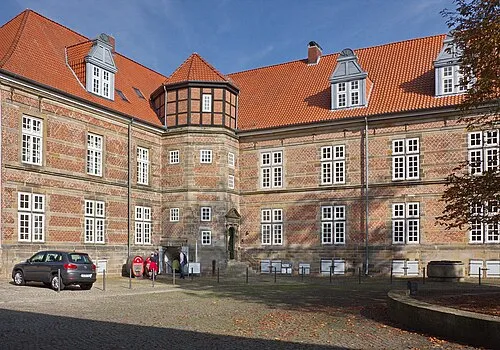
Landestrost Castle Losch · CC BY-SA 4.0

Climate of Eilvese
Best months for sightseeingBest months for sightseeing: June–August.
This month · November
A cold month
Day 8° · Night 2° · Rain 58 mm
- Hottest month
- August (day 23°)
- Coldest month
- February (night -2°)
- Wettest month
- June (73 mm)
- Driest month
- February (44 mm)
Bars: average monthly low and high temperature. Below: precipitation. Monthly averages for 1970–2000 at about 18 km resolution, adjusted for elevation. Highlighted months are mild and relatively dry. Source: WorldClim 2.1 (CC BY 4.0).
Show values as a table
| Month | Jan | Feb | Mar | Apr | May | Jun | Jul | Aug | Sep | Oct | Nov | Dec |
|---|---|---|---|---|---|---|---|---|---|---|---|---|
| Average high (°C) | 4° | 5° | 8° | 13° | 18° | 21° | 23° | 23° | 19° | 13° | 8° | 5° |
| Average low (°C) | -1° | -2° | 1° | 3° | 7° | 10° | 12° | 12° | 9° | 6° | 2° | 0° |
| Precipitation (mm) | 61 | 44 | 56 | 46 | 51 | 73 | 65 | 66 | 57 | 57 | 58 | 69 |
How to get to Eilvese
The nearest airport is Hannover Airport (HAJ), 21 km to the southeast as the crow flies. The nearest large city is Hanover, 29 km to the southeast.
Airports
- Hannover Airport (HAJ) Hannover 21 kmsoutheast
- Bremen Airport (BRE) Bremen 70 kmnorthwest
- Paderborn Lippstadt Airport (PAD) Büren 117 kmsouthwest
Nearby large cities
- Hanover Population: 515.1K 29 kmsoutheast
- Bremen Population: 546.5K 72 kmnorthwest
- Salzgitter Population: 105K 81 kmsoutheast
- Braunschweig Population: 244.7K 82 kmeast
- Bielefeld Population: 331.9K 83 kmsouthwest
Straight-line distances; road distances are longer. Airport data: OurAirports.
Day trips from Eilvese
Within 100 km: 325 historic and cultural sites, 2,932 natural sites, 793 lakes, rivers and coasts.
0–25 km243 places
- Leine River 23 kmNE
- Badeinsel Island 10 kmS
- Lake Steinhude Lake 10 kmSW
- Rothenküler Teich Lake 15 kmS
25–60 km987 places
- Sundern Natural site 36 kmNE
- Warnau River 40 kmN
- Ohe River 46 kmSE
- Maschsee Lake 31 kmSE
60–100 km2,820 places
- Wiehe River 62 kmE
- Grimke River 98 kmSW
- Elsflether Sand Island 99 kmNW
- Goten Lake 98 kmW
Straight-line distances.
Nearby attractions & nature
Everything nearby-
Uhlenberg Mountain, Neustadt am Rübenberge1.9 km W
-
Langberg Mountain, Neustadt am Rübenberge2 km E
-
Tannenbruch Natural site, Lower Saxony1.4 km SE
-
Masekersberg Mountain, Neustadt am Rübenberge2.3 km NW
-
Brand Mountain, Neustadt am Rübenberge2.7 km NW
-
Kampenbusch Natural site, Neustadt am Rübenberge2.6 km SE
Sources & licences
Data last updated: · 2 independent sources