Sprengersfelde
Located in Ferdinandshof, Vorpommern-Greifswald Coordinates: 53°41′17″ N 13°54′00″ E
- Elevation
- 6 m
- above sea level
- Local time
- UTC+01:00
- Europe/Berlin · UTC+01:00
- Airports
- HDF Heringsdorf Airport27 km
- SZZ Solidarity Szczecin–Goleniów Airport67 km
About Sprengersfelde
Sprengersfelde is a village. Location: Ferdinandshof, Vorpommern-Greifswald. Elevation: 6 m. The best months to visit are June–August. The nearest airport is Heringsdorf Airport (27 km). Nearby sights include Forst Jädkemühl and Naturpark Am Stettiner Haff.
Climate of Sprengersfelde
Best months for sightseeingBest months for sightseeing: June–August.
This month · November
A cold month
Day 7° · Night 2° · Rain 41 mm
- Hottest month
- July (day 22°)
- Coldest month
- January (night -3°)
- Wettest month
- July (62 mm)
- Driest month
- February (29 mm)
Bars: average monthly low and high temperature. Below: precipitation. Monthly averages for 1970–2000 at about 18 km resolution, adjusted for elevation. Highlighted months are mild and relatively dry. Source: WorldClim 2.1 (CC BY 4.0).
Show values as a table
| Month | Jan | Feb | Mar | Apr | May | Jun | Jul | Aug | Sep | Oct | Nov | Dec |
|---|---|---|---|---|---|---|---|---|---|---|---|---|
| Average high (°C) | 2° | 3° | 7° | 11° | 17° | 20° | 22° | 22° | 18° | 13° | 7° | 4° |
| Average low (°C) | -3° | -2° | 0° | 3° | 7° | 11° | 13° | 13° | 9° | 6° | 2° | -1° |
| Precipitation (mm) | 37 | 29 | 36 | 32 | 52 | 60 | 62 | 60 | 49 | 40 | 41 | 40 |
How to get to Sprengersfelde
The nearest airport is Heringsdorf Airport (HDF), 27 km to the northeast as the crow flies. For international flights: Solidarity Szczecin–Goleniów Airport (SZZ) (67 km). The nearest large city is Rostock, 124 km to the west.
Airports
- Heringsdorf Airport (HDF) Zirchow 27 kmnortheast
- Solidarity Szczecin–Goleniów Airport (SZZ) Szczecin(Glewice) 67 kmeast
- Rostock-Laage Airport (RLG) Laage 110 kmwest
Nearby large cities
- Rostock Population: 198.3K 124 kmwest
- Berlin Population: 3.4M 134 kmsouth
- Potsdam Population: 184.8K 154 kmsouth
- Lübeck Population: 212.2K 213 kmwest
- Malmö Population: 362.1K 221 kmnorth
Straight-line distances; road distances are longer. Airport data: OurAirports.
Day trips from Sprengersfelde
Within 100 km: 194 historic and cultural sites, 1,585 natural sites, 1,210 lakes, rivers and coasts.
0–25 km162 places
- Beeke River 24 kmE
- Usedomer See Lake 19 kmN
- Stadtsee Lake 23 kmSW
- Schwarzer See Lake 22 kmN
25–60 km883 places
- Ruden Island 58 kmN
- Usedom Island Island 30 kmNE
- Wolin Island 47 kmNE
- Insel Görmitz Island 37 kmN
60–100 km1,944 places
- Ummanz Island 99 kmNW
- Greifswalder Oie Island 62 kmN
- Vilm Island 74 kmN
- Koos Island 63 kmNW
Straight-line distances.
Nearby attractions & nature
Everything nearby-
Forst Jädkemühl Natural site, Mecklenburg-Vorpommern4.6 km E
-
Naturpark Am Stettiner Haff Natural site, Liepgarten5.4 km E
-
Stargordtsche Forst Natural site, Mecklenburg-Vorpommern5.2 km N
-
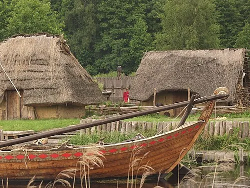 Ukranenland Museum, Torgelow10 km SE
-
Hoher Mittagsberg Mountain, Wilhelmsburg10 km S
-
Apothekerberg Mountain, Liepgarten8.3 km NE
Sources & licences
Data last updated: