Gützkow
Located in Vorpommern-Greifswald, Mecklenburg-Vorpommern Coordinates: 53°57′00″ N 13°25′00″ E
- Population
- 3,034
- 3K
- Elevation
- 13 m
- above sea level
- Local time
- UTC+01:00
- Europe/Berlin · UTC+01:00
- Places inside
- 18
- listed under Gützkow
- Airports
- HDF Heringsdorf Airport49 km
- RLG Rostock-Laage Airport75 km
About Gützkow
Gützkow is a village. Location: Vorpommern-Greifswald, Mecklenburg-Vorpommern. Population: 3,034. Elevation: 13 m.
Gützkow (German pronunciation: [ˈɡʏtskoː] ) is a town in the District of Vorpommern-Greifswald in Mecklenburg-Vorpommern, in north-eastern Germany. It is situated some 15 kilometres (9.3 mi) south of Greifswald, on the north bank of the River Peene. Gützkow was the central town of the medieval County of Gützkow.
Source: Wikipedia · CC BY-SA 4.0
Twin towns and sister cities of Gützkow
- Bohmte· Germany
Source: Wikidata. Only places with a page on this site are shown.
Population of Gützkow over time
| 2013 | 2,794 | |
|---|---|---|
| 2017 | 3,021 | |
| 2019 | 2,965 | |
| 2021 | 2,923 | |
| 2022 | 2,974 | |
| 2023 | 2,955 | |
| 2024 | 3,034 | |
| 2025 | 2,965 |
Censuses and official estimates; source: Wikidata.
Climate of Gützkow
Best months for sightseeingBest months for sightseeing: June–August.
This month · November
A cold month
Day 7° · Night 2° · Rain 45 mm
- Hottest month
- August (day 22°)
- Coldest month
- January (night -3°)
- Wettest month
- August (65 mm)
- Driest month
- February (32 mm)
Bars: average monthly low and high temperature. Below: precipitation. Monthly averages for 1970–2000 at about 18 km resolution, adjusted for elevation. Highlighted months are mild and relatively dry. Source: WorldClim 2.1 (CC BY 4.0).
Show values as a table
| Month | Jan | Feb | Mar | Apr | May | Jun | Jul | Aug | Sep | Oct | Nov | Dec |
|---|---|---|---|---|---|---|---|---|---|---|---|---|
| Average high (°C) | 2° | 3° | 7° | 11° | 17° | 20° | 22° | 22° | 18° | 13° | 7° | 4° |
| Average low (°C) | -3° | -2° | 0° | 3° | 7° | 10° | 12° | 12° | 9° | 6° | 2° | -1° |
| Precipitation (mm) | 39 | 32 | 40 | 33 | 51 | 58 | 59 | 65 | 51 | 44 | 45 | 41 |
How to get to Gützkow
The nearest airport is Heringsdorf Airport (HDF), 49 km to the east as the crow flies. For international flights: Solidarity Szczecin–Goleniów Airport (SZZ) (106 km). The nearest large city is Rostock, 85 km to the west.
Airports
- Heringsdorf Airport (HDF) Zirchow 49 kmeast
- Rostock-Laage Airport (RLG) Laage 75 kmwest
- Solidarity Szczecin–Goleniów Airport (SZZ) Szczecin(Glewice) 106 kmeast
Nearby large cities
- Rostock Population: 198.3K 85 kmwest
- Berlin Population: 3.4M 159 kmsouth
- Potsdam Population: 184.8K 174 kmsouth
- Lübeck Population: 212.2K 180 kmwest
- Malmö Population: 362.1K 186 kmnorth
Straight-line distances; road distances are longer. Airport data: OurAirports.
Day trips from Gützkow
Within 100 km: 188 historic and cultural sites, 1,856 natural sites, 1,222 lakes, rivers and coasts.
0–25 km175 places
- Koos Island 25 kmN
- Lubminer Strand Beach 25 kmNE
- Kleiner Werder Island 25 kmN
- Schwarzer See Lake 15 kmNE
25–60 km964 places
- Ruden Island 37 kmNE
- Usedom Island Island 44 kmE
- Insel Görmitz Island 34 kmE
- Greifswalder Oie Island 46 kmNE
60–100 km2,127 places
- Wolin Island 71 kmE
- Hiddensee Island 69 kmN
- Ummanz Island 60 kmN
- Beeke River 63 kmSE
Straight-line distances.
Places in Gützkow
18 places


Cities & villages7
Mountains & nature5
- Kuckucksberg · Mountain
- Naturschutzgebiet Peenetal · Natural site
- Naturschutzgebiet Peenewiesen · Natural site
- Spitzberg · Mountain
- Totenberg · Mountain
Nearby attractions & nature
Everything nearby-
Kosenowsee Lake, Mecklenburg-Vorpommern2.2 km SE
-
Swinowbach River, Mecklenburg-Vorpommern3.9 km S
-
Behrenhoff, Dorfkirche Attraction, Behrenhoff6.4 km N
-
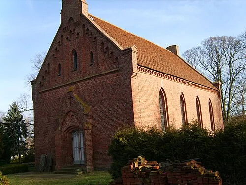 Dorfkirche Quilow Attraction, Groß Polzin12 km SE
-
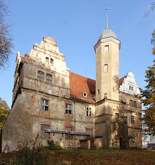 Wasserschloss Quilow Historic site, Groß Polzin12 km SE
-
Sanzer Forst Natural site, Mecklenburg-Vorpommern7.7 km N
Other cities and towns in Vorpommern-Greifswald
-
 Ranzin Village, Züssow7.3 km E
-
 Behrenhoff Village, Behrenhoff6.4 km N
-
Schmoldow Village, Bandelin4.8 km NW
-
Kagenow Village, Neetzow-Liepen5.5 km S
Sources & licences
Data last updated: · 2 independent sources