- Elevation
- 375 m
- above sea level
- Local time
- UTC+01:00
- Europe/Berlin · UTC+01:00
- Airports
- CGN Cologne Bonn Airport31 km
- DTM Dortmund Airport58 km
About Burgberg
Burgberg is a mountain. Location: Gummersbach, Oberbergischer Kreis. Elevation: 375 m. The best months to visit are June–August. The nearest airport is Cologne Bonn Airport (31 km). Nearby sights include Stahlberg and Eckkopf.
Photos of Burgberg
-
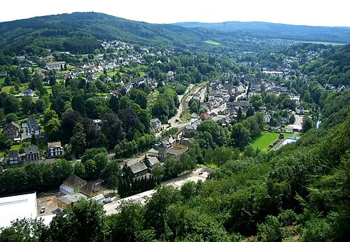
Hohe Warte Guido Schmickler · CC BY-SA 2.5

Climate of Burgberg
Best months for sightseeingBest months for sightseeing: June–August.
This month · November
A wet month
Day 7° · Night 1° · Rain 109 mm
- Hottest month
- July (day 22°)
- Coldest month
- February (night -3°)
- Wettest month
- December (126 mm)
- Driest month
- April (73 mm)
Bars: average monthly low and high temperature. Below: precipitation. Monthly averages for 1970–2000 at about 18 km resolution, adjusted for elevation. Highlighted months are mild and relatively dry. Source: WorldClim 2.1 (CC BY 4.0).
Show values as a table
| Month | Jan | Feb | Mar | Apr | May | Jun | Jul | Aug | Sep | Oct | Nov | Dec |
|---|---|---|---|---|---|---|---|---|---|---|---|---|
| Average high (°C) | 3° | 4° | 8° | 12° | 17° | 19° | 22° | 21° | 17° | 12° | 7° | 4° |
| Average low (°C) | -2° | -3° | 0° | 2° | 6° | 9° | 11° | 11° | 8° | 5° | 1° | -1° |
| Precipitation (mm) | 117 | 84 | 104 | 73 | 78 | 93 | 99 | 78 | 90 | 92 | 109 | 126 |
How to get to Burgberg
The nearest airport is Cologne Bonn Airport (CGN), 31 km to the southwest as the crow flies. The nearest large city is Bergisch Gladbach, 28 km to the west.
Airports
- Cologne Bonn Airport (CGN) Köln (Cologne) 31 kmsouthwest
- Dortmund Airport (DTM) Dortmund 58 kmnorth
- Düsseldorf Airport (DUS) Düsseldorf 63 kmnorthwest
Nearby large cities
- Bergisch Gladbach Population: 106.2K 28 kmwest
- Remscheid Population: 117.1K 31 kmnorthwest
- Solingen Population: 164.4K 37 kmnorthwest
- Siegen Population: 107.2K 37 kmeast
- Leverkusen Population: 162.7K 39 kmwest
Straight-line distances; road distances are longer. Airport data: OurAirports.
Day trips from Burgberg
Within 100 km: 592 historic and cultural sites, 3,718 natural sites, 866 lakes, rivers and coasts.
0–25 km183 places
- Versetalsperre Lake 23 kmNE
- Neyetalsperre Lake 18 kmNW
- Lister Talsperre Lake 23 kmNE
- Lingesetalsperre Lake 12 kmN
25–60 km1,550 places
- Else River 49 kmN
- Else River 35 kmNE
- Weibe River 27 kmSE
- Urbach River 53 kmS
60–100 km3,443 places
- Iterbach River 99 kmW
- Olef River 87 kmSW
- Valme River 73 kmNE
- Ohe River 85 kmE
Straight-line distances.
Nearest towns and villages
-
Lobscheid Village, Gummersbach0.8 km NW
-
 Liefenroth Village, Gummersbach1 km NE
-
Vollmerhausen Village, Gummersbach1.2 km SE
-
Dieringhausen Village, Gummersbach1.5 km S
-
 Brunohl Village, Gummersbach1.7 km W
-
Bünghausen Village, Gummersbach1.9 km SW
Nearby attractions & nature
Everything nearby-
Stahlberg Mountain, Gummersbach0.9 km E
-
Eckkopf Mountain, Gummersbach1.6 km N
-
Lopscheid Mountain, Gummersbach3.3 km NW
-
Zimmerberg Mountain, Gummersbach3.5 km NW
-
Sessmarbach River, North Rhine-Westphalia2.5 km E
-
Hohe Warte Mountain, Engelskirchen5.1 km W
-
Kerrberg Mountain, Gummersbach4.9 km NE
-
Gummershardt Mountain, Gummersbach5 km N
More nature in Germany
Sources & licences
Data last updated: · 2 independent sources