- Elevation
- 137 m
- above sea level
- Local time
- UTC+01:00
- Europe/Berlin · UTC+01:00
- Airports
- CGN Cologne Bonn Airport38 km
- DTM Dortmund Airport83 km
About Au
Au is a village. Location: Windeck, Rhein-Sieg-Kreis. Elevation: 137 m. The best months to visit are June–August. The nearest airport is Cologne Bonn Airport (38 km). Nearby sights include Irsenbach and Löschbach.
Photos of Au
-
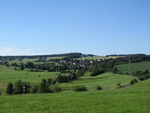
Beulskopf Jörg Braukmann · CC BY 3.0

Climate of Au
Best months for sightseeingBest months for sightseeing: June–August.
This month · November
A cold month
Day 8° · Night 3° · Rain 95 mm
- Hottest month
- July (day 23°)
- Coldest month
- February (night -1°)
- Wettest month
- December (111 mm)
- Driest month
- April (67 mm)
Bars: average monthly low and high temperature. Below: precipitation. Monthly averages for 1970–2000 at about 18 km resolution, adjusted for elevation. Highlighted months are mild and relatively dry. Source: WorldClim 2.1 (CC BY 4.0).
Show values as a table
| Month | Jan | Feb | Mar | Apr | May | Jun | Jul | Aug | Sep | Oct | Nov | Dec |
|---|---|---|---|---|---|---|---|---|---|---|---|---|
| Average high (°C) | 4° | 6° | 9° | 14° | 19° | 21° | 23° | 23° | 19° | 14° | 8° | 5° |
| Average low (°C) | -1° | -1° | 2° | 4° | 8° | 11° | 13° | 12° | 9° | 6° | 3° | 1° |
| Precipitation (mm) | 99 | 76 | 92 | 67 | 76 | 87 | 91 | 73 | 82 | 85 | 95 | 111 |
How to get to Au
The nearest airport is Cologne Bonn Airport (CGN), 38 km to the west as the crow flies. The nearest large city is Siegen, 28 km to the northeast.
Airports
- Cologne Bonn Airport (CGN) Köln (Cologne) 38 kmwest
- Dortmund Airport (DTM) Dortmund 83 kmnorth
- Düsseldorf Airport (DUS) Düsseldorf 85 kmnorthwest
Nearby large cities
- Siegen Population: 107.2K 28 kmnortheast
- Bonn Population: 330.6K 40 kmwest
- Bergisch Gladbach Population: 106.2K 44 kmnorthwest
- Koblenz Population: 107.3K 47 kmsouth
- Cologne Population: 1M 53 kmwest
Straight-line distances; road distances are longer. Airport data: OurAirports.
Day trips from Au
Within 100 km: 748 historic and cultural sites, 4,178 natural sites, 872 lakes, rivers and coasts.
0–25 km185 places
- Weibe River 19 kmNE
- Dreifelder Weiher Lake 23 kmSE
- Wiehltalsperre Lake 19 kmN
- Ziegenberg Mountain 20 kmNE
25–60 km1,965 places
- Else River 53 kmN
- Aar River 51 kmSE
- Urbach River 29 kmS
- Kemper Werth Island 40 kmW
60–100 km3,648 places
- Murringer Wald Natural site 99 kmW
- Dreiherrenwald Natural site 98 kmW
- Olef River 85 kmW
- Else River 74 kmN
Straight-line distances.
Nearby attractions & nature
Everything nearbyOther cities and towns in Windeck


Sources & licences
Data last updated: