- Elevation
- 60 m
- above sea level
- Local time
- UTC+01:00
- Europe/Berlin · UTC+01:00
- Airports
- DTM Dortmund Airport51 km
- DUS Düsseldorf Airport53 km
About Endeln
Endeln is a village. Location: Dorsten, Kreis Recklinghausen. Elevation: 60 m. The best months to visit are June–August. The nearest airport is Dortmund Airport (51 km). Nearby sights include Schloß Lembeck and Naturpark Hohe Mark.
Photos of Endeln
-
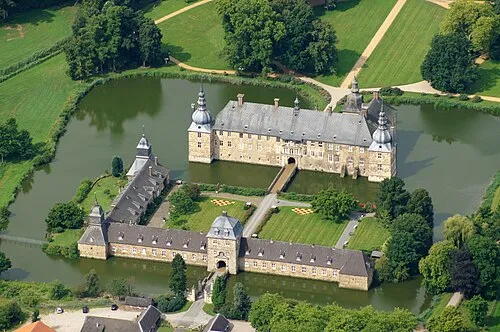
Schloß Lembeck Günter Seggebäing, Coesfeld · CC BY-SA 3.0

Climate of Endeln
Best months for sightseeingBest months for sightseeing: June–August.
This month · November
A cold month
Day 9° · Night 3° · Rain 74 mm
- Hottest month
- July (day 23°)
- Coldest month
- February (night 0°)
- Wettest month
- June (80 mm)
- Driest month
- February (52 mm)
Bars: average monthly low and high temperature. Below: precipitation. Monthly averages for 1970–2000 at about 18 km resolution, adjusted for elevation. Highlighted months are mild and relatively dry. Source: WorldClim 2.1 (CC BY 4.0).
Show values as a table
| Month | Jan | Feb | Mar | Apr | May | Jun | Jul | Aug | Sep | Oct | Nov | Dec |
|---|---|---|---|---|---|---|---|---|---|---|---|---|
| Average high (°C) | 5° | 6° | 9° | 13° | 18° | 21° | 23° | 22° | 19° | 14° | 9° | 6° |
| Average low (°C) | 0° | 0° | 2° | 4° | 8° | 11° | 13° | 13° | 10° | 7° | 3° | 1° |
| Precipitation (mm) | 71 | 52 | 67 | 52 | 65 | 80 | 74 | 67 | 74 | 66 | 74 | 80 |
How to get to Endeln
The nearest airport is Dortmund Airport (DTM), 51 km to the southeast as the crow flies. The nearest large city is Recklinghausen, 22 km to the southeast.
Airports
- Dortmund Airport (DTM) Dortmund 51 kmsoutheast
- Düsseldorf Airport (DUS) Düsseldorf 53 kmsouth
- Weeze (Niederrhein) Airport (NRN) Weeze 60 kmwest
Nearby large cities
- Recklinghausen Population: 122.4K 22 kmsoutheast
- Bottrop Population: 119.9K 26 kmsouth
- Gelsenkirchen Population: 270K 29 kmsouth
- Herne Population: 172.1K 29 kmsoutheast
- Oberhausen Population: 219.2K 31 kmsouth
Straight-line distances; road distances are longer. Airport data: OurAirports.
Day trips from Endeln
Within 100 km: 352 historic and cultural sites, 1,082 natural sites, 595 lakes, rivers and coasts.
0–25 km137 places
- Halterner Talsperre Lake 17 kmE
- Waldbeerenberg Mountain 10 kmE
- Vogelberg Mountain 17 kmE
- Tiglersberg Mountain 16 kmW
25–60 km518 places
- Else River 54 kmSE
- Werse River 58 kmNE
- Strang Lake 56 kmW
- Schönwasser Lake 54 kmSW
60–100 km1,374 places
- Putjensberg Mountain 98 kmNW
- Kasteel Arcen Historic site 63 kmSW
- Else River 85 kmSE
- Ahse River 61 kmE
Straight-line distances.
Nearby attractions & nature
Everything nearby-
Schloß Lembeck Historic site, Dorsten2 km SE
-
Naturpark Hohe Mark Natural site, Dorsten2.8 km W
-
Kalter Bach River, North Rhine-Westphalia2.4 km SW
-
Lemberg Mountain, Dorsten5 km NE
-
Kortenberg Mountain, Dorsten5.6 km E
-
Wolfsberg Mountain, Schermbeck4.8 km SW
Other cities and towns in Dorsten
-
 Wulfen Village, Dorsten4.8 km SE
-
 Holsterhausen Village, Dorsten7.8 km S
-
Lasthausen Village, Dorsten2.8 km S
-
Heide Village, Dorsten3.1 km E
-
Höfe Village, Dorsten3.3 km NW
-
Bahnhof Vorhelm Village, Dorsten3.6 km N
Sources & licences
Data last updated: