Altmarkkreis Salzwedel
Located in Saxony-Anhalt, Germany Coordinates: 52°40′00″ N 11°12′00″ E
- Population
- 79,980
- 80K
- Elevation
- 41 m
- above sea level
- Local time
- UTC+01:00
- Europe/Berlin · UTC+01:00
- Places inside
- 13
- listed under Altmarkkreis Salzwedel
- Airports
- HAJ Hannover Airport105 km
- LBC Lübeck Blankensee Airport131 km
About Altmarkkreis Salzwedel
Altmarkkreis Salzwedel is a municipality. Location: Saxony-Anhalt, Germany. Population: 79,980. Elevation: 41 m.
Altmarkkreis Salzwedel is a district in Saxony-Anhalt, Germany. It is bounded by (from the west and clockwise) the districts Gifhorn, Uelzen, Lüchow-Dannenberg in Lower Saxony, and the districts of Stendal and Börde (district).
Source: Wikipedia · CC BY-SA 4.0
Climate of Altmarkkreis Salzwedel
Best months for sightseeingBest months for sightseeing: June–August.
This month · November
A cold month
Day 7° · Night 2° · Rain 43 mm
- Hottest month
- July (day 23°)
- Coldest month
- January (night -2°)
- Wettest month
- July (62 mm)
- Driest month
- February (33 mm)
Bars: average monthly low and high temperature. Below: precipitation. Monthly averages for 1970–2000 at about 18 km resolution, adjusted for elevation. Highlighted months are mild and relatively dry. Source: WorldClim 2.1 (CC BY 4.0).
Show values as a table
| Month | Jan | Feb | Mar | Apr | May | Jun | Jul | Aug | Sep | Oct | Nov | Dec |
|---|---|---|---|---|---|---|---|---|---|---|---|---|
| Average high (°C) | 3° | 4° | 8° | 13° | 19° | 21° | 23° | 23° | 19° | 13° | 7° | 4° |
| Average low (°C) | -2° | -2° | 1° | 3° | 8° | 11° | 13° | 12° | 9° | 5° | 2° | -1° |
| Precipitation (mm) | 42 | 33 | 40 | 38 | 49 | 58 | 62 | 53 | 43 | 40 | 43 | 48 |
How to get to Altmarkkreis Salzwedel
The nearest airport is Hannover Airport (HAJ), 105 km to the west as the crow flies. The nearest large city is Wolfsburg, 39 km to the southwest.
Airports
- Hannover Airport (HAJ) Hannover 105 kmwest
- Lübeck Blankensee Airport (LBC) Lübeck 131 kmnorth
- Hamburg Helmut Schmidt Airport (HAM) Hamburg 134 kmnorthwest
Nearby large cities
- Wolfsburg Population: 123.1K 39 kmsouthwest
- Braunschweig Population: 244.7K 64 kmsouthwest
- Magdeburg Population: 244.3K 66 kmsoutheast
- Salzgitter Population: 105K 78 kmsouthwest
- Hanover Population: 515.1K 105 kmwest
Straight-line distances; road distances are longer. Airport data: OurAirports.
Day trips from Altmarkkreis Salzwedel
Within 100 km: 384 historic and cultural sites, 2,841 natural sites, 702 lakes, rivers and coasts.
0–25 km200 places
- Zißberg Mountain 8 kmSW
- Wasserberg Mountain 6 kmSE
- Trappenberg Mountain 12 kmSW
- Steinberg Mountain 24 kmSE
25–60 km1,023 places
- Zollau Lake 60 kmSE
- Wilckensee Lake 49 kmN
- Vorderbrack Lake 51 kmNE
- Taube Elbe Lake 51 kmNE
60–100 km2,704 places
- Wiehe River 60 kmW
- Sarre River 75 kmS
- Ehle River 62 kmSE
- Ehle River 87 kmS
Straight-line distances.
Altmarkkreis Salzwedel and similar cities
Side by side with cities of similar size in the same country: population, elevation and climate.
| Measure | Altmarkkreis Salzwedel | Arnsberg | Detmold | Bayreuth |
|---|---|---|---|---|
| Population | 80K | 74.9K | 73.7K | 72.9K |
| Elevation | 41 m | 295 m | 135 m | 338 m |
| Summer day (hottest month) | 23° | 21° | 22° | 23° |
| Winter night (coldest month) | -2° | -2° | -1° | -3° |
| Annual rainfall | 549 mm | 1,046 mm | 969 mm | 810 mm |
| Best months | Jun–Aug | Jun–Aug | Jun–Aug | Jun–Aug |
| Distance | — | 257 km | 178 km | 304 km |
Climate values are 1970–2000 monthly averages; straight-line distance.
Places in Altmarkkreis Salzwedel
13 places- 1 Salzwedel 23K
- 2 Gardelegen 21.8K
- 3 Klötze 9.7K
- 4 Kalbe (Milde) 7K
- 5 Arendsee (Altmark) 6.2K
- 6 Beetzendorf 2.9K
- 7 Diesdorf, Flecken 2.1K
- 8 Apenburg-Winterfeld, Flecken 1.7K
- 9 Jübar 1.5K
- 10 Dähre 1.3K
- 11 Kuhfelde 1K
- 12 Rohrberg 964
- 13 Wallstawe 815
Bar: population relative to the most populous place in this list.
Nearby attractions & nature
Everything nearby-
Rittlebener Forst Natural site, Saxony-Anhalt3.2 km NW
-
Bäke River, Saxony-Anhalt4.9 km E
-
Jemmeritzer Heide Natural site, Saxony-Anhalt6.5 km SE
-
Klötzer Forst Natural site, Saxony-Anhalt6.8 km S
-
Schwiesauer Heide Natural site, Saxony-Anhalt6.8 km SE
-
Winkelstedter Holz Natural site, Saxony-Anhalt6.8 km E
-
Mühlenberg Mountain, Saxony-Anhalt8.7 km NE
-
Parchen Natural site, Saxony-Anhalt9.6 km NE
Other cities and towns in Saxony-Anhalt
-
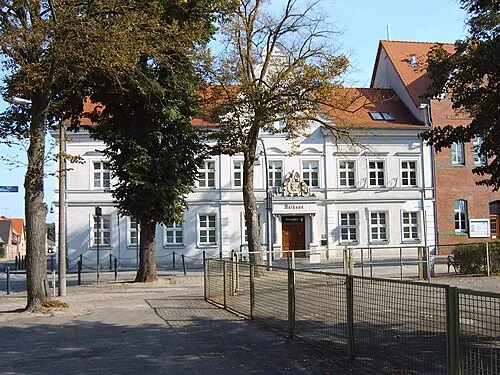 Klötze Town, Klötze4.8 km SW
-
Jerichower Land Municipality, Saxony-Anhalt70 km SE
-
Landkreis Stendal Municipality, Saxony-Anhalt45 km E
-
Hansestadt Salzwedel Town, Salzwedel21 km N
-
Gardelegen Town, Gardelegen21 km SE
-
Oebisfelde Town, Oebisfelde-Weferlingen30 km SW
Sources & licences
Data last updated: · 2 independent sources