
- Population
- 948
- 948
- Elevation
- 411 m
- above sea level
- Local time
- UTC+01:00
- Europe/Berlin · UTC+01:00
- Airports
- ERF Erfurt-Weimar Airport74 km
- LEJ Leipzig/Halle Airport90 km
About Güntersberge
Güntersberge is a village. Location: Harzgerode, Landkreis Harz. Population: 948. Elevation: 411 m.
Güntersberge (German pronunciation: [ˌɡʏntɐsˈbɛʁɡə] ) is a village and a former town in Harz District, in Saxony-Anhalt, Germany. It has held the status of an officially recognized resort town since 2001. Güntersberge, together with the other municipalities of the former Verwaltungsgemeinschaft ("collective municipality") Unterharz, merged into the town of Harzgerode as of 1 August 2009.
Source: Wikipedia · CC BY-SA 4.0
Photos of Güntersberge
-
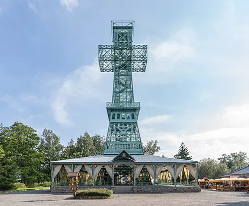
Großer Auerberg PantheraLeo1359531 · CC BY 4.0

Climate of Güntersberge
Best months for sightseeingBest months for sightseeing: June–August.
This month · November
A cold month
Day 6° · Night 0° · Rain 75 mm
- Hottest month
- August (day 21°)
- Coldest month
- January (night -4°)
- Wettest month
- December (82 mm)
- Driest month
- February (55 mm)
Bars: average monthly low and high temperature. Below: precipitation. Monthly averages for 1970–2000 at about 18 km resolution, adjusted for elevation. Highlighted months are mild and relatively dry. Source: WorldClim 2.1 (CC BY 4.0).
Show values as a table
| Month | Jan | Feb | Mar | Apr | May | Jun | Jul | Aug | Sep | Oct | Nov | Dec |
|---|---|---|---|---|---|---|---|---|---|---|---|---|
| Average high (°C) | 2° | 3° | 6° | 10° | 16° | 19° | 21° | 21° | 17° | 12° | 6° | 3° |
| Average low (°C) | -4° | -3° | -1° | 2° | 6° | 9° | 11° | 11° | 8° | 4° | 0° | -2° |
| Precipitation (mm) | 69 | 55 | 72 | 58 | 66 | 78 | 78 | 69 | 65 | 64 | 75 | 82 |
How to get to Güntersberge
The nearest airport is Erfurt-Weimar Airport (ERF), 74 km to the south as the crow flies. The nearest large city is Salzgitter, 69 km to the northwest.
Airports
- Erfurt-Weimar Airport (ERF) Erfurt 74 kmsouth
- Leipzig/Halle Airport (LEJ) Schkeuditz 90 kmeast
- Kassel Airport (KSF) Calden 113 kmwest
Nearby large cities
- Salzgitter Population: 105K 69 kmnorthwest
- Magdeburg Population: 244.3K 70 kmnortheast
- Halle Population: 237.9K 72 kmeast
- Göttingen Population: 122.1K 74 kmwest
- Erfurt Population: 218.8K 74 kmsouth
Straight-line distances; road distances are longer. Airport data: OurAirports.
Day trips from Güntersberge
Within 100 km: 535 historic and cultural sites, 3,633 natural sites, 752 lakes, rivers and coasts.
0–25 km413 places
- Bere River 19 kmSW
- Zillerbachtalsperre Lake 21 kmNW
- Talsperre Wendefurth Lake 12 kmNW
- Teufelsteich Lake 10 kmE
25–60 km1,657 places
- Schalk River 43 kmNW
- Sarre River 47 kmNE
- Ehle River 48 kmNE
- Aue River 46 kmN
60–100 km2,850 places
- Buchenwald concentration camp Historic site 72 kmS
- Roda River 95 kmSE
- Roda River 97 kmSE
- Frieda River 78 kmSW
Straight-line distances.
Nearby attractions & nature
Everything nearby-
Heimberg Mountain, Harzgerode1.1 km NE
-
Lunbach River, Germany0.5 km W
-
Langenberg Mountain, Harzgerode2 km NW
-
Katzsohlbach River, Germany1.1 km SW
-
Herzberg Mountain, Harzgerode2.8 km NE
-
Hirschbuchenkopf Mountain, Harzgerode3.6 km E
Other cities and towns in Harzgerode
-
 Neudorf Village, Harzgerode10 km SE
-
 Dankerode Village, Harzgerode13 km SE
-
Harzgerode Village, Harzgerode11 km E
-
Friedrichshöhe Village, Harzgerode3.5 km W
-
 Königerode Village, Harzgerode16 km E
-
 Schielo Village, Harzgerode17 km E
Sources & licences
Data last updated: · 2 independent sources