- Elevation
- 244 m
- above sea level
- Local time
- UTC+01:00
- Europe/Berlin · UTC+01:00
- Airports
- DRS Dresden Airport63 km
- PRG Václav Havel Airport Prague121 km
About Beim Galgen
Beim Galgen is a mountain. Location: Weißenberg, Landkreis Bautzen. Elevation: 244 m. The best months to visit are June–August. The nearest airport is Dresden Airport (63 km). Nearby sights include Strohmberg and Wohlaer Berg.
Photos of Beim Galgen
-
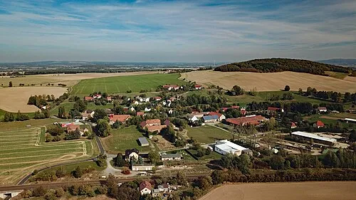
Wohlaer Berg PaulT · CC BY-SA 4.0

Climate of Beim Galgen
Best months for sightseeingBest months for sightseeing: June–August.
This month · November
A cold month
Day 6° · Night 2° · Rain 57 mm
- Hottest month
- August (day 23°)
- Coldest month
- January (night -3°)
- Wettest month
- August (89 mm)
- Driest month
- April (42 mm)
Bars: average monthly low and high temperature. Below: precipitation. Monthly averages for 1970–2000 at about 18 km resolution, adjusted for elevation. Highlighted months are mild and relatively dry. Source: WorldClim 2.1 (CC BY 4.0).
Show values as a table
| Month | Jan | Feb | Mar | Apr | May | Jun | Jul | Aug | Sep | Oct | Nov | Dec |
|---|---|---|---|---|---|---|---|---|---|---|---|---|
| Average high (°C) | 2° | 3° | 7° | 12° | 18° | 21° | 23° | 23° | 18° | 13° | 6° | 3° |
| Average low (°C) | -3° | -2° | 1° | 3° | 8° | 11° | 13° | 12° | 9° | 6° | 2° | -1° |
| Precipitation (mm) | 53 | 45 | 53 | 42 | 71 | 66 | 88 | 89 | 58 | 49 | 57 | 57 |
How to get to Beim Galgen
The nearest airport is Dresden Airport (DRS), 63 km to the west as the crow flies. The nearest large city is Dresden, 66 km to the west.
Airports
- Dresden Airport (DRS) Dresden 63 kmwest
- Václav Havel Airport Prague (PRG) Prague 121 kmsouth
- Zielona Góra-Babimost Airport (IEG) Nowe Kramsko 134 kmnortheast
Nearby large cities
- Dresden Population: 564.9K 66 kmwest
- Prague Population: 1.2M 121 kmsouth
- Chemnitz Population: 247.2K 127 kmwest
- Leipzig Population: 505K 161 kmwest
- Berlin Population: 3.4M 175 kmnorthwest
Straight-line distances; road distances are longer. Airport data: OurAirports.
Day trips from Beim Galgen
Within 100 km: 183 historic and cultural sites, 1,326 natural sites, 330 lakes, rivers and coasts.
0–25 km233 places
- Schlossteich Lake 23 kmN
- Speicherbecken Quitzdorf Lake 15 kmNE
- Litzenteich Lake 23 kmNW
- Großteich Lake 17 kmNE
25–60 km606 places
- Pirna-Sonnenstein Mountain 55 kmSW
- Vosí vrch Mountain 35 kmSW
- Buschteich Lake 32 kmNW
- Obersee Lake 34 kmNW
60–100 km1,000 places
- Erzgebirge Mountain 66 kmSW
- Lysá Mountain 70 kmS
- Tvarožník Mountain 73 kmSE
- Hořidla Mountain 74 kmS
Straight-line distances.
Nearest towns and villages
-
 Weißenberg Village, Weißenberg4 km N
-
Maltitz Village, Weißenberg2.7 km NE
-
 Lauske Village, Weißenberg3.5 km NW
-
Trauschwitz Village, Weißenberg0.8 km E
-
 Kittlitz Village, Löbau3.4 km S
-
 Zschorna Village, Hochkirch2.9 km W
Nearby attractions & nature
Everything nearby-
Strohmberg Mountain, Weißenberg1.8 km N
-
Wohlaer Berg Mountain, Löbau2.5 km SW
-
Slontschenberg Mountain, Weißenberg2.8 km NW
-
Schafberg Mountain, Löbau4 km S
-
Petschkenberg Mountain, Löbau4.1 km E
-
Schellenberg Mountain, Weißenberg5.3 km NW
-
Galgenberg Mountain, Weißenberg5.5 km NW
-
Alte Schanze Mountain, Löbau5.8 km S
Sources & licences
Data last updated: · 2 independent sources