Niederrengersdorf
Located in Kodersdorf, Landkreis Görlitz Coordinates: 51°13′32″ N 14°53′39″ E
- Elevation
- 187 m
- above sea level
- Local time
- UTC+01:00
- Europe/Berlin · UTC+01:00
- Airports
- DRS Dresden Airport79 km
- IEG Zielona Góra-Babimost Airport119 km
About Niederrengersdorf
Niederrengersdorf is a village. Location: Kodersdorf, Landkreis Görlitz. Elevation: 187 m. The best months to visit are June–August. The nearest airport is Dresden Airport (79 km). Nearby sights include Heideberg and Geiersberg.
Photos of Niederrengersdorf
-
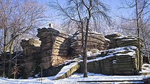
Hochstein Elfmeterschiessen · CC BY-SA 3.0

Climate of Niederrengersdorf
Best months for sightseeingBest months for sightseeing: June–August.
This month · November
A cold month
Day 6° · Night 2° · Rain 50 mm
- Hottest month
- August (day 23°)
- Coldest month
- January (night -3°)
- Wettest month
- July (77 mm)
- Driest month
- February (37 mm)
Bars: average monthly low and high temperature. Below: precipitation. Monthly averages for 1970–2000 at about 18 km resolution, adjusted for elevation. Highlighted months are mild and relatively dry. Source: WorldClim 2.1 (CC BY 4.0).
Show values as a table
| Month | Jan | Feb | Mar | Apr | May | Jun | Jul | Aug | Sep | Oct | Nov | Dec |
|---|---|---|---|---|---|---|---|---|---|---|---|---|
| Average high (°C) | 2° | 3° | 8° | 13° | 19° | 21° | 23° | 23° | 18° | 13° | 6° | 3° |
| Average low (°C) | -3° | -2° | 0° | 3° | 8° | 11° | 13° | 12° | 9° | 6° | 2° | -1° |
| Precipitation (mm) | 46 | 37 | 42 | 46 | 66 | 66 | 77 | 75 | 50 | 46 | 50 | 53 |
How to get to Niederrengersdorf
The nearest airport is Dresden Airport (DRS), 79 km to the west as the crow flies. The nearest large city is Dresden, 83 km to the west.
Airports
- Dresden Airport (DRS) Dresden 79 kmwest
- Zielona Góra-Babimost Airport (IEG) Nowe Kramsko 119 kmnortheast
- Václav Havel Airport Prague (PRG) Prague 133 kmsouth
Nearby large cities
- Dresden Population: 564.9K 83 kmwest
- Prague Population: 1.2M 131 kmsouth
- Chemnitz Population: 247.2K 144 kmwest
- Leipzig Population: 505K 176 kmwest
- Berlin Population: 3.4M 177 kmnorthwest
Straight-line distances; road distances are longer. Airport data: OurAirports.
Day trips from Niederrengersdorf
Within 100 km: 178 historic and cultural sites, 1,190 natural sites, 280 lakes, rivers and coasts.
0–25 km141 places
- Speicherbecken Quitzdorf Lake 11 kmNW
- Großteich Lake 13 kmNW
- Bannerteich Lake 11 kmNW
- Malena Lake 24 kmSW
25–60 km496 places
- Vosí vrch Mountain 51 kmSW
- Jastrzębiec Mountain 58 kmSE
- Buschteich Lake 38 kmNW
- Obersee Lake 39 kmNW
60–100 km1,011 places
- Erzgebirge Mountain 84 kmSW
- Pirna-Sonnenstein Mountain 73 kmSW
- Lysá Mountain 76 kmS
- Tvarožník Mountain 66 kmSE
Straight-line distances.
Nearby attractions & nature
Everything nearby-
Heideberg Mountain, Kodersdorf1.1 km W
-
Geiersberg Mountain, Kodersdorf1.7 km SE
-
Sandberg Mountain, Kodersdorf1.8 km NE
-
Rabenstein Mountain, Kodersdorf3.3 km W
-
Schoorstein Mountain, Kodersdorf3.4 km SW
-
Schoorstein Mountain, Kodersdorf3.4 km SW
Sources & licences
Data last updated: