Liebstadt
Located in Sächsische Schweiz-Osterzgebirge, Saxony Coordinates: 50°51′48″ N 13°50′34″ E
- Population
- 1,207
- 1.2K
- Elevation
- 442 m
- above sea level
- Local time
- UTC+01:00
- Europe/Berlin · UTC+01:00
- Places inside
- 16
- listed under Liebstadt
- Airports
- DRS Dresden Airport31 km
- PRG Václav Havel Airport Prague90 km
About Liebstadt
Liebstadt is a village. Location: Sächsische Schweiz-Osterzgebirge, Saxony. Population: 1,207. Elevation: 442 m.
Liebstadt (German pronunciation: [ˈliːpˌʃtat] ) is a town in the Sächsische Schweiz-Osterzgebirge district, in the Free State of Saxony, Germany. It is situated 12 km (7.5 mi) southwest of Pirna, and 23 km (14 mi) southeast of Dresden (centre).
Source: Wikipedia · CC BY-SA 4.0
Photos of Liebstadt
-
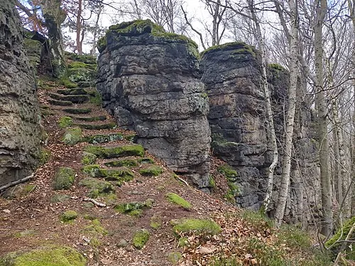
Hochstein Singlespeedfahrer · CC0 -

Finckenfang Norbert Kaiser · CC BY-SA 3.0


Places bordering Liebstadt
- Bahretal
- Altenberg
Population of Liebstadt over time
| 2017 | 1,294 | |
|---|---|---|
| 2019 | 1,291 | |
| 2021 | 1,271 | |
| 2022 | 1,268 | |
| 2023 | 1,248 | |
| 2024 | 1,207 | |
| 2025 | 1,190 |
Censuses and official estimates; source: Wikidata.
Climate of Liebstadt
Best months for sightseeingBest months for sightseeing: June–August.
This month · November
A cold month
Day 5° · Night 0° · Rain 54 mm
- Hottest month
- August (day 22°)
- Coldest month
- January (night -4°)
- Wettest month
- July (87 mm)
- Driest month
- February (41 mm)
Bars: average monthly low and high temperature. Below: precipitation. Monthly averages for 1970–2000 at about 18 km resolution, adjusted for elevation. Highlighted months are mild and relatively dry. Source: WorldClim 2.1 (CC BY 4.0).
Show values as a table
| Month | Jan | Feb | Mar | Apr | May | Jun | Jul | Aug | Sep | Oct | Nov | Dec |
|---|---|---|---|---|---|---|---|---|---|---|---|---|
| Average high (°C) | 1° | 2° | 7° | 12° | 17° | 20° | 22° | 22° | 17° | 12° | 5° | 2° |
| Average low (°C) | -4° | -4° | -1° | 2° | 7° | 10° | 12° | 12° | 9° | 5° | 0° | -2° |
| Precipitation (mm) | 45 | 41 | 51 | 41 | 64 | 77 | 87 | 82 | 56 | 49 | 54 | 53 |
How to get to Liebstadt
The nearest airport is Dresden Airport (DRS), 31 km to the north as the crow flies. The nearest large city is Dresden, 22 km to the north.
Airports
- Dresden Airport (DRS) Dresden 31 kmnorth
- Václav Havel Airport Prague (PRG) Prague 90 kmsouth
- Karlovy Vary Airport (KLV) Karlovy Vary 99 kmsouthwest
Nearby large cities
- Dresden Population: 564.9K 22 kmnorth
- Chemnitz Population: 247.2K 64 kmwest
- Prague Population: 1.2M 96 kmsoutheast
- Leipzig Population: 505K 116 kmnorthwest
- Gera Population: 104.7K 124 kmwest
Straight-line distances; road distances are longer. Airport data: OurAirports.
Day trips from Liebstadt
Within 100 km: 293 historic and cultural sites, 1,862 natural sites, 391 lakes, rivers and coasts.
0–25 km366 places
- Erzgebirge Mountain 4 kmNW
- Pirna-Sonnenstein Mountain 13 kmNE
- Taubenteich Lake 20 kmE
- Rückhaltebecken Reinhardtsgrimma Lake 8 kmW
25–60 km950 places
- Hořidla Mountain 47 kmSE
- Vosí vrch Mountain 39 kmE
- Weißiger Großteich Lake 56 kmN
- Vierteich Lake 45 kmN
60–100 km1,230 places
- Lysá Mountain 77 kmSE
- Stoličná Mountain 78 kmSW
- Svatý Prokop Landmark 82 kmSW
- Buschteich Lake 75 kmNE
Straight-line distances.
Places in Liebstadt
16 places
Liebstadt
Population: 1.4K


Cities & villages5
- Herbergen · Village
- Lichtenberg · Village
- Schlottwitz · Village
- Seitenhain · Village
- Waltersdorf · Village
Mountains & nature5
- Hirsch-Berg · Mountain
- Kleppelberg · Mountain
- Langenbrucken Berg · Mountain
- Lederberg · Mountain
- Platte · Mountain
Nearby attractions & nature
Everything nearby-
Börnersdorferbach River, Saxony1 km E
-
Trebnitzbach River, Saxony2.1 km W
-
Rückhaltebecken Liebstadt Lake, Saxony2.2 km SE
-
Roter Berg Mountain, Bahretal3.3 km E
-
Wittigschloß Historic site, Glashütte3.4 km SW
-
Grauhübel Mountain, Glashütte3.7 km NW
Sources & licences
Data last updated: · 2 independent sources