Altenkattbek
Located in Jevenstedt, Kreis Rendsburg-Eckernförde Coordinates: 54°13′45″ N 9°41′42″ E
- Elevation
- 11 m
- above sea level
- Local time
- UTC+01:00
- Europe/Berlin · UTC+01:00
- Airports
- HAM Hamburg Helmut Schmidt Airport69 km
- LBC Lübeck Blankensee Airport82 km
About Altenkattbek
Altenkattbek is a village. Location: Jevenstedt, Kreis Rendsburg-Eckernförde. Elevation: 11 m. The best months to visit are June–August. The nearest airport is Hamburg Helmut Schmidt Airport (69 km). Nearby sights include Bockhorstberg and Flöhenberg.
Photos of Altenkattbek
-
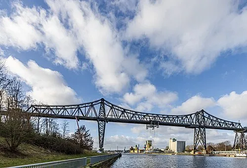
Rendsburg Transporter Bridge Matthias Süßen · CC BY-SA 4.0

Climate of Altenkattbek
Best months for sightseeingBest months for sightseeing: June–August.
This month · November
A cold month
Day 7° · Night 2° · Rain 80 mm
- Hottest month
- August (day 21°)
- Coldest month
- February (night -2°)
- Wettest month
- December (86 mm)
- Driest month
- February (48 mm)
Bars: average monthly low and high temperature. Below: precipitation. Monthly averages for 1970–2000 at about 18 km resolution, adjusted for elevation. Highlighted months are mild and relatively dry. Source: WorldClim 2.1 (CC BY 4.0).
Show values as a table
| Month | Jan | Feb | Mar | Apr | May | Jun | Jul | Aug | Sep | Oct | Nov | Dec |
|---|---|---|---|---|---|---|---|---|---|---|---|---|
| Average high (°C) | 3° | 4° | 7° | 11° | 17° | 20° | 21° | 21° | 17° | 12° | 7° | 4° |
| Average low (°C) | -1° | -2° | 1° | 3° | 7° | 10° | 12° | 12° | 9° | 6° | 2° | 0° |
| Precipitation (mm) | 77 | 48 | 66 | 48 | 52 | 78 | 81 | 74 | 82 | 83 | 80 | 86 |
How to get to Altenkattbek
The nearest airport is Hamburg Helmut Schmidt Airport (HAM), 69 km to the south as the crow flies. The nearest large city is Kiel, 30 km to the east.
Airports
- Hamburg Helmut Schmidt Airport (HAM) Hamburg 69 kmsouth
- Lübeck Blankensee Airport (LBC) Lübeck 82 kmsoutheast
- Sønderborg Airport (SGD) Sønderborg 82 kmnorth
Nearby large cities
- Kiel Population: 252.7K 30 kmeast
- Lübeck Population: 212.2K 76 kmsoutheast
- Bremerhaven Population: 118.6K 105 kmsouthwest
- Odense Population: 180.9K 137 kmnorth
- Bremen Population: 546.5K 141 kmsouthwest
Straight-line distances; road distances are longer. Airport data: OurAirports.
Day trips from Altenkattbek
Within 100 km: 299 historic and cultural sites, 1,798 natural sites, 1,141 lakes, rivers and coasts.
0–25 km326 places
- Spock River 25 kmE
- Aubek River 21 kmS
- Rader Insel Island 12 kmN
- Wittensee Lake 18 kmN
25–60 km1,203 places
- Oxbek River 45 kmN
- Noer Strand Beach 33 kmNE
- Hafen Strände Beach 39 kmNE
- Lehmbergstrand Beach 37 kmNE
60–100 km1,709 places
- Als Island 85 kmN
- Fehmarn Island 98 kmE
- Aeroe Island 84 kmNE
- Nordstrand Natural site 61 kmNW
Straight-line distances.
Nearby attractions & nature
Everything nearby-
Bockhorstberg Mountain, Jevenstedt0.8 km N
-
Flöhenberg Mountain, Jevenstedt0.4 km W
-
Kattbek River, Schleswig-Holstein0.4 km W
-
Schwaber Holz Natural site, Schleswig-Holstein1.6 km N
-
Jevenstedter St. Georg-Kirche Attraction, Jevenstedt2.1 km W
-
Brammer Au River, Schleswig-Holstein2.3 km E
Sources & licences
Data last updated: