Brodersby-Goltoft
Located in Kreis Schleswig-Flensburg, Schleswig-Holstein Coordinates: 54°32′28″ N 9°42′55″ E

- Population
- 669
- 669
- Elevation
- 17 m
- above sea level
- Local time
- UTC+01:00
- Europe/Berlin · UTC+01:00
- Places inside
- 11
- listed under Brodersby-Goltoft
- Airports
- SGD Sønderborg Airport47 km
- GWT Westerland Sylt Airport98 km
About Brodersby-Goltoft
Brodersby-Goltoft is a village. Location: Kreis Schleswig-Flensburg, Schleswig-Holstein. Population: 669. Elevation: 17 m.
Brodersby-Goltoft (German pronunciation: [ˈbʁoːdɐsbyː ˈɡɔltɔft]) is a municipality in the district of Schleswig-Flensburg, in Schleswig-Holstein, Germany. In March 2018, the former municipality of Goltoft was merged into Brodersby, and the municipality was renamed into Brodersby-Goltoft.
Source: Wikipedia · CC BY-SA 4.0
Photos of Brodersby-Goltoft
-
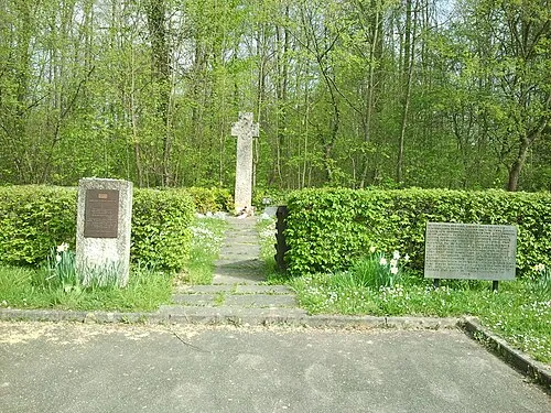
Kochendorf Concentration Camp RolfRoemmele · CC BY-SA 3.0

Population of Brodersby-Goltoft over time
| 2014 | 508 | |
|---|---|---|
| 2017 | 694 | |
| 2019 | 685 | |
| 2021 | 671 | |
| 2022 | 691 | |
| 2023 | 676 | |
| 2024 | 669 | |
| 2025 | 685 |
Censuses and official estimates; source: Wikidata.
Climate of Brodersby-Goltoft
Best months for sightseeingBest months for sightseeing: June–August.
This month · November
A cold month
Day 7° · Night 3° · Rain 75 mm
- Hottest month
- August (day 21°)
- Coldest month
- February (night -1°)
- Wettest month
- August (90 mm)
- Driest month
- April (48 mm)
Bars: average monthly low and high temperature. Below: precipitation. Monthly averages for 1970–2000 at about 18 km resolution, adjusted for elevation. Highlighted months are mild and relatively dry. Source: WorldClim 2.1 (CC BY 4.0).
Show values as a table
| Month | Jan | Feb | Mar | Apr | May | Jun | Jul | Aug | Sep | Oct | Nov | Dec |
|---|---|---|---|---|---|---|---|---|---|---|---|---|
| Average high (°C) | 3° | 3° | 6° | 10° | 15° | 18° | 20° | 21° | 17° | 12° | 7° | 4° |
| Average low (°C) | -1° | -1° | 1° | 3° | 7° | 10° | 12° | 12° | 10° | 6° | 3° | 0° |
| Precipitation (mm) | 76 | 55 | 76 | 48 | 54 | 72 | 88 | 90 | 82 | 84 | 75 | 78 |
How to get to Brodersby-Goltoft
The nearest airport is Sønderborg Airport (SGD), 47 km to the north as the crow flies. For international flights: Hamburg Helmut Schmidt Airport (HAM) (103 km). The nearest large city is Kiel, 37 km to the southeast.
Airports
- Sønderborg Airport (SGD) Sønderborg 47 kmnorth
- Westerland Sylt Airport (GWT) Sylt 98 kmnorthwest
- Hamburg Helmut Schmidt Airport (HAM) Hamburg 103 kmsouth
Nearby large cities
- Kiel Population: 252.7K 37 kmsoutheast
- Lübeck Population: 212.2K 98 kmsoutheast
- Odense Population: 180.9K 104 kmnortheast
- Bremerhaven Population: 118.6K 133 kmsouthwest
- Rostock Population: 198.3K 166 kmeast
Straight-line distances; road distances are longer. Airport data: OurAirports.
Day trips from Brodersby-Goltoft
Within 100 km: 189 historic and cultural sites, 1,225 natural sites, 909 lakes, rivers and coasts.
0–25 km291 places
- Oxbek River 10 kmN
- Noer Strand Beach 20 kmSE
- Lehmbergstrand Beach 18 kmE
- Kieholm Island 2 kmE
25–60 km771 places
- Als Island 51 kmN
- Aeroe Island 55 kmNE
- Nordstrand Natural site 54 kmW
- Spock River 46 kmSE
60–100 km1,261 places
- Fehmarn Island 93 kmE
- Tåsinge Island 76 kmNE
- Hundestrand Beach 88 kmSE
- Kniepsand Beach 90 kmW
Straight-line distances.
Places in Brodersby-Goltoft
11 placesBar: population relative to the most populous place in this list.
Cities & villages8
- Burg · Village
- Geel · Village
- Geelbyholz · Village
- Groß-Brodersby · Village
- Klein-Brodersby · Village
- Knöös · Village
- Norderfeld · Neighbourhood
- Schleihof · Village
Lakes, rivers & coasts1
- Geeler Bach · River
Nearby attractions & nature
Everything nearby-
Kieholm Island, Schleswig-Holstein1.7 km E
-
Kielfot Island, Kosel2.8 km SW
-
Broholm Natural site, Schaalby2.6 km NW
-
Koseler Au River, Kosel2.5 km SE
-
Hestofter Holz Natural site, Ulsnis2.9 km N
-
Ornumer Noor Lake, Schleswig-Holstein2.9 km SE
Sources & licences
Data last updated: · 2 independent sources