Kreisfreie Stadt Lübeck
Located in Schleswig-Holstein, Germany Coordinates: 53°51′59″ N 10°41′23″ E
- Population
- 216,889
- 216.9K
- Elevation
- 5 m
- above sea level
- Local time
- UTC+01:00
- Europe/Berlin · UTC+01:00
- Places inside
- 1
- listed under Kreisfreie Stadt Lübeck
- Airports
- LBC Lübeck Blankensee Airport7 km
- HAM Hamburg Helmut Schmidt Airport53 km
About Kreisfreie Stadt Lübeck
Kreisfreie Stadt Lübeck is a municipality. Location: Schleswig-Holstein, Germany. Population: 216,889. Elevation: 5 m. The best months to visit are June–August. The nearest airport is Lübeck Blankensee Airport (7 km). Nearby sights include Wallhalbinsel and Krähenteich.
Photos of Kreisfreie Stadt Lübeck
-
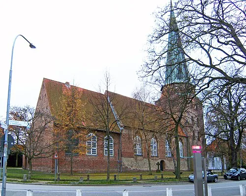
St. Lorenz Roland.h.bueb · CC BY 3.0 -
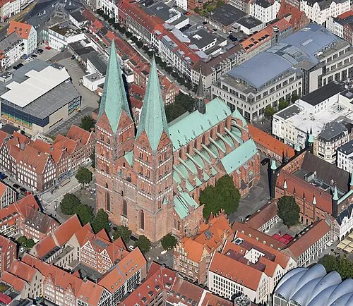
St. Mary's Church Carsten Steger · CC BY-SA 4.0


Climate of Kreisfreie Stadt Lübeck
Best months for sightseeingBest months for sightseeing: June–August.
This month · November
A cold month
Day 7° · Night 2° · Rain 61 mm
- Hottest month
- August (day 22°)
- Coldest month
- January (night -2°)
- Wettest month
- July (68 mm)
- Driest month
- February (37 mm)
Bars: average monthly low and high temperature. Below: precipitation. Monthly averages for 1970–2000 at about 18 km resolution, adjusted for elevation. Highlighted months are mild and relatively dry. Source: WorldClim 2.1 (CC BY 4.0).
Show values as a table
| Month | Jan | Feb | Mar | Apr | May | Jun | Jul | Aug | Sep | Oct | Nov | Dec |
|---|---|---|---|---|---|---|---|---|---|---|---|---|
| Average high (°C) | 3° | 4° | 7° | 12° | 17° | 20° | 22° | 22° | 18° | 13° | 7° | 5° |
| Average low (°C) | -2° | -2° | 1° | 3° | 7° | 11° | 12° | 12° | 9° | 6° | 2° | 0° |
| Precipitation (mm) | 57 | 37 | 52 | 44 | 46 | 65 | 68 | 62 | 59 | 57 | 61 | 66 |
How to get to Kreisfreie Stadt Lübeck
The nearest airport is Lübeck Blankensee Airport (LBC), 7 km to the south as the crow flies. For international flights: Hamburg Helmut Schmidt Airport (HAM) (53 km). The nearest large city is Lübeck, 1 km to the northwest.
Airports
- Lübeck Blankensee Airport (LBC) Lübeck 7 kmsouth
- Hamburg Helmut Schmidt Airport (HAM) Hamburg 53 kmsouthwest
- Rostock-Laage Airport (RLG) Laage 105 kmeast
Nearby large cities
- Lübeck Population: 212.2K 1 kmnorthwest
- Kiel Population: 252.7K 62 kmnorthwest
- Rostock Population: 198.3K 98 kmeast
- Bremerhaven Population: 118.6K 144 kmwest
- Bremen Population: 546.5K 153 kmsouthwest
Straight-line distances; road distances are longer. Airport data: OurAirports.
Day trips from Kreisfreie Stadt Lübeck
Within 100 km: 347 historic and cultural sites, 2,919 natural sites, 1,259 lakes, rivers and coasts.
0–25 km399 places
- Hundestrand Beach 20 kmN
- Strand Rosenhagen Beach 20 kmNE
- Hundestrand 1 Beach 23 kmNE
- Strand Kalkhorst Beach 24 kmNE
25–60 km1,721 places
- Poel Island Island 51 kmE
- Ziegelwerder Island 59 kmSE
- Viertbusch Natural site 46 kmSW
- Spock River 54 kmNW
60–100 km2,405 places
- Fehmarn Island 74 kmNE
- Aubek River 67 kmW
- Beke River 84 kmE
- Noer Strand Beach 81 kmNW
Straight-line distances.
Kreisfreie Stadt Lübeck and similar cities
Side by side with cities of similar size in the same country: population, elevation and climate.
| Measure | Kreisfreie Stadt Lübeck | Erfurt | Oberhausen | Lübeck |
|---|---|---|---|---|
| Population | 216.9K | 218.8K | 219.2K | 212.2K |
| Elevation | 5 m | 194 m | 44 m | 16 m |
| Summer day (hottest month) | 22° | 24° | 23° | 22° |
| Winter night (coldest month) | -2° | -2° | 1° | -2° |
| Annual rainfall | 674 mm | 584 mm | 883 mm | 674 mm |
| Best months | Jun–Aug | Jun–Sep | Jun–Aug | Jun–Aug |
| Distance | — | 322 km | 371 km | 0 km |
Climate values are 1970–2000 monthly averages; straight-line distance.
Places in Kreisfreie Stadt Lübeck
1 placeBar: population relative to the most populous place in this list.
Nearby attractions & nature
Everything nearby-
Wallhalbinsel Natural site, Schleswig-Holstein0.4 km W
-
Krähenteich Lake, Schleswig-Holstein0.5 km S
-
Mühlenteich Lake, Schleswig-Holstein0.8 km S
-
Wakenitz River, Schleswig-Holstein1.1 km E
-
Spieringshorst Island, Schleswig-Holstein3.3 km SE
-
Obere Trave River, Schleswig-Holstein3.2 km SW
-
Teerhofsinsel Island, Schleswig-Holstein4.4 km N
-
Landgraben River, Schleswig-Holstein3.8 km SE
Sources & licences
Data last updated: