- Population
- 815
- 815
- Elevation
- 14 m
- above sea level
- Local time
- UTC+02:00
- Europe/Athens · UTC+02:00
- Airports
- KVA Kavala Alexander the Great International Airport34 km
- AXD Alexandroupoli Democritus Airport117 km
About Potos
Potos is a village. Location: Thasos, Kavala. Population: 815. Elevation: 14 m.
Potos (Greek: Ποτός) is a village on the island of Thasos in northern Greece. The village is located in the south of the island, on the coast of the Thracian Sea (the northernmost part of the Aegean Sea) with a population of 788 residents (as of 2021). The seaside village is a popular tourist resort in the July-August Summer season, where tourism provides a large proportion of the income, alongside fishing and marble exploitation.
Source: Wikipedia · CC BY-SA 4.0
Photos of Potos
-
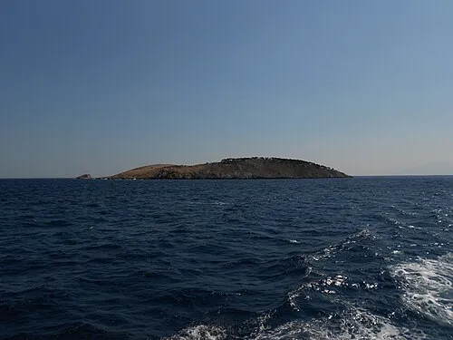
Panagia Island Cveleglg at Serbian Wikipedia · Public domain

Population of Potos over time
| 1991 | 554 | |
|---|---|---|
| 2001 | 645 | |
| 2011 | 815 | |
| 2021 | 788 |
Censuses and official estimates; source: Wikidata.
Climate of Potos
Best months for sightseeingBest months for sightseeing: May, September.
This month · November
Outside the best season
Day 15° · Night 8° · Rain 75 mm
- Hottest month
- July (day 31°)
- Coldest month
- January (night 3°)
- Wettest month
- December (78 mm)
- Driest month
- August (12 mm)
Bars: average monthly low and high temperature. Below: precipitation. Monthly averages for 1970–2000 at about 18 km resolution, adjusted for elevation. Highlighted months are mild and relatively dry. Source: WorldClim 2.1 (CC BY 4.0).
Show values as a table
| Month | Jan | Feb | Mar | Apr | May | Jun | Jul | Aug | Sep | Oct | Nov | Dec |
|---|---|---|---|---|---|---|---|---|---|---|---|---|
| Average high (°C) | 10° | 11° | 13° | 18° | 23° | 28° | 31° | 30° | 26° | 20° | 15° | 11° |
| Average low (°C) | 3° | 4° | 6° | 10° | 14° | 19° | 21° | 21° | 17° | 13° | 8° | 5° |
| Precipitation (mm) | 70 | 46 | 50 | 35 | 35 | 36 | 23 | 12 | 24 | 57 | 75 | 78 |
How to get to Potos
The nearest airport is Kavala Alexander the Great International Airport (KVA), 34 km to the north as the crow flies. The nearest large city is Çanakkale, 161 km to the east.
Airports
- Kavala Alexander the Great International Airport (KVA) Kavala 34 kmnorth
- Alexandroupoli Democritus Airport (AXD) Alexandroupolis 117 kmeast
- Thessaloniki Macedonia International Airport (SKG) Thessaloniki 139 kmwest
Nearby large cities
- Çanakkale Population: 143.6K 161 kmeast
- Plovdiv Population: 329.5K 172 kmnorth
- Edirne Population: 180K 202 kmnortheast
- Stara Zagora Population: 121.6K 220 kmnortheast
- Tekirdağ Population: 122.3K 248 kmeast
Straight-line distances; road distances are longer. Airport data: OurAirports.
Day trips from Potos
Within 100 km: 11 historic and cultural sites, 2 natural sites, 7 lakes, rivers and coasts.
0–25 km4 places
- Moní Agíou Panteleímonos Attraction 11 kmN
- Panagia Island Island 6 kmS
- Diapori Island 15 kmE
- Pelagos Island 6 kmS
25–60 km5 places
- Monastery of Great Lavra Attraction 53 kmS
- Mount Athos Mountain 56 kmSW
- Moni Analhpseos Attraction 59 kmNW
- Kynigós Historic site 54 kmN
60–100 km11 places
- Amygdalochóri Historic site 82 kmW
- Spalathronísia Island 95 kmSW
- Ekklisia Zoodochos Pigi Attraction 72 kmNW
- Agios Georgios Attraction 97 kmSE
Straight-line distances.
Nearby attractions & nature
Everything nearby-
Panagia Island Island, East Macedonia and Thrace5.8 km S
-
Pelagos Island, Kavala6.5 km S
-
Moní Agíou Panteleímonos Attraction, Thasos11 km N
-
Diapori Island, Thasos15 km E
Sources & licences
Data last updated: · 2 independent sources