Zakynthos
Located in Nomós Zakýnthou, Ionian Islands Coordinates: 37°47′00″ N 20°46′31″ E
- Population
- 38,883
- 38.9K
- Elevation
- 297 m
- above sea level
- Local time
- UTC+02:00
- Europe/Athens · UTC+02:00
- Places inside
- 84
- listed under Zakynthos
- Airports
- ZTH Zakynthos International Airport "Dionysios Solomos"10 km
- EFL Kefalonia International Airport "Anna Pollatou"45 km
About Zakynthos
Zakynthos is a municipality. Location: Nomós Zakýnthou, Ionian Islands. Population: 38,883. Elevation: 297 m. The best months to visit are May–July, September. The nearest airport is Zakynthos International Airport "Dionysios Solomos" (10 km).
Photos of Zakynthos
-
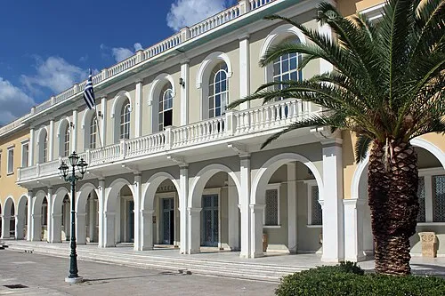
Byzantine Museum of Zakynthos Maesi64 · CC0

Climate of Zakynthos
Best months for sightseeingBest months for sightseeing: May–July, September.
This month · November
A wet month
Day 17° · Night 10° · Rain 157 mm
- Hottest month
- August (day 29°)
- Coldest month
- January (night 6°)
- Wettest month
- December (176 mm)
- Driest month
- July (7 mm)
Bars: average monthly low and high temperature. Below: precipitation. Monthly averages for 1970–2000 at about 18 km resolution, adjusted for elevation. Highlighted months are mild and relatively dry. Source: WorldClim 2.1 (CC BY 4.0).
Show values as a table
| Month | Jan | Feb | Mar | Apr | May | Jun | Jul | Aug | Sep | Oct | Nov | Dec |
|---|---|---|---|---|---|---|---|---|---|---|---|---|
| Average high (°C) | 12° | 12° | 14° | 17° | 22° | 26° | 29° | 29° | 26° | 21° | 17° | 14° |
| Average low (°C) | 6° | 6° | 7° | 9° | 13° | 16° | 19° | 19° | 17° | 14° | 10° | 7° |
| Precipitation (mm) | 143 | 110 | 90 | 56 | 24 | 10 | 7 | 11 | 39 | 126 | 157 | 176 |
Other places to visit in this season: May June July September
How to get to Zakynthos
The nearest airport is Zakynthos International Airport "Dionysios Solomos" (ZTH), 10 km to the east as the crow flies. The nearest large city is Piraeus, 253 km to the east.
Airports
- Zakynthos International Airport "Dionysios Solomos" (ZTH) Zakynthos 10 kmeast
- Kefalonia International Airport "Anna Pollatou" (EFL) Kefallinia Island 45 kmnorthwest
- Patras Araxos Agamemnon Airport (GPA) Patras 70 kmnortheast
Nearby large cities
- Piraeus Population: 163.7K 253 kmeast
- Athens Population: 664K 261 kmeast
Straight-line distances; road distances are longer. Airport data: OurAirports.
Day trips from Zakynthos
Within 100 km: 10 historic and cultural sites, 23 lakes, rivers and coasts.
0–25 km1 place
- Byzantine Museum of Zakynthos Museum 11 kmE
25–60 km10 places
- Kefalonia Island 54 kmN
- Moni Agiou Andrea Attraction 43 kmNW
- Monastery of Kipoureon Attraction 60 kmNW
- Monastery of the Virgin Mary of Atros Attraction 42 kmN
60–100 km22 places
- Nisídes Falarídes Island 67 kmNE
- Nisída Vasilikó Island 86 kmNE
- Skartsoubonisi Island 66 kmN
- Nisída Sáranta Island 85 kmNE
Straight-line distances.
Places in Zakynthos
84 places- 61 Kampi 59
- 62 Korithi 48
- 63 Loucha 46
- 64 Melinado 45
- 65 Mikro Nisi 38
- 66 Agia Thekli 36
- 67 Apelati 35
- 68 Giri 34
- 69 Chamouzas 33
- 70 Askos 31
- 71 Marathias 31
- 72 Varvara 30
- 73 Elies 26
- 74 Limontaiika 20
- 75 Koroni 10
- 76 Stimies 9
- 77 Agios Ioannis 8
- 78 Ai Giannis 8
- 79 Fterini 7
- 80 Kastelia 7
- 81 Psaraiika 7
- 82 Ampelos 2
- 83 Moni Strofadon 1
Bar: population relative to the most populous place in this list.
Heritage & sights1
- Byzantine Museum of Zakynthos · Museum
Sources & licences
Data last updated: