- Population
- 157
- 157
- Elevation
- 670 m
- above sea level
- Local time
- UTC+02:00
- Europe/Athens · UTC+02:00
- Airports
- KZI Kozani National Airport Filippos59 km
- OHD Ohrid St. Paul the Apostle Airport81 km
About Agios Vartholomaios
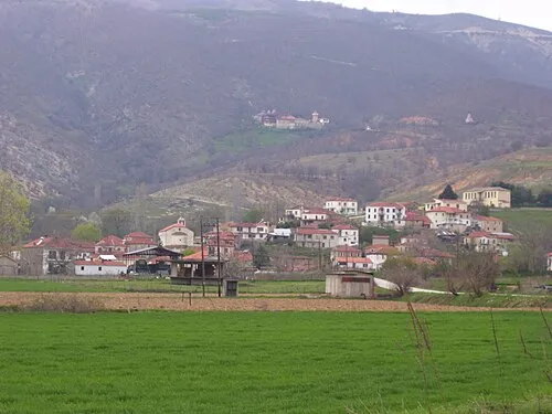
Agios Vartholomaios is a village. Location: Florina, Florina. Population: 157. Elevation: 670 m.
Agios Vartholomaios (Greek: Άγιος Βαρθολομαίος, before 1926: Βαρθολώμ – Vartholom, between 1926–1928: Βαρθολομαίος – Vartholomaios) is a village in Florina regional unit, Western Macedonia, Greece. The village has an altitude of 667 m (2,188 ft). In the late 15th century, the village was recorded as a timar holding with 26 families and as a settlement with a mixed population of Muslims and Christians. Later, as a Muslim populated village it belonged to the kaza (district) of Florina.
Source: Wikipedia · CC BY-SA 4.0
Population of Agios Vartholomaios over time
| 1991 | 333 | |
|---|---|---|
| 2001 | 422 | |
| 2011 | 172 | |
| 2021 | 137 |
Censuses and official estimates; source: Wikidata.
Climate of Agios Vartholomaios
Best months for sightseeingBest months for sightseeing: May–June, September.
This month · November
A cold month
Day 12° · Night 2° · Rain 79 mm
- Hottest month
- July (day 29°)
- Coldest month
- January (night -3°)
- Wettest month
- November (79 mm)
- Driest month
- July (37 mm)
Bars: average monthly low and high temperature. Below: precipitation. Monthly averages for 1970–2000 at about 18 km resolution, adjusted for elevation. Highlighted months are mild and relatively dry. Source: WorldClim 2.1 (CC BY 4.0).
Show values as a table
| Month | Jan | Feb | Mar | Apr | May | Jun | Jul | Aug | Sep | Oct | Nov | Dec |
|---|---|---|---|---|---|---|---|---|---|---|---|---|
| Average high (°C) | 5° | 8° | 12° | 17° | 22° | 27° | 29° | 29° | 25° | 19° | 12° | 7° |
| Average low (°C) | -3° | -1° | 2° | 5° | 9° | 13° | 15° | 15° | 11° | 7° | 2° | -1° |
| Precipitation (mm) | 54 | 47 | 52 | 52 | 56 | 45 | 37 | 40 | 43 | 75 | 79 | 59 |
How to get to Agios Vartholomaios
The nearest airport is Kozani National Airport Filippos (KZI), 59 km to the southeast as the crow flies. For international flights: Ohrid St. Paul the Apostle Airport (OHD) (81 km). The nearest large city is Sofia, 262 km to the northeast.
Airports
- Kozani National Airport Filippos (KZI) Kozani 59 kmsoutheast
- Ohrid St. Paul the Apostle Airport (OHD) Ohrid 81 kmnorthwest
- Thessaloniki Macedonia International Airport (SKG) Thessaloniki 125 kmeast
Nearby large cities
- Sofia Population: 1.2M 262 kmnortheast
- Niš Population: 250K 286 kmnorth
- Plovdiv Population: 329.5K 310 kmnortheast
- Athens Population: 664K 362 kmsoutheast
- Piraeus Population: 163.7K 362 kmsoutheast
Straight-line distances; road distances are longer. Airport data: OurAirports.
Day trips from Agios Vartholomaios
Within 100 km: 13 historic and cultural sites, 6 natural sites.
0–25 km2 places
- Moní Agíon Anargyron Attraction 23 kmSW
- Óros Vérno Mountain 16 kmSW
25–60 km8 places
- Korfoúla Historic site 51 kmSW
- Byzantine Museum of Kastoria Museum 35 kmSW
- Baltan Mountain 30 kmNW
- Moní Taksiarchón Tsoúkas Attraction 53 kmSW
60–100 km9 places
- Monastery of Agios Athanasios Sfinissis Attraction 84 kmE
- Aziz Aga bridge Landmark 88 kmS
- Vounása Mountain 92 kmS
- Pindus Mountains Mountain 91 kmSW
Straight-line distances.
Nearby attractions & nature
Everything nearby-
 Óros Vérno Mountain, Kastoria16 km SW
-
 Moní Agíon Anargyron Attraction, Kastoria23 km SW
Sources & licences
Data last updated: · 2 independent sources