Binn Ui Chuinneain (mullach thoir theas)
Located in County Galway, Connacht Coordinates: 53°32′43″ N 9°35′16″ W
- Elevation
- 479 m
- above sea level
- Local time
- UTC+00:00
- Europe/Dublin · UTC+00:00
- Airports
- NOC Ireland West Airport Knock65 km
- SNN Shannon Airport104 km
About Binn Ui Chuinneain (mullach thoir theas)
Binn Ui Chuinneain (mullach thoir theas) is a mountain. Location: County Galway, Connacht. Elevation: 479 m. The nearest airport is Ireland West Airport Knock (65 km). Nearby sights include Log na Brice (mullach thoir thuaidh) and Binn Ui Chuinneain (mullach theas).
Photos of Binn Ui Chuinneain (mullach thoir theas)
-

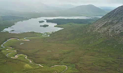
Devilsmother Keith Salvesen · CC BY-SA 2.0

Climate of Binn Ui Chuinneain (mullach thoir theas)
This month · November
A wet month
Day 8° · Night 2° · Rain 161 mm
- Hottest month
- August (day 16°)
- Coldest month
- January (night 1°)
- Wettest month
- November (161 mm)
- Driest month
- April (83 mm)
Bars: average monthly low and high temperature. Below: precipitation. Monthly averages for 1970–2000 at about 18 km resolution, adjusted for elevation. Highlighted months are mild and relatively dry. Source: WorldClim 2.1 (CC BY 4.0).
Show values as a table
| Month | Jan | Feb | Mar | Apr | May | Jun | Jul | Aug | Sep | Oct | Nov | Dec |
|---|---|---|---|---|---|---|---|---|---|---|---|---|
| Average high (°C) | 6° | 6° | 7° | 9° | 12° | 14° | 16° | 16° | 14° | 11° | 8° | 6° |
| Average low (°C) | 1° | 1° | 1° | 2° | 5° | 7° | 9° | 9° | 7° | 5° | 2° | 1° |
| Precipitation (mm) | 160 | 106 | 121 | 83 | 93 | 85 | 89 | 113 | 134 | 157 | 161 | 159 |
How to get to Binn Ui Chuinneain (mullach thoir theas)
The nearest airport is Ireland West Airport Knock (NOC), 65 km to the northeast as the crow flies. The nearest large city is Limerick, 117 km to the southeast.
Airports
- Ireland West Airport Knock (NOC) Charlestown 65 kmnortheast
- Shannon Airport (SNN) Shannon 104 kmsoutheast
- Kerry Airport (KIR) Farranfore 152 kmsouth
Nearby large cities
- Limerick Population: 102.3K 117 kmsoutheast
- Cork Population: 224K 198 kmsoutheast
- Dublin Population: 1M 223 kmeast
- Belfast Population: 348K 267 kmnortheast
Straight-line distances; road distances are longer. Airport data: OurAirports.
Day trips from Binn Ui Chuinneain (mullach thoir theas)
Within 100 km: 167 historic and cultural sites, 492 natural sites, 1,181 lakes, rivers and coasts.
0–25 km236 places
- Inchiquin Island 24 kmE
- Hare Island Island 12 kmSE
- Crow Island Island 21 kmS
- Illaunmore Island 21 kmS
25–60 km875 places
- Gorumna Island Island 32 kmS
- Inisheer Island 54 kmS
- Inishlyre Island 30 kmN
- Dooniver Strand Beach 56 kmNW
60–100 km729 places
- White Strand Beach 88 kmS
- Dunmoran Strand Beach 98 kmNE
- Pig Island Island 88 kmN
- Mutton Island Island 82 kmS
Straight-line distances.
Nearest towns and villages

Nearby attractions & nature
Everything nearby-
Log na Brice (mullach thoir thuaidh) Mountain, County Galway1.8 km SE
-
Binn Ui Chuinneain (mullach theas) Mountain, County Galway1.4 km NW
-
An Binn Bheag Mountain, County Galway1.6 km N
-
Binn Ui Chuinneain Mountain, County Galway1.8 km NW
-
Joyces River River, County Galway2.3 km SW
-
Knocknafaughy Mountain, County Galway3.5 km N
-
Knocknagur Mountain, County Galway3.8 km SW
-
Rinavore Mountain, County Galway3.9 km NW
More nature in Ireland
-
Devilsmother Mountain, County Galway7 km NW
-
Maam Valley Natural site, County Galway6.9 km S
-
Cnoc an Mhama Mountain, County Galway4.1 km SE
-
Benwee Mountain, County Galway4.2 km N
-
 Lissoughter Mountain, County Galway11 km SW
-
Taobh Dubh Mountain, County Galway5.2 km W
Sources & licences
Data last updated: