- Population
- 23
- 23
- Elevation
- 990 m
- above sea level
- Local time
- UTC+01:00
- Europe/Rome · UTC+01:00
- Airports
- PSR Abruzzo Airport60 km
- PEG Perugia San Francesco d'Assisi – Umbria International Airport96 km
About Comignano
Comignano is a village. Location: Cortino, Province of Teramo. Population: 23. Elevation: 990 m. The best months to visit are June–August. The nearest airport is Abruzzo Airport (60 km). Nearby sights include Chiesa di San Flaviano and Monte Pallone.
Photos of Comignano
-
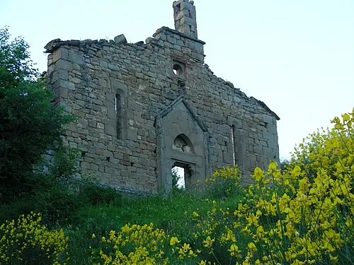
Chiesa di San Flaviano Original uploader was Luciodem at it.wikipedia · CC BY 3.0

Climate of Comignano
Best months for sightseeingBest months for sightseeing: June–August.
This month · November
A cold month
Day 9° · Night 2° · Rain 80 mm
- Hottest month
- July (day 24°)
- Coldest month
- February (night -2°)
- Wettest month
- October (96 mm)
- Driest month
- January (44 mm)
Bars: average monthly low and high temperature. Below: precipitation. Monthly averages for 1970–2000 at about 18 km resolution, adjusted for elevation. Highlighted months are mild and relatively dry. Source: WorldClim 2.1 (CC BY 4.0).
Show values as a table
| Month | Jan | Feb | Mar | Apr | May | Jun | Jul | Aug | Sep | Oct | Nov | Dec |
|---|---|---|---|---|---|---|---|---|---|---|---|---|
| Average high (°C) | 5° | 5° | 8° | 11° | 16° | 20° | 24° | 24° | 19° | 14° | 9° | 6° |
| Average low (°C) | -2° | -2° | 0° | 3° | 7° | 11° | 14° | 14° | 10° | 7° | 2° | -1° |
| Precipitation (mm) | 44 | 51 | 53 | 68 | 73 | 80 | 71 | 73 | 93 | 96 | 80 | 61 |
How to get to Comignano
The nearest airport is Abruzzo Airport (PSR), 60 km to the east as the crow flies. The nearest large city is Split, 258 km to the northeast.
Airports
- Abruzzo Airport (PSR) Pescara 60 kmeast
- Perugia San Francesco d'Assisi – Umbria International Airport (PEG) Perugia (PG) 96 kmnorthwest
- Marche Airport (AOI) Falconara Marittima (AN) 110 kmnorth
Nearby large cities
- Split Population: 149.8K 258 kmnortheast
- Rijeka Population: 108K 309 kmnorth
- Ljubljana Population: 272.2K 388 kmnorth
Straight-line distances; road distances are longer. Airport data: OurAirports.
Day trips from Comignano
Within 100 km: 153 historic and cultural sites, 264 natural sites, 34 lakes, rivers and coasts.
0–25 km44 places
- Monte Scalandro Mountain 15 kmNW
- Monte San Franco Mountain 22 kmSW
- Monte Portella Mountain 20 kmS
- Monte Piselli Mountain 18 kmN
25–60 km182 places
- Giulianova Beach Beach 40 kmNE
- Spiaggia Cupra Marittima Beach 53 kmNE
- Spiaggia Pedaso Beach 59 kmNE
- Spiaggia Roseto degli Abruzzi Beach 42 kmE
60–100 km225 places
- Appennino Umbro Mountain 96 kmNW
- Ripari di Giobbe Beach 78 kmE
- Valle Cerrese Natural site 75 kmSW
- Spiaggia Marina Palmense Beach 63 kmNE
Straight-line distances.
Nearby attractions & nature
Everything nearby-
Chiesa di San Flaviano Attraction, Rocca Santa Maria4.1 km NE
-
Monte Pallone Mountain, Abruzzo8.9 km W
-
Pizzo di Moscio Mountain, Umbria9.3 km W
-
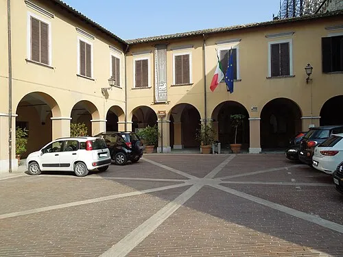 Museo Archeologico Nazionale Museum, Campli18 km NE
-
Monte Pelone Mountain, Valle Castellana11 km W
-
Valle Castellana Natural site, Abruzzo9.8 km NW
Sources & licences
Data last updated: · 2 independent sources