- Population
- 45
- 45
- Elevation
- 30 m
- above sea level
- Local time
- UTC+01:00
- Europe/Rome · UTC+01:00
- Airports
- BDS Brindisi Airport51 km
- BRI Bari Karol Wojtyła International Airport145 km
About Corsari
Corsari is a village. Location: Nardò, Province of Lecce. Population: 45. Elevation: 30 m. The best months to visit are May, October. The nearest airport is Brindisi Airport (51 km). Nearby sights include Frascone and Spiaggia Sant'Isidoro.
Climate of Corsari
Best months for sightseeingBest months for sightseeing: May, October.
This month · November
Outside the best season
Day 17° · Night 11° · Rain 75 mm
- Hottest month
- July (day 30°)
- Coldest month
- January (night 6°)
- Wettest month
- November (75 mm)
- Driest month
- July (13 mm)
Bars: average monthly low and high temperature. Below: precipitation. Monthly averages for 1970–2000 at about 18 km resolution, adjusted for elevation. Highlighted months are mild and relatively dry. Source: WorldClim 2.1 (CC BY 4.0).
Show values as a table
| Month | Jan | Feb | Mar | Apr | May | Jun | Jul | Aug | Sep | Oct | Nov | Dec |
|---|---|---|---|---|---|---|---|---|---|---|---|---|
| Average high (°C) | 13° | 13° | 15° | 18° | 23° | 27° | 30° | 30° | 26° | 22° | 17° | 14° |
| Average low (°C) | 6° | 6° | 8° | 10° | 14° | 18° | 21° | 21° | 18° | 14° | 11° | 7° |
| Precipitation (mm) | 60 | 51 | 52 | 31 | 22 | 15 | 13 | 24 | 42 | 74 | 75 | 63 |
How to get to Corsari
The nearest airport is Brindisi Airport (BDS), 51 km to the north as the crow flies. The nearest large city is Split, 388 km to the north.
Airports
- Brindisi Airport (BDS) Brindisi 51 kmnorth
- Bari Karol Wojtyła International Airport (BRI) Bari 145 kmnorthwest
- Crotone Sant'Anna Pythagoras Airport (CRV) Isola di Capo Rizzuto (KR) 154 kmsouthwest
Nearby large cities
- Split Population: 149.8K 388 kmnorth
Straight-line distances; road distances are longer. Airport data: OurAirports.
Day trips from Corsari
Within 100 km: 13 historic and cultural sites, 11 natural sites, 51 lakes, rivers and coasts.
0–25 km20 places
- Spiaggia Solemarebarocco Beach 10 kmNW
- Spiaggia Le Dune Beach 10 kmNW
- Spiaggia Scala di Furno Beach 11 kmNW
- Torre dell'Alto Lido Landmark 10 kmSE
25–60 km37 places
- Spiaggia di Porto Grande Beach 48 kmE
- Castello di Otranto Historic site 46 kmE
- Spiaggia Torre San Giovanni Beach 38 kmS
- Castello dei Trane Historic site 45 kmSE
60–100 km18 places
- Monte Specchio Mountain 78 kmNW
- Monte Orsetti Mountain 91 kmNW
- Monte Sant'Angelo Mountain 75 kmNW
- Capo San Vito Natural site 68 kmW
Straight-line distances.
Nearby attractions & nature
Everything nearby-
Frascone Beach, Nardò3.1 km W
-
Spiaggia Sant'Isidoro Beach, Nardò3.2 km NW
-
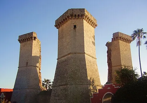 Le Quattro Colonne Landmark, Nardò9.2 km S
-
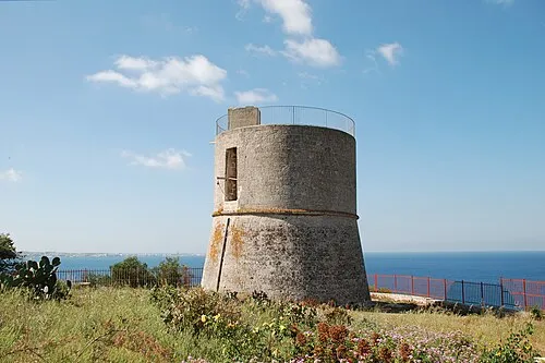 Torre dell'Alto Lido Landmark, Galatone10 km SE
-
Spiaggia Porto Cesareo Beach, Italy8.2 km NW
-
Spiaggia Le Dune Beach, Porto Cesareo10 km NW
Other cities and towns in Nardò
-
 Santa Maria al Bagno Village, Nardò8.7 km S
-
Villaggio Boncore Village, Nardò13 km NW
-
 Santa Caterina Village, Nardò7 km S
-
Santa Chiara Village, Nardò13 km NW
Sources & licences
Data last updated: · 2 independent sources