
- Population
- 407
- 407
- Elevation
- 123 m
- above sea level
- Local time
- UTC+01:00
- Europe/Rome · UTC+01:00
- Airports
- BLQ Bologna Guglielmo Marconi Airport20 km
- FLR Florence Airport, Peretola62 km
About Casagrande
Casagrande is a village. Location: Marzabotto, Province of Bologna. Population: 407. Elevation: 123 m. The best months to visit are May–June, September. The nearest airport is Bologna Guglielmo Marconi Airport (20 km). Nearby sights include Valle del Setta and Mont'Ovolo.
Climate of Casagrande
Best months for sightseeingBest months for sightseeing: May–June, September.
This month · November
Outside the best season
Day 12° · Night 5° · Rain 97 mm
- Hottest month
- July (day 30°)
- Coldest month
- January (night 0°)
- Wettest month
- November (97 mm)
- Driest month
- July (49 mm)
Bars: average monthly low and high temperature. Below: precipitation. Monthly averages for 1970–2000 at about 18 km resolution, adjusted for elevation. Highlighted months are mild and relatively dry. Source: WorldClim 2.1 (CC BY 4.0).
Show values as a table
| Month | Jan | Feb | Mar | Apr | May | Jun | Jul | Aug | Sep | Oct | Nov | Dec |
|---|---|---|---|---|---|---|---|---|---|---|---|---|
| Average high (°C) | 7° | 9° | 14° | 17° | 23° | 27° | 30° | 30° | 25° | 19° | 12° | 8° |
| Average low (°C) | 0° | 1° | 4° | 8° | 12° | 16° | 18° | 18° | 15° | 10° | 5° | 1° |
| Precipitation (mm) | 51 | 50 | 70 | 78 | 66 | 64 | 49 | 63 | 79 | 86 | 97 | 69 |
How to get to Casagrande
The nearest airport is Bologna Guglielmo Marconi Airport (BLQ), 20 km to the north as the crow flies. The nearest large city is Rijeka, 277 km to the northeast.
Airports
- Bologna Guglielmo Marconi Airport (BLQ) Bologna 20 kmnorth
- Florence Airport, Peretola (FLR) Firenze (FI) 62 kmsouth
- Forlì-Luigi Ridolfi International Airport (FRL) Forlì (FC) 71 kmeast
Nearby large cities
- Rijeka Population: 108K 277 kmnortheast
- Ljubljana Population: 272.2K 319 kmnortheast
- Innsbruck Population: 132.5K 322 kmnorth
- Nice Population: 342.7K 325 kmwest
- Klagenfurt Population: 100.3K 348 kmnortheast
Straight-line distances; road distances are longer. Airport data: OurAirports.
Day trips from Casagrande
Within 100 km: 66 historic and cultural sites, 204 natural sites, 15 lakes, rivers and coasts.
0–25 km4 places
- Monte Vigese Mountain 21 kmSW
- Mont'Ovolo Mountain 19 kmSW
- Valle del Setta Natural site 2 kmE
- Valle del Savena Natural site 22 kmNE
25–60 km85 places
- Poggio di Iavello Mountain 46 kmS
- Correggio Beach Beach 56 kmNW
- Monte Santa Giulia Mountain 44 kmW
- Monte Santa Croce Mountain 33 kmSE
60–100 km196 places
- Lido di Pomposa Beach 90 kmNE
- Vela Beach 87 kmE
- Big Mama Beach Beach 86 kmE
- Spiaggia Pinarella Beach 93 kmE
Straight-line distances.
Nearby attractions & nature
Everything nearby-
Valle del Setta Natural site, Emilia-Romagna1.5 km E
-
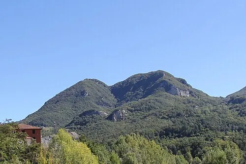 Mont'Ovolo Mountain, Grizzana Morandi19 km SW
-
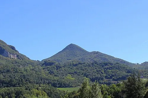 Monte Vigese Mountain, Camugnano21 km SW
-
Valle del Savena Natural site, Emilia-Romagna22 km NE
Other cities and towns in Marzabotto
-
 Pian di Venola Village, Marzabotto4.4 km SW
-
Cà di Cò Village, Marzabotto2.7 km S
-
Bottega Village, Marzabotto3.5 km NW
-
Allocco Village, Marzabotto5.6 km SE
-
 Sibano Village, Marzabotto5.7 km SW
-
Villa Aria Village, Marzabotto3.4 km S
Sources & licences
Data last updated: · 2 independent sources