Valsamoggia
Located in Province of Bologna, Emilia-Romagna Coordinates: 44°30′28″ N 11°05′54″ E
- Population
- 31,209
- 31.2K
- Elevation
- 78 m
- above sea level
- Local time
- UTC+01:00
- Europe/Rome · UTC+01:00
- Places inside
- 44
- listed under Valsamoggia
- Airports
- BLQ Bologna Guglielmo Marconi Airport15 km
- PMF Parma Airport73 km
About Valsamoggia
Valsamoggia is a municipality. Location: Province of Bologna, Emilia-Romagna. Population: 31,209. Elevation: 78 m. The best months to visit are May, September. The nearest airport is Bologna Guglielmo Marconi Airport (15 km). Nearby sights include Stadio Alberto Braglia and Teatro Storchi.
Climate of Valsamoggia
Best months for sightseeingBest months for sightseeing: May, September.
This month · November
A cold month
Day 11° · Night 4° · Rain 79 mm
- Hottest month
- July (day 31°)
- Coldest month
- January (night -1°)
- Wettest month
- October (82 mm)
- Driest month
- February (43 mm)
Bars: average monthly low and high temperature. Below: precipitation. Monthly averages for 1970–2000 at about 18 km resolution, adjusted for elevation. Highlighted months are mild and relatively dry. Source: WorldClim 2.1 (CC BY 4.0).
Show values as a table
| Month | Jan | Feb | Mar | Apr | May | Jun | Jul | Aug | Sep | Oct | Nov | Dec |
|---|---|---|---|---|---|---|---|---|---|---|---|---|
| Average high (°C) | 6° | 9° | 14° | 18° | 23° | 28° | 31° | 30° | 26° | 19° | 11° | 7° |
| Average low (°C) | -1° | 0° | 3° | 7° | 11° | 15° | 17° | 17° | 14° | 9° | 4° | 0° |
| Precipitation (mm) | 48 | 43 | 62 | 72 | 62 | 61 | 46 | 60 | 72 | 82 | 79 | 57 |
How to get to Valsamoggia
The nearest airport is Bologna Guglielmo Marconi Airport (BLQ), 15 km to the east as the crow flies. The nearest large city is Rijeka, 279 km to the east.
Airports
- Bologna Guglielmo Marconi Airport (BLQ) Bologna 15 kmeast
- Parma Airport (PMF) Parma (PR) 73 kmnorthwest
- Florence Airport, Peretola (FLR) Firenze (FI) 78 kmsouth
Nearby large cities
- Rijeka Population: 108K 279 kmeast
- Innsbruck Population: 132.5K 307 kmnorth
- Ljubljana Population: 272.2K 318 kmnortheast
- Nice Population: 342.7K 320 kmwest
- Klagenfurt Population: 100.3K 344 kmnortheast
Straight-line distances; road distances are longer. Airport data: OurAirports.
Day trips from Valsamoggia
Within 100 km: 57 historic and cultural sites, 159 natural sites, 9 lakes, rivers and coasts.
0–25 km4 places
- Valle del Setta Natural site 19 kmSE
- Teatro Storchi Attraction 20 kmNW
- Castello di Formigine Historic site 21 kmW
- Stadio Alberto Braglia Landmark 21 kmNW
25–60 km75 places
- Correggio Beach Beach 38 kmNW
- Monte Vigese Mountain 34 kmS
- Monte Santa Giulia Mountain 37 kmW
- Monte Santa Croce Mountain 50 kmSE
60–100 km146 places
- Lido di Pomposa Beach 94 kmE
- Poggio di Iavello Mountain 60 kmS
- Vela Beach 95 kmE
- Big Mama Beach Beach 95 kmE
Straight-line distances.
Places in Valsamoggia
44 places- 1 Bazzano 6.1K
- 2 Crespellano 4.4K
- 3 Calcara 2.4K
- 4 Castelletto 2.1K
- 5 Savigno 1.2K
- 6 Stiore 745
- 7 Bersagliera 432
- 8 Zappolino 406
- 9 Muffa 395
- 10 Ziribega 258
- 11 Fagnano 254
- 12 Bortolani 93
- 13 Cà Bianca 75
- 14 Vedegheto 73
- 15 Oliveto 71
- 16 Case Via Provinciale 68
- 17 Case Località Banzi 66
- 18 Goccia 64
- 19 Acquafredda 56
- 20 Margherita 56
- 21 Monteveglio 53
- 22 Zona Industriale Castelfranco 50
- 23 Mercatello 49
- 24 Castello di Serravalle 47
- 25 Priore 39
- 26 Villa 39
- 27 Area Produttiva Via Lunga 37
- 28 Montebudello 36
- 29 Tintoria 35
- 30 Cà Rossa 34
- 31 Cà Foscolo 31
- 32 Rio Cà Dè Fabbri 29
- 33 Riva Bene 28
- 34 Rodiano 23
- 35 Cà di Costa 21
- 36 Motta 21
- 37 Caseificio 19
- 38 Allegrina 18
- 39 Ponzano 16
- 40 San Prospero 14
- 41 Canonica 13
- 42 Tiola 13
- 43 Ruseghino 4
- 44 Sant'Apollinare 2
Bar: population relative to the most populous place in this list.
Nearby attractions & nature
Everything nearby-
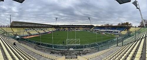 Stadio Alberto Braglia Landmark, Modena21 km NW
-
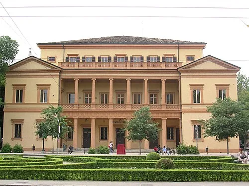 Teatro Storchi Attraction, Modena20 km NW
-
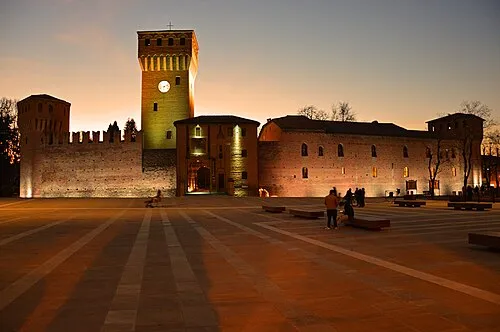 Castello di Formigine Historic site, Formigine21 km W
-
Valle del Setta Natural site, Emilia-Romagna19 km SE
Sources & licences
Data last updated: