Monchio delle Corti
Located in Province of Parma, Emilia-Romagna Coordinates: 44°24′47″ N 10°07′27″ E
- Population
- 880
- 880
- Elevation
- 817 m
- above sea level
- Local time
- UTC+01:00
- Europe/Rome · UTC+01:00
- Places inside
- 17
- listed under Monchio delle Corti
- Airports
- PMF Parma Airport48 km
- PSA Pisa International Airport84 km
About Monchio delle Corti
Monchio delle Corti is a municipality. Location: Province of Parma, Emilia-Romagna. Population: 880. Elevation: 817 m. The best months to visit are June–August. The nearest airport is Parma Airport (48 km). Nearby sights include Monte Caio and Monte Bocco.
Climate of Monchio delle Corti
Best months for sightseeingBest months for sightseeing: June–August.
This month · November
A wet month
Day 9° · Night 3° · Rain 185 mm
- Hottest month
- July (day 24°)
- Coldest month
- January (night -1°)
- Wettest month
- October (186 mm)
- Driest month
- July (57 mm)
Bars: average monthly low and high temperature. Below: precipitation. Monthly averages for 1970–2000 at about 18 km resolution, adjusted for elevation. Highlighted months are mild and relatively dry. Source: WorldClim 2.1 (CC BY 4.0).
Show values as a table
| Month | Jan | Feb | Mar | Apr | May | Jun | Jul | Aug | Sep | Oct | Nov | Dec |
|---|---|---|---|---|---|---|---|---|---|---|---|---|
| Average high (°C) | 6° | 7° | 9° | 12° | 17° | 21° | 24° | 24° | 20° | 14° | 9° | 7° |
| Average low (°C) | -1° | -1° | 1° | 4° | 8° | 11° | 14° | 14° | 11° | 7° | 3° | 0° |
| Precipitation (mm) | 134 | 101 | 121 | 137 | 104 | 98 | 57 | 91 | 133 | 186 | 185 | 141 |
How to get to Monchio delle Corti
The nearest airport is Parma Airport (PMF), 48 km to the north as the crow flies. For international flights: Pisa International Airport (PSA) (84 km). The nearest large city is Nice, 242 km to the west.
Airports
- Parma Airport (PMF) Parma (PR) 48 kmnorth
- Pisa International Airport (PSA) Pisa (PI) 84 kmsouth
- Bologna Guglielmo Marconi Airport (BLQ) Bologna 94 kmeast
Nearby large cities
- Nice Population: 342.7K 242 kmwest
- Innsbruck Population: 132.5K 332 kmnorth
- Bern Population: 121.6K 350 kmnorthwest
- Zurich Population: 415.4K 350 kmnorth
- Rijeka Population: 108K 356 kmeast
Straight-line distances; road distances are longer. Airport data: OurAirports.
Day trips from Monchio delle Corti
Within 100 km: 44 historic and cultural sites, 260 natural sites, 29 lakes, rivers and coasts.
0–25 km25 places
- Alpe di Succiso Mountain 11 kmSE
- Monte Casarola Mountain 11 kmSE
- Monte La Nuda Mountain 17 kmSE
- Monte Tondo Mountain 20 kmSE
25–60 km105 places
- Spiaggia della Marinella di San Terenzo Beach 41 kmSW
- La Spiaggia di Levanto Beach 49 kmSW
- Sun Beach Beach 59 kmW
- Spiaggia Forte dei Marmi Beach 51 kmS
60–100 km203 places
- Rotteri Mountain 60 kmW
- Poggio di Iavello Mountain 91 kmSE
- Gifarco Mountain 64 kmW
- Bagni Pagana Beach 72 kmW
Straight-line distances.
Places in Monchio delle Corti
17 places- 1 Monchio delle Corti 230
- 2 Pianadetto 145
- 3 Trefiumi 132
- 4 Valditacca 117
- 5 Casarola 78
- 6 Rimagna 67
- 7 Rigoso 58
- 8 Lugagnano Superiore 44
- 9 Vecciatica 44
- 10 Cozzanello 36
- 11 Ponte Lugagnano 35
- 12 Lugagnano Inferiore 34
- 13 Trincera 34
- 14 Ceda 33
- 15 Riana 26
- 16 Prato 24
- 17 Aneta 22
Bar: population relative to the most populous place in this list.
Nearby attractions & nature
Everything nearby-
Monte Caio Mountain, Tuscany6.5 km N
-
Monte Bocco Mountain, Licciana Nardi7.6 km S
-
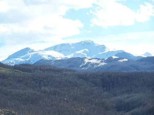 Alpe di Succiso Mountain, Ventasso11 km SE
-
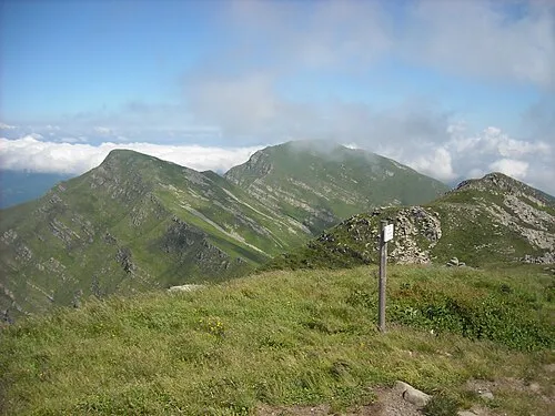 Monte Orsaro Mountain, Pontremoli11 km W
-
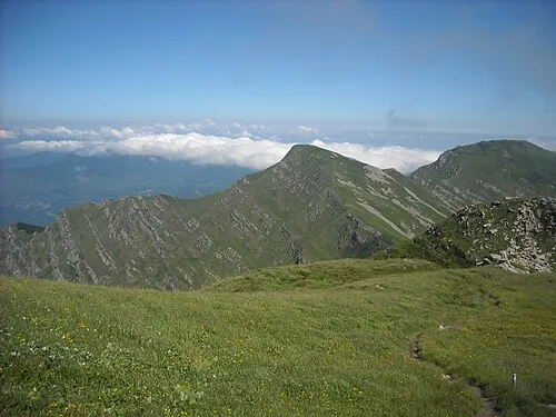 Monte Braiola Mountain, Emilia-Romagna11 km W
-
Punta Buefanaro Mountain, Comano10 km S
-
Monte Borgognone Mountain, Pontremoli11 km W
-
Monte Casarola Mountain, Ventasso11 km SE
Sources & licences
Data last updated: