Carpaneto Piacentino
Located in Province of Piacenza, Emilia-Romagna Coordinates: 44°54′55″ N 9°47′21″ E
- Population
- 7,740
- 7.7K
- Elevation
- 113 m
- above sea level
- Local time
- UTC+01:00
- Europe/Rome · UTC+01:00
- Places inside
- 24
- listed under Carpaneto Piacentino
- Airports
- PMF Parma Airport41 km
- VBS Brescia Gabriele d'Annunzio Airport71 km
About Carpaneto Piacentino
Carpaneto Piacentino is a municipality. Location: Province of Piacenza, Emilia-Romagna. Population: 7,740. Elevation: 113 m. The best months to visit are May, September. The nearest airport is Parma Airport (41 km). Nearby sights include Basilica di Sant'Antonino and Pietra Perduca.
Climate of Carpaneto Piacentino
Best months for sightseeingBest months for sightseeing: May, September.
This month · November
A cold month
Day 10° · Night 4° · Rain 87 mm
- Hottest month
- July (day 30°)
- Coldest month
- January (night -2°)
- Wettest month
- October (115 mm)
- Driest month
- July (38 mm)
Bars: average monthly low and high temperature. Below: precipitation. Monthly averages for 1970–2000 at about 18 km resolution, adjusted for elevation. Highlighted months are mild and relatively dry. Source: WorldClim 2.1 (CC BY 4.0).
Show values as a table
| Month | Jan | Feb | Mar | Apr | May | Jun | Jul | Aug | Sep | Oct | Nov | Dec |
|---|---|---|---|---|---|---|---|---|---|---|---|---|
| Average high (°C) | 6° | 8° | 14° | 17° | 23° | 27° | 30° | 29° | 24° | 17° | 10° | 6° |
| Average low (°C) | -2° | 0° | 3° | 6° | 11° | 15° | 17° | 17° | 14° | 9° | 4° | 0° |
| Precipitation (mm) | 65 | 52 | 67 | 83 | 70 | 77 | 38 | 69 | 78 | 115 | 87 | 64 |
How to get to Carpaneto Piacentino
The nearest airport is Parma Airport (PMF), 41 km to the east as the crow flies. For international flights: Milano Linate Airport (LIN) (71 km). The nearest large city is Nice, 242 km to the southwest.
Airports
- Parma Airport (PMF) Parma (PR) 41 kmeast
- Brescia Gabriele d'Annunzio Airport (VBS) Montichiari (BS) 71 kmnortheast
- Milano Linate Airport (LIN) Segrate (MI) 71 kmnorthwest
Nearby large cities
- Nice Population: 342.7K 242 kmsouthwest
- Zurich Population: 415.4K 289 kmnorth
- Innsbruck Population: 132.5K 289 kmnortheast
- Bern Population: 121.6K 290 kmnorthwest
- Winterthur Population: 111.8K 299 kmnorth
Straight-line distances; road distances are longer. Airport data: OurAirports.
Day trips from Carpaneto Piacentino
Within 100 km: 60 historic and cultural sites, 215 natural sites, 22 lakes, rivers and coasts.
0–25 km5 places
- Monte Mezzano Mountain 18 kmS
- Monte Dinavolo Mountain 18 kmW
- Pietra Perduca Mountain 25 kmW
- Monte Canate Mountain 20 kmSE
25–60 km110 places
- Rotteri Mountain 47 kmSW
- Fiume Ticino River 51 kmNW
- Gifarco Mountain 55 kmSW
- Monte Penice Mountain 40 kmW
60–100 km182 places
- Monte Bronzone Mountain 90 kmN
- Bagni Pagana Beach 78 kmSW
- Spiaggia della Marinella di San Terenzo Beach 93 kmS
- La Spiaggia di Levanto Beach 84 kmS
Straight-line distances.
Places in Carpaneto Piacentino
24 placesCarpaneto Piacentino
Population: 4.8K
Chero
Population: 200

Zena
Population: 168

Ciriano
Population: 124

Rezzano
Population: 101
Negrano
Population: 99
- 7 Malcantone 69
- 8 Badagnano 58
- 9 Case Bruciate-Centi 55
- 10 Caminata 52
- 11 Cerreto Landi 47
- 12 Case del Riglio 35
- 13 Ca' Poggi 34
- 14 Lo Stallone 34
- 15 Zappellazzo Sopra 31
- 16 Galiverta 30
- 17 Case Vecchie 29
- 18 Cimafava 29
- 19 Mirandola 27
- 20 San Lazzaro 27
- 21 Valle di Segola 16
- 22 Zappellazzo Sotto 16
- 23 Turca 14
- 24 Ceradello 12
Bar: population relative to the most populous place in this list.
Nearby attractions & nature
Everything nearby-
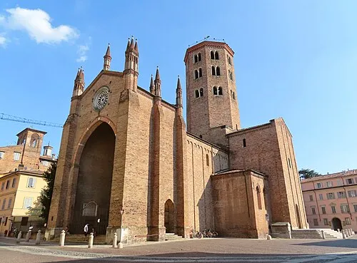 Basilica di Sant'Antonino Attraction, Piacenza17 km NW
-
Pietra Perduca Mountain, Travo25 km W
-
Monte Mezzano Mountain, Bore18 km S
-
Monte Dinavolo Mountain, Vigolzone18 km W
-
Monte Canate Mountain, Pellegrino Parmense20 km SE
Sources & licences
Data last updated: