- Population
- 1,145
- 1.1K
- Elevation
- 1,217 m
- above sea level
- Local time
- UTC+01:00
- Europe/Rome · UTC+01:00
- Airports
- TRS Trieste Airport102 km
- BZO Bolzano Airport105 km
About Granvilla
Granvilla is a village. Location: Sappada, Province of Udine. Population: 1,145. Elevation: 1,217 m. The best months to visit are July–August. The nearest airport is Trieste Airport (102 km). Nearby sights include Monte Siera and Monte Rinaldo.
Photos of Granvilla
-
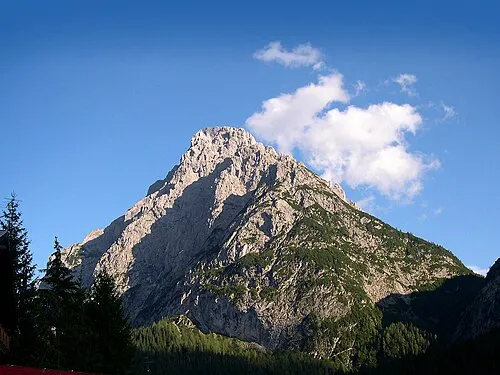
Monte Siera Lord Sidious from udine, italy · CC BY-SA 2.0

Climate of Granvilla
Best months for sightseeingBest months for sightseeing: July–August.
This month · November
A wet month
Day 6° · Night -1° · Rain 103 mm
- Hottest month
- July (day 20°)
- Coldest month
- January (night -5°)
- Wettest month
- July (154 mm)
- Driest month
- February (56 mm)
Bars: average monthly low and high temperature. Below: precipitation. Monthly averages for 1970–2000 at about 18 km resolution, adjusted for elevation. Highlighted months are mild and relatively dry. Source: WorldClim 2.1 (CC BY 4.0).
Show values as a table
| Month | Jan | Feb | Mar | Apr | May | Jun | Jul | Aug | Sep | Oct | Nov | Dec |
|---|---|---|---|---|---|---|---|---|---|---|---|---|
| Average high (°C) | 2° | 3° | 5° | 9° | 14° | 17° | 20° | 19° | 16° | 12° | 6° | 2° |
| Average low (°C) | -5° | -5° | -3° | 1° | 5° | 8° | 11° | 11° | 8° | 4° | -1° | -4° |
| Precipitation (mm) | 58 | 56 | 75 | 97 | 124 | 145 | 154 | 142 | 121 | 115 | 103 | 70 |
How to get to Granvilla
The nearest airport is Trieste Airport (TRS), 102 km to the southeast as the crow flies. The nearest large city is Klagenfurt, 124 km to the east.
Airports
- Trieste Airport (TRS) Ronchi dei Legionari/Trieste 102 kmsoutheast
- Bolzano Airport (BZO) Bolzano (BZ) 105 kmwest
- Treviso Airport (TSF) Treviso (TV) 109 kmsouth
Nearby large cities
- Klagenfurt Population: 100.3K 124 kmeast
- Innsbruck Population: 132.5K 125 kmnorthwest
- Salzburg Population: 157.2K 140 kmnorth
- Ljubljana Population: 272.2K 151 kmeast
- Rijeka Population: 108K 194 kmsoutheast
Straight-line distances; road distances are longer. Airport data: OurAirports.
Day trips from Granvilla
Within 100 km: 100 historic and cultural sites, 2,971 natural sites, 480 lakes, rivers and coasts.
0–25 km173 places
- Wolayersee Lake 15 kmE
- Vorderer Mooskofel Mountain 20 kmNE
- Demut Mountain 23 kmNW
- Monte Volaia Mountain 12 kmNE
25–60 km1,120 places
- Sille River 31 kmNW
- Vorderer Langtalsee Lake 49 kmN
- Schwarzsee Lake 59 kmN
- Brettersee Lake 58 kmN
60–100 km2,258 places
- Lake Bohinj Lake 95 kmE
- Triglav Mountain 91 kmE
- Rjavina Mountain 94 kmE
- Prestreljenik Mountain 64 kmE
Straight-line distances.
Nearby attractions & nature
Everything nearby-
Monte Siera Mountain, Province of Udine1.4 km SW
-
Monte Rinaldo Mountain, Santo Stefano di Cadore4.2 km NW
-
Monte Chiaine Mountain, Province of Udine4.3 km NE
-
Monte Carro Mountain, Santo Stefano di Cadore4.4 km NW
-
Monte Franza Mountain, Santo Stefano di Cadore4.8 km N
-
Monte Lastroni Mountain, Province of Udine5 km NE
Sources & licences
Data last updated: · 2 independent sources