- Population
- 888
- 888
- Elevation
- 71 m
- above sea level
- Local time
- UTC+01:00
- Europe/Rome · UTC+01:00
- Airports
- CIA Ciampino–G. B. Pastine International Airport30 km
- FCO Rome–Fiumicino Leonardo da Vinci International Airport43 km
About Spadellata
Spadellata is a village. Location: Anzio, Province of Rome. Population: 888. Elevation: 71 m. The best months to visit are May–June, October. The nearest airport is Ciampino–G. B. Pastine International Airport (30 km). Nearby sights include Spiaggia Lavinio and Forte Sangallo.
Climate of Spadellata
Best months for sightseeingBest months for sightseeing: May–June, October.
This month · November
A wet month
Day 17° · Night 8° · Rain 125 mm
- Hottest month
- August (day 30°)
- Coldest month
- January (night 4°)
- Wettest month
- November (125 mm)
- Driest month
- July (16 mm)
Bars: average monthly low and high temperature. Below: precipitation. Monthly averages for 1970–2000 at about 18 km resolution, adjusted for elevation. Highlighted months are mild and relatively dry. Source: WorldClim 2.1 (CC BY 4.0).
Show values as a table
| Month | Jan | Feb | Mar | Apr | May | Jun | Jul | Aug | Sep | Oct | Nov | Dec |
|---|---|---|---|---|---|---|---|---|---|---|---|---|
| Average high (°C) | 13° | 13° | 15° | 18° | 22° | 26° | 29° | 30° | 26° | 22° | 17° | 13° |
| Average low (°C) | 4° | 5° | 6° | 9° | 12° | 16° | 19° | 19° | 16° | 13° | 8° | 6° |
| Precipitation (mm) | 91 | 83 | 74 | 69 | 43 | 27 | 16 | 35 | 77 | 108 | 125 | 107 |
How to get to Spadellata
The nearest airport is Ciampino–G. B. Pastine International Airport (CIA), 30 km to the north as the crow flies. The nearest large city is Split, 384 km to the northeast.
Airports
- Ciampino–G. B. Pastine International Airport (CIA) Rome 30 kmnorth
- Rome–Fiumicino Leonardo da Vinci International Airport (FCO) Rome 43 kmnorthwest
- Naples International Airport (NAP) Napoli 158 kmsoutheast
Nearby large cities
- Split Population: 149.8K 384 kmnortheast
Straight-line distances; road distances are longer. Airport data: OurAirports.
Day trips from Spadellata
Within 100 km: 96 historic and cultural sites, 129 natural sites, 45 lakes, rivers and coasts.
0–25 km18 places
- Lido di Latino Beach 25 kmSE
- Spiaggia di Rio Torto Beach 14 kmNW
- Spiaggia Torvaianica Beach 18 kmNW
- Spiaggia Marina di Ardea Beach 7 kmNW
25–60 km117 places
- Sombrero Beach 60 kmSE
- La Bussola Beach 52 kmSE
- Spiaggia Saporetti Beach 47 kmSE
- Spiaggia Lilanda Beach 44 kmSE
60–100 km135 places
- Valle Cerrese Natural site 92 kmN
- Spiaggia delle Bambole Beach 79 kmSE
- Spiaggia Dell'Agave Beach 85 kmSE
- Ultima spiaggia Beach 85 kmSE
Straight-line distances.
Nearby attractions & nature
Everything nearby-
Spiaggia Lavinio Beach, Italy3.8 km SW
-
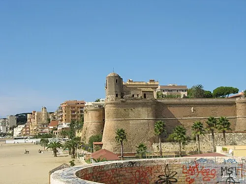 Forte Sangallo Historic site, Nettuno8.4 km SE
-
Lido di Sirene Beach, Italy6.5 km S
-
Spiaggia di Lavinio Beach, Anzio8.5 km S
-
Spiaggia Marina di Ardea Beach, Ardea7.3 km NW
-
Spiaggia di Anzio Beach, Italy8.3 km S
Sources & licences
Data last updated: · 2 independent sources