- Population
- 64
- 64
- Elevation
- 393 m
- above sea level
- Local time
- UTC+01:00
- Europe/Rome · UTC+01:00
- Airports
- FCO Rome–Fiumicino Leonardo da Vinci International Airport67 km
- CIA Ciampino–G. B. Pastine International Airport78 km
About Buon Respiro
Buon Respiro is a village. Location: Viterbo, Province of Viterbo. Population: 64. Elevation: 393 m. The best months to visit are May–June, September. The nearest airport is Rome–Fiumicino Leonardo da Vinci International Airport (67 km). Nearby sights include Palazzo dei Papi di Viterbo and Monte la Pallanzana.
Photos of Buon Respiro
-
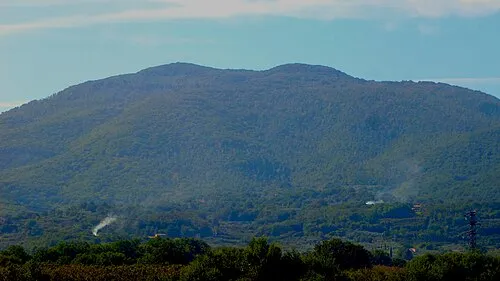
Monte Cimino Dino Michelini · CC BY 3.0 -

Villa Lante Orlando Paride · CC BY-SA 4.0 -
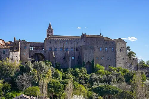
Palazzo dei Papi di Viterbo NikonZ7II · CC BY-SA 4.0


Climate of Buon Respiro
Best months for sightseeingBest months for sightseeing: May–June, September.
This month · November
Outside the best season
Day 13° · Night 6° · Rain 39 mm
- Hottest month
- July (day 29°)
- Coldest month
- January (night 2°)
- Wettest month
- November (39 mm)
- Driest month
- July (10 mm)
Bars: average monthly low and high temperature. Below: precipitation. Monthly averages for 1970–2000 at about 18 km resolution, adjusted for elevation. Highlighted months are mild and relatively dry. Source: WorldClim 2.1 (CC BY 4.0).
Show values as a table
| Month | Jan | Feb | Mar | Apr | May | Jun | Jul | Aug | Sep | Oct | Nov | Dec |
|---|---|---|---|---|---|---|---|---|---|---|---|---|
| Average high (°C) | 9° | 10° | 13° | 16° | 21° | 25° | 29° | 29° | 24° | 19° | 13° | 9° |
| Average low (°C) | 2° | 2° | 4° | 6° | 10° | 14° | 17° | 17° | 14° | 10° | 6° | 3° |
| Precipitation (mm) | 27 | 26 | 23 | 27 | 25 | 17 | 10 | 18 | 29 | 38 | 39 | 30 |
How to get to Buon Respiro
The nearest airport is Rome–Fiumicino Leonardo da Vinci International Airport (FCO), 67 km to the south as the crow flies. The nearest large city is Split, 374 km to the east.
Airports
- Rome–Fiumicino Leonardo da Vinci International Airport (FCO) Rome 67 kmsouth
- Ciampino–G. B. Pastine International Airport (CIA) Rome 78 kmsoutheast
- Perugia San Francesco d'Assisi – Umbria International Airport (PEG) Perugia (PG) 84 kmnortheast
Nearby large cities
- Split Population: 149.8K 374 kmeast
- Rijeka Population: 108K 375 kmnortheast
Straight-line distances; road distances are longer. Airport data: OurAirports.
Day trips from Buon Respiro
Within 100 km: 168 historic and cultural sites, 181 natural sites, 30 lakes, rivers and coasts.
0–25 km8 places
- Monte la Pallanzana Mountain 3 kmE
- Monte Festo Mountain 13 kmSE
- Monte Cimino Mountain 7 kmE
- Valle Petrana Natural site 22 kmSE
25–60 km71 places
- Valle Cerrese Natural site 47 kmE
- Boca Do Mar Beach 40 kmSW
- Ultima Spiaggia Beach 55 kmW
- Siaggia delle graticciare Beach 54 kmW
60–100 km300 places
- Appennino Umbro Mountain 93 kmNE
- Poggio Mosconcino Mountain 92 kmNW
- Parco della Rimembranza Natural site 91 kmNW
- Parco di Villa Pizzetti Natural site 92 kmNW
Straight-line distances.
Nearby attractions & nature
Everything nearby-
Palazzo dei Papi di Viterbo Historic site, Viterbo1.9 km NW
-
Monte la Pallanzana Mountain, Viterbo3 km E
-
Villa Lante Attraction, Viterbo4.3 km NE
-
Monte Cimino Mountain, Soriano nel Cimino7.2 km E
-
Valle Ospedale Natural site, Lazio5.2 km W
-
Monte Festo Mountain, Carbognano13 km SE
Other cities and towns in Viterbo
-
Tobia Village, Viterbo4.7 km S
-
Centro Giovanni XXIII Village, Viterbo4.7 km N
-
Casa Circondariale Mammagialla Village, Viterbo5.9 km N
-
Montefalco Village, Viterbo3.9 km S
-
 Castel d'Asso Village, Viterbo4.9 km W
-
Strada Romana Village, Viterbo4.6 km E
Sources & licences
Data last updated: · 2 independent sources