Torre de' Picenardi
Located in Province of Cremona, Lombardy Coordinates: 45°08′37″ N 10°17′13″ E
- Population
- 2,081
- 2.1K
- Elevation
- 38 m
- above sea level
- Local time
- UTC+01:00
- Europe/Rome · UTC+01:00
- Places inside
- 14
- listed under Torre de' Picenardi
- Airports
- VBS Brescia Gabriele d'Annunzio Airport32 km
- PMF Parma Airport35 km
About Torre de' Picenardi
Torre de' Picenardi is a municipality. Location: Province of Cremona, Lombardy. Population: 2,081. Elevation: 38 m. The best months to visit are May–June, September. The nearest airport is Brescia Gabriele d'Annunzio Airport (32 km). Nearby sights include Stadio Giovanni Zini and Valle del Po.
Climate of Torre de' Picenardi
Best months for sightseeingBest months for sightseeing: May–June, September.
This month · November
A cold month
Day 10° · Night 3° · Rain 74 mm
- Hottest month
- July (day 29°)
- Coldest month
- January (night -2°)
- Wettest month
- October (95 mm)
- Driest month
- February (41 mm)
Bars: average monthly low and high temperature. Below: precipitation. Monthly averages for 1970–2000 at about 18 km resolution, adjusted for elevation. Highlighted months are mild and relatively dry. Source: WorldClim 2.1 (CC BY 4.0).
Show values as a table
| Month | Jan | Feb | Mar | Apr | May | Jun | Jul | Aug | Sep | Oct | Nov | Dec |
|---|---|---|---|---|---|---|---|---|---|---|---|---|
| Average high (°C) | 5° | 8° | 14° | 18° | 23° | 26° | 29° | 29° | 25° | 18° | 10° | 6° |
| Average low (°C) | -2° | -1° | 3° | 7° | 11° | 15° | 18° | 17° | 13° | 9° | 3° | -1° |
| Precipitation (mm) | 59 | 41 | 55 | 62 | 65 | 61 | 46 | 70 | 70 | 95 | 74 | 56 |
How to get to Torre de' Picenardi
The nearest airport is Brescia Gabriele d'Annunzio Airport (VBS), 32 km to the north as the crow flies. For international flights: Verona Villafranca Valerio Catullo Airport (VRN) (55 km). The nearest large city is Innsbruck, 251 km to the north.
Airports
- Brescia Gabriele d'Annunzio Airport (VBS) Montichiari (BS) 32 kmnorth
- Parma Airport (PMF) Parma (PR) 35 kmsouth
- Verona Villafranca Valerio Catullo Airport (VRN) Caselle (VR) 55 kmnortheast
Nearby large cities
- Innsbruck Population: 132.5K 251 kmnorth
- Zurich Population: 415.4K 281 kmnorthwest
- Nice Population: 342.7K 289 kmsouthwest
- Winterthur Population: 111.8K 289 kmnorthwest
- Bern Population: 121.6K 298 kmnorthwest
Straight-line distances; road distances are longer. Airport data: OurAirports.
Day trips from Torre de' Picenardi
Within 100 km: 62 historic and cultural sites, 329 natural sites, 2 lakes, rivers and coasts.
0–25 km2 places
- Valle del Po Natural site 23 kmSE
- Stadio Giovanni Zini Landmark 20 kmW
25–60 km32 places
- Correggio Beach Beach 58 kmSE
- Monte Maddalena Mountain 45 kmN
- Monte Rocchetta Mountain 27 kmNE
- Monte Nuvolo Mountain 36 kmNE
60–100 km359 places
- Dosso Rotondo Mountain 90 kmNE
- Rotteri Mountain 93 kmSW
- Fiume Ticino River 83 kmW
- Monte Bronzone Mountain 67 kmN
Straight-line distances.
Places in Torre de' Picenardi
14 places- 1 Torre de' Picenardi 1K
- 2 San Lorenzo de' Picenardi 459
- 3 Ca' d'Andrea 216
- 4 Pozzo Baronzio 182
- 5 Casanova d'Offredi 93
- 6 Ca' Nove de' Biazzi 78
- 7 Ronca de' Golferani 62
- 8 Galizia 31
- 9 Fossa Guazzona 26
- 10 Brolpasino 22
- 11 Ca' de' Caggi 20
- 12 Canova 20
- 13 Breda Guazzona 17
- 14 Castelpersegano 17
Bar: population relative to the most populous place in this list.
Nearby attractions & nature
Everything nearby-
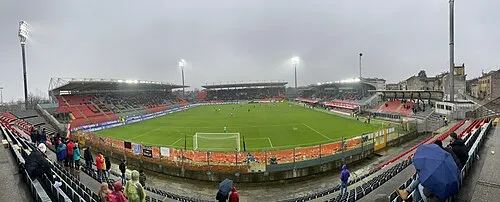 Stadio Giovanni Zini Landmark, Cremona20 km W
-
Valle del Po Natural site, Lombardy23 km SE
Sources & licences
Data last updated: