- Population
- 10,191
- 10.2K
- Elevation
- 31 m
- above sea level
- Local time
- UTC+01:00
- Europe/Rome · UTC+01:00
- Places inside
- 34
- listed under Goito
- Airports
- VRN Verona Villafranca Valerio Catullo Airport23 km
- VBS Brescia Gabriele d'Annunzio Airport33 km
About Goito
Goito is a municipality. Location: Province of Mantua, Lombardy. Population: 10,191. Elevation: 31 m. The best months to visit are May–June, September. The nearest airport is Verona Villafranca Valerio Catullo Airport (23 km). Nearby sights include Ducal palace and Monte Rosso.
Climate of Goito
Best months for sightseeingBest months for sightseeing: May–June, September.
This month · November
A cold month
Day 11° · Night 3° · Rain 59 mm
- Hottest month
- July (day 29°)
- Coldest month
- January (night -1°)
- Wettest month
- October (87 mm)
- Driest month
- February (37 mm)
Bars: average monthly low and high temperature. Below: precipitation. Monthly averages for 1970–2000 at about 18 km resolution, adjusted for elevation. Highlighted months are mild and relatively dry. Source: WorldClim 2.1 (CC BY 4.0).
Show values as a table
| Month | Jan | Feb | Mar | Apr | May | Jun | Jul | Aug | Sep | Oct | Nov | Dec |
|---|---|---|---|---|---|---|---|---|---|---|---|---|
| Average high (°C) | 6° | 9° | 14° | 17° | 23° | 27° | 29° | 29° | 25° | 18° | 11° | 6° |
| Average low (°C) | -1° | 0° | 3° | 7° | 12° | 16° | 18° | 18° | 14° | 9° | 3° | -1° |
| Precipitation (mm) | 51 | 37 | 47 | 55 | 67 | 67 | 53 | 69 | 64 | 87 | 59 | 51 |
How to get to Goito
The nearest airport is Verona Villafranca Valerio Catullo Airport (VRN), 23 km to the northeast as the crow flies. The nearest large city is Innsbruck, 230 km to the north.
Airports
- Verona Villafranca Valerio Catullo Airport (VRN) Caselle (VR) 23 kmnortheast
- Brescia Gabriele d'Annunzio Airport (VBS) Montichiari (BS) 33 kmnorthwest
- Parma Airport (PMF) Parma (PR) 56 kmsouthwest
Nearby large cities
- Innsbruck Population: 132.5K 230 kmnorth
- Zurich Population: 415.4K 286 kmnorthwest
- Winterthur Population: 111.8K 292 kmnorthwest
- Rijeka Population: 108K 296 kmeast
- Ljubljana Population: 272.2K 312 kmeast
Straight-line distances; road distances are longer. Airport data: OurAirports.
Day trips from Goito
Within 100 km: 59 historic and cultural sites, 438 natural sites, 1 lake, river or coast.
0–25 km4 places
- Monte Rocchetta Mountain 22 kmNW
- Monte Nuvolo Mountain 24 kmNW
- Monte Rosso Mountain 19 kmNW
- Ducal palace Historic site 14 kmSE
25–60 km86 places
- Correggio Beach Beach 56 kmS
- Monte Maddalena Mountain 45 kmNW
- Corno Barila Mountain 55 kmNE
- Monte Baldo Mountain 54 kmN
60–100 km408 places
- Spadalone Mountain 98 kmN
- Dosso Rotondo Mountain 64 kmN
- Monte Bronzone Mountain 73 kmNW
- Santa Corona Attraction 76 kmNE
Straight-line distances.
Places in Goito
34 places- 1 Goito 5.5K
- 2 Cerlongo 1.4K
- 3 Solarolo 418
- 4 Torre 292
- 5 Sacca 235
- 6 Calliera 212
- 7 Vasto 112
- 8 Massimbona 67
- 9 Ca' Vecchia Gobbi 65
- 10 Maglio 63
- 11 Segrada I 50
- 12 Borgo Diciotto 44
- 13 Ca' Vagliani 44
- 14 Cascina Palazzetto 40
- 15 Catapane 35
- 16 Aquilone 33
- 17 Terra Nera 33
- 18 Isola 32
- 19 Tezze Vasto 31
- 20 Ronziolo 30
- 21 Mussolina 26
- 22 Villabona 26
- 23 Loghino 25
- 24 Bellacqua 23
- 25 Corte Bassa 21
- 26 Corte Grande 21
- 27 Corte Quaresima Vecchia 20
- 28 Segrada II 20
- 29 Cascine Bondi 19
- 30 Valle Buratto 19
- 31 Corte Bellacqua di Sopra 18
- 32 Corte Merlesco 16
- 33 San Lorenzo 16
- 34 Corte Resenasco 11
Bar: population relative to the most populous place in this list.
Nearby attractions & nature
Everything nearby-
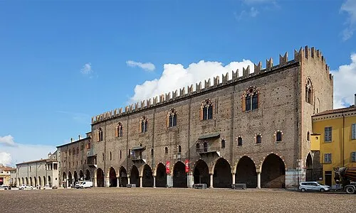 Ducal palace Historic site, Mantova14 km SE
-
Monte Rosso Mountain, Veneto19 km NW
-
Monte Rocchetta Mountain, Carpenedolo22 km NW
-
Monte Nuvolo Mountain, Veneto24 km NW
Sources & licences
Data last updated: