- Population
- 51
- 51
- Elevation
- 923 m
- above sea level
- Local time
- UTC+01:00
- Europe/Rome · UTC+01:00
- Airports
- BZO Bolzano Airport80 km
- BGY Il Caravaggio International Airport86 km
About Migiondo
Migiondo is a village. Location: Sondalo, Province of Sondrio. Population: 51. Elevation: 923 m. The best months to visit are June–August. The nearest airport is Bolzano Airport (80 km). Nearby sights include Monte Storile and Monte Fo.
Photos of Migiondo
-
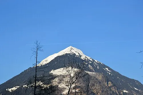
Monte Storile Gaggi Luca 76 · CC BY 3.0 -
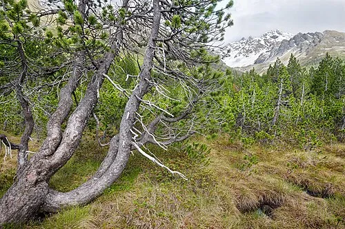
Cime Redasco Luca Carloni · CC BY-SA 4.0


Climate of Migiondo
Best months for sightseeingBest months for sightseeing: June–August.
This month · November
A cold month
Day 9° · Night 0° · Rain 38 mm
- Hottest month
- July (day 23°)
- Coldest month
- January (night -4°)
- Wettest month
- August (69 mm)
- Driest month
- February (22 mm)
Bars: average monthly low and high temperature. Below: precipitation. Monthly averages for 1970–2000 at about 18 km resolution, adjusted for elevation. Highlighted months are mild and relatively dry. Source: WorldClim 2.1 (CC BY 4.0).
Show values as a table
| Month | Jan | Feb | Mar | Apr | May | Jun | Jul | Aug | Sep | Oct | Nov | Dec |
|---|---|---|---|---|---|---|---|---|---|---|---|---|
| Average high (°C) | 5° | 6° | 9° | 12° | 17° | 20° | 23° | 23° | 19° | 14° | 9° | 5° |
| Average low (°C) | -4° | -4° | -1° | 2° | 7° | 10° | 12° | 12° | 9° | 5° | 0° | -3° |
| Precipitation (mm) | 29 | 22 | 28 | 37 | 59 | 66 | 65 | 69 | 62 | 58 | 38 | 28 |
How to get to Migiondo
The nearest airport is Bolzano Airport (BZO), 80 km to the east as the crow flies. For international flights: Il Caravaggio International Airport (BGY) (86 km). The nearest large city is Innsbruck, 133 km to the northeast.
Airports
- Bolzano Airport (BZO) Bolzano (BZ) 80 kmeast
- Il Caravaggio International Airport (BGY) Orio al Serio (BG) 86 kmsouthwest
- Brescia Gabriele d'Annunzio Airport (VBS) Montichiari (BS) 99 kmsouth
Nearby large cities
- Innsbruck Population: 132.5K 133 kmnortheast
- Zurich Population: 415.4K 177 kmnorthwest
- Winterthur Population: 111.8K 178 kmnorthwest
- Munich Population: 1.5M 223 kmnortheast
- Bern Population: 121.6K 230 kmwest
Straight-line distances; road distances are longer. Airport data: OurAirports.
Day trips from Migiondo
Within 100 km: 53 historic and cultural sites, 4,275 natural sites, 401 lakes, rivers and coasts.
0–25 km268 places
- Lago di Poschiavo Lake 17 kmW
- Lago Bianco Lake 24 kmNW
- Lej Minor Lake 24 kmNW
- Laghet d'Ur Lake 23 kmW
25–60 km1,607 places
- Spadalone Mountain 38 kmSE
- Chaviolas Island 44 kmW
- Lajets Lake 58 kmW
- Silvaplanersee Lake 42 kmW
60–100 km2,854 places
- Dosso Rotondo Mountain 79 kmSE
- Lake Davos Lake 65 kmNW
- Lag Prau Pulté Lake 97 kmNW
- Gotschnaseeli Lake 69 kmNW
Straight-line distances.
Nearby attractions & nature
Everything nearby-
Monte Storile Mountain, Grosio2.6 km W
-
Monte Fo Mountain, Sondalo3.2 km NW
-
La Pozza Mountain, Sondalo4 km N
-
Pizzo Alto alla Croce Mountain, Grosio3.8 km S
-
Mot del Ciò Mountain, Sondalo4.7 km SE
-
Dosso dell' Oca Mountain, Grosio4.6 km N
Other cities and towns in Sondalo
-
 Frontale Village, Sondalo5.5 km NE
-
Madonna della Biorca Village, Sondalo4.2 km NE
-
Le Prese-Pendosso Village, Sondalo5 km NE
-
Villaggio Sanatoriale E. Morelli Village, Sondalo2.1 km NE
-
Fumero Village, Sondalo6.4 km NE
Sources & licences
Data last updated: · 2 independent sources