- Population
- 221,238
- 221.2K
- Elevation
- 470 m
- above sea level
- Local time
- UTC+01:00
- Europe/Rome · UTC+01:00
- Places inside
- 84
- listed under Province of Campobasso
- Airports
- FOG Foggia Gino Lisa Airport71 km
- PSR Abruzzo Airport94 km
About Province of Campobasso
Province of Campobasso is a district. Location: Molise, Italy. Population: 221,238. The best months to visit are May–July, September. The nearest airport is Foggia Gino Lisa Airport (71 km). Nearby sights include Vallone Grande and Vallone Olivoli.
Photos of Province of Campobasso
-

Santa Maria Assunta Silvestro Buono · Public domain -
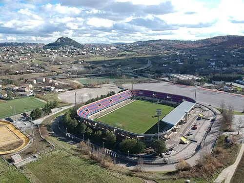
Stadio Nuovo Romagnoli MarcoMoffa · CC BY-SA 4.0


Climate of Province of Campobasso
Best months for sightseeingBest months for sightseeing: May–July, September.
This month · November
Outside the best season
Day 13° · Night 7° · Rain 64 mm
- Hottest month
- August (day 27°)
- Coldest month
- February (night 3°)
- Wettest month
- November (64 mm)
- Driest month
- July (28 mm)
Bars: average monthly low and high temperature. Below: precipitation. Monthly averages for 1970–2000 at about 18 km resolution, adjusted for elevation. Highlighted months are mild and relatively dry. Source: WorldClim 2.1 (CC BY 4.0).
Show values as a table
| Month | Jan | Feb | Mar | Apr | May | Jun | Jul | Aug | Sep | Oct | Nov | Dec |
|---|---|---|---|---|---|---|---|---|---|---|---|---|
| Average high (°C) | 9° | 9° | 12° | 15° | 20° | 24° | 27° | 27° | 23° | 18° | 13° | 10° |
| Average low (°C) | 3° | 3° | 4° | 7° | 12° | 15° | 18° | 18° | 15° | 11° | 7° | 4° |
| Precipitation (mm) | 45 | 43 | 40 | 42 | 36 | 31 | 28 | 37 | 47 | 53 | 64 | 53 |
Other places to visit in this season: May June July September
How to get to Province of Campobasso
The nearest airport is Foggia Gino Lisa Airport (FOG), 71 km to the southeast as the crow flies. For international flights: Abruzzo Airport (PSR) (94 km). The nearest large city is Split, 244 km to the northeast.
Airports
- Foggia Gino Lisa Airport (FOG) Foggia (FG) 71 kmsoutheast
- Abruzzo Airport (PSR) Pescara 94 kmnorthwest
- Naples International Airport (NAP) Napoli 99 kmsouthwest
Nearby large cities
- Split Population: 149.8K 244 kmnortheast
Straight-line distances; road distances are longer. Airport data: OurAirports.
Day trips from Province of Campobasso
Within 100 km: 87 historic and cultural sites, 131 natural sites, 32 lakes, rivers and coasts.
0–25 km24 places
- Vallone Grande Natural site 8 kmN
- Valle Covatta Natural site 14 kmSW
- Colle Tentale Mountain 21 kmW
- Sant'Angelo Altissimo Mountain 11 kmNW
25–60 km77 places
- Spiaggia Marina di Lesina Beach 54 kmNE
- Spiaggia Lido Cormoran Beach 54 kmNE
- Spiaggia Salvo Marina Beach 41 kmN
- Spiaggia Marina di Vasto Beach 44 kmN
60–100 km149 places
- Torre Mileto Beach 71 kmE
- Ripari di Giobbe Beach 80 kmN
- Cala Spido Beach 77 kmNE
- Lido del Gargano Beach 92 kmE
Straight-line distances.
Places in Province of Campobasso
84 places- 61 Cercepiccola 642
- 62 Acquaviva Collecroce 625
- 63 Campochiaro 625
- 64 San Felice del Molise 603
- 65 Morrone del Sannio 576
- 66 Castellino del Biferno 555
- 67 San Giovanni in Galdo 553
- 68 Macchia Valfortore 540
- 69 Casalciprano 517
- 70 Ripabottoni 493
- 71 San Polo Matese 484
- 72 Monacilioni 483
- 73 Lupara 466
- 74 Duronia 404
- 75 Montorio nei Frentani 396
- 76 Civitacampomarano 367
- 77 Montelongo 346
- 78 Sant'Angelo Limosano 345
- 79 Montemitro 336
- 80 Castelbottaccio 269
- 81 Pietracupa 215
- 82 Molise 171
- 83 San Biase 165
- 84 Provvidenti 109
Bar: population relative to the most populous place in this list.
Nature and heritage in Province of Campobasso
Nearby attractions & nature
Everything nearby-
Vallone Grande Natural site, Molise7.6 km N
-
Vallone Olivoli Natural site, Molise12 km NE
-
Vallone Cervaro Natural site, Molise12 km NE
-
Valle Covatta Natural site, Molise14 km SW
-
Vallone San Nicola Natural site, Molise17 km NW
-
Vallone di Ponte Musa Natural site, Molise17 km NW
Sources & licences
Data last updated: