- Population
- 18
- 18
- Elevation
- 14 m
- above sea level
- Local time
- UTC+01:00
- Europe/Rome · UTC+01:00
- Airports
- CIY Comiso Airport21 km
- CTA Catania-Fontanarossa Airport87 km
About Passo Marinaro
Passo Marinaro is a village. Location: Ragusa, Province of Ragusa. Population: 18. Elevation: 14 m. The best months to visit are May–June, October. The nearest airport is Comiso Airport (21 km). Nearby sights include Spiaggia di Kamarina and Spiaggia di Punta Braccetto.
Photos of Passo Marinaro
-
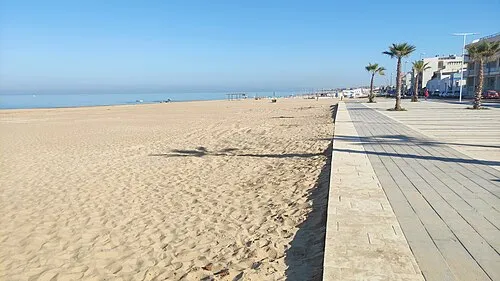
Spiaggia La Lanterna MdeVicente · CC0

Climate of Passo Marinaro
Best months for sightseeingBest months for sightseeing: May–June, October.
This month · November
Outside the best season
Day 20° · Night 13° · Rain 62 mm
- Hottest month
- August (day 30°)
- Coldest month
- February (night 8°)
- Wettest month
- December (73 mm)
- Driest month
- July (1 mm)
Bars: average monthly low and high temperature. Below: precipitation. Monthly averages for 1970–2000 at about 18 km resolution, adjusted for elevation. Highlighted months are mild and relatively dry. Source: WorldClim 2.1 (CC BY 4.0).
Show values as a table
| Month | Jan | Feb | Mar | Apr | May | Jun | Jul | Aug | Sep | Oct | Nov | Dec |
|---|---|---|---|---|---|---|---|---|---|---|---|---|
| Average high (°C) | 15° | 16° | 17° | 19° | 23° | 27° | 29° | 30° | 28° | 24° | 20° | 17° |
| Average low (°C) | 8° | 8° | 9° | 10° | 14° | 18° | 20° | 21° | 19° | 16° | 13° | 10° |
| Precipitation (mm) | 58 | 40 | 32 | 24 | 12 | 4 | 1 | 8 | 29 | 66 | 62 | 73 |
How to get to Passo Marinaro
The nearest airport is Comiso Airport (CIY), 21 km to the northeast as the crow flies. For international flights: Catania-Fontanarossa Airport (CTA) (87 km).
Airports
- Comiso Airport (CIY) Comiso 21 kmnortheast
- Catania-Fontanarossa Airport (CTA) Catania 87 kmnortheast
- Malta International Airport (MLA) Valletta 112 kmsouth
Straight-line distances; road distances are longer. Airport data: OurAirports.
Day trips from Passo Marinaro
Within 100 km: 25 historic and cultural sites, 13 natural sites, 56 lakes, rivers and coasts.
0–25 km6 places
- Spiaggia Donnalucata Beach 19 kmSE
- Capo Scaramia Natural site 9 kmSE
- Spiaggia di Torre di Mezzo Beach 6 kmS
- Spiaggia di Kamarina Beach 3 kmNW
25–60 km30 places
- Monte Scannalupi Mountain 25 kmNE
- Spiaggia Marina di Modica Beach 33 kmSE
- Spiaggia Pozzallo Beach 38 kmE
- Spiaggia Tegolaio Beach 41 kmE
60–100 km58 places
- Gozo Island 92 kmS
- Comino Island Island 94 kmS
- Spiaggia della Plaia Beach 89 kmNE
- Playa di Catania Beach 89 kmNE
Straight-line distances.
Nearby attractions & nature
Everything nearby-
Spiaggia di Kamarina Beach, Vittoria2.9 km NW
-
Spiaggia di Punta Braccetto Beach, Italy4.8 km S
-
Spiaggia La Lanterna Beach, Vittoria4.8 km NW
-
Spiaggia di Torre di Mezzo Beach, Santa Croce Camerina6.4 km S
-
Capo Scaramia Natural site, Santa Croce Camerina8.7 km SE
-
Spiaggia Donnalucata Beach, Italy19 km SE
Sources & licences
Data last updated: · 2 independent sources