Punta Secca
Located in Santa Croce Camerina, Province of Ragusa Coordinates: 36°47′23″ N 14°29′36″ E

- Population
- 226
- 226
- Elevation
- 3 m
- above sea level
- Local time
- UTC+01:00
- Europe/Rome · UTC+01:00
- Airports
- CIY Comiso Airport25 km
- CTA Catania-Fontanarossa Airport91 km
About Punta Secca
Punta Secca is a village. Location: Santa Croce Camerina, Province of Ragusa. Population: 226. Elevation: 3 m.
Punta Secca (Sicilian: Punta Sicca), locally nicknamed ’A Sicca, is a small southern Italian fishing village and hamlet (frazione) of Santa Croce Camerina, a municipality in the Province of Ragusa, Sicily. In 2011 it had a population of 226.
Source: Wikipedia · CC BY-SA 4.0
At a glance
- Built
- 1859
Source: Wikidata
Photos of Punta Secca
-

Rémih · CC BY-SA 4.0 -

Marco M · CC BY-SA 2.0 -

giomodica · CC BY 3.0 -

Mariu223 · CC BY 4.0


Climate of Punta Secca
Best months for sightseeingBest months for sightseeing: May–June, October.
This month · November
Outside the best season
Day 20° · Night 13° · Rain 63 mm
- Hottest month
- August (day 29°)
- Coldest month
- February (night 8°)
- Wettest month
- December (76 mm)
- Driest month
- July (1 mm)
Bars: average monthly low and high temperature. Below: precipitation. Monthly averages for 1970–2000 at about 18 km resolution, adjusted for elevation. Highlighted months are mild and relatively dry. Source: WorldClim 2.1 (CC BY 4.0).
Show values as a table
| Month | Jan | Feb | Mar | Apr | May | Jun | Jul | Aug | Sep | Oct | Nov | Dec |
|---|---|---|---|---|---|---|---|---|---|---|---|---|
| Average high (°C) | 15° | 16° | 17° | 19° | 22° | 26° | 28° | 29° | 27° | 24° | 20° | 17° |
| Average low (°C) | 9° | 8° | 9° | 11° | 14° | 18° | 20° | 21° | 20° | 17° | 13° | 10° |
| Precipitation (mm) | 60 | 41 | 31 | 23 | 11 | 3 | 1 | 7 | 29 | 68 | 63 | 76 |
How to get to Punta Secca
The nearest airport is Comiso Airport (CIY), 25 km to the northeast as the crow flies. For international flights: Catania-Fontanarossa Airport (CTA) (91 km).
Airports
- Comiso Airport (CIY) Comiso 25 kmnortheast
- Catania-Fontanarossa Airport (CTA) Catania 91 kmnortheast
- Malta International Airport (MLA) Valletta 105 kmsouth
Straight-line distances; road distances are longer. Airport data: OurAirports.
Day trips from Punta Secca
Within 100 km: 46 historic and cultural sites, 16 natural sites, 56 lakes, rivers and coasts.
0–25 km8 places
- Spiaggia Sampieri Beach 24 kmE
- Spiaggia di Torre di Mezzo Beach 2 kmNW
- Spiaggia Cava d'Aliga Beach 18 kmE
- Spiaggia di Punta Braccetto Beach 4 kmNW
25–60 km29 places
- Playa Serenusa Beach 55 kmNW
- Lido Panama Beach Beach 48 kmNW
- Manfria Beach 40 kmNW
- Plaja Ulisse Beach 45 kmE
60–100 km81 places
- Maltese Islands Island 97 kmS
- Gozo Island 85 kmS
- Comino Island Island 87 kmS
- Lido Del Carabiniere Beach 90 kmNE
Straight-line distances.
Nearby attractions & nature
Everything nearby-
Capo Scaramia Natural site, Santa Croce Camerina0.3 km S
-
Spiaggia di Torre di Mezzo Beach, Santa Croce Camerina2 km NW
-
Spiaggia di Punta Braccetto Beach, Italy3.9 km NW
-
Spiaggia di Kamarina Beach, Vittoria11 km NW
-
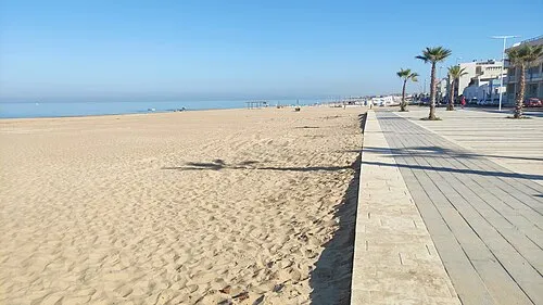 Spiaggia La Lanterna Beach, Vittoria13 km NW
-
Spiaggia Cava d'Aliga Beach, Scicli18 km E
Sources & licences
Data last updated: · 2 independent sources